Nice Today; Rain Returns Late Tomorrow
THIS WEEKEND: High pressure over the area today will allow for us to have one beautiful and slightly warmer day. Skies will be clear to start off with, but as time moves on through the day, we’ll start to see an increase in clouds across the area ahead of a frontal system. No rain for today, but it will not be far off into our future. Highs in the upper 40s to the mid 50s.
An approaching cold front will bring unsettled weather to the state on Sunday, especially during the late afternoon through the remainder of the day. Before the rain arrives, skies will be partly to mostly cloudy. The heavier activity will be over the southern and southwestern parts of the state, but thunder looks unlikely for now. Highs in the mid 40s to the lower 60s.
THE WORK WEEK AHEAD: Rain will continue across the state on Monday through a good portion of the day until a northwesterly flow develops and starts to push the moisture out of the area by the afternoon and evening. Behind the showers, skies will remain partly to mostly cloudy. Highs will top out in the upper 40s to the mid 60s.
A westerly flow develops over the area on Tuesday that will bring drier air into Alabama for the short run. However, that drier air will also be much warmer, as highs reach the upper 50s to the upper 60s with a mix of sun and clouds.
Warm air advection continues to bring warmer air into the area on Wednesday, and there will be showers possible mainly over the northern and northwestern parts of the state during the day. Otherwise, skies will be mostly cloudy with highs in the upper 50s to the lower 70s from north to south.
A developing trough off to the west will usher in a south to southwest flow across the state on Thursday. That will introduce some moisture into our air and may allow for a few scattered showers to develop over the extreme west and southwestern parts of the state. However, most will stay dry and highs will be in the lower 50s to the mid 60s.
Friday will see an increase to those shower chances across the state, as a surface boundary approaches and begins to work its way in and through the area. Those better rain chances will come during the late afternoon through the remainder of the day and into the start of the weekend. However, almost everyone looks to stay dry during the daylight hours except for the southwestern portions of the area. Highs in the lower 50s to the mid 60s.
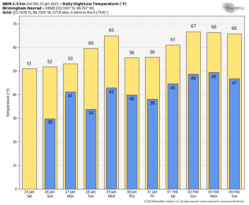
A GLANCE INTO THE FUTURE: Looking at the National Blend of Models for our temperature outlook, we see that sub-freezing temperatures will be saying goodbye for the short future on Tuesday morning, as daytime highs at the NWS Birmingham office at the Shelby County Airport will be in the 50s and 60s and lows in the mid 30s to the upper 40s. Give or take 2–4 degrees considering where your location is.
Category: Alabama's Weather, ALL POSTS, Social Media, Weather Xtreme Videos
About the Author (Author Profile)
Scott Martin is an operational meteorologist, professional graphic artist, musician, husband, and father. Not only is Scott a member of the National Weather Association, but he is also the Central Alabama Chapter of the NWA president. Scott is also the co-founder of Racecast Weather, which provides forecasts for many racing series across the USA. He also supplies forecasts for the BassMaster Elite Series events including the BassMaster Classic.Subscribe
If you enjoyed this article, subscribe to receive more just like it.


