Midday Nowcast: Sunny and Cold with a Snow Pack Along the Gulf Coast
Greetings from a snow covered Macon, Georgia today, as much of Middle Georgia is covered in 2-4 inches of snow. Some locations in my viewing area, received isolated amounts over 6 inches. It is the first measurable snow since 2018 for many locations in Middle Georgia. This is all part of the same winter storm that brought record breaking snows to South Alabama yesterday. Yesterday’s event is the set-up that was needed for a Deep South significant snow storm; cold air in place and a low pressure in the Gulf. Certainly an amazing and historic storm for locations from Texas all along the Gulf Coast and into the Carolinas.
The forecast today, features sunshine in full supply, but it remains very cold with afternoon highs barely above freezing, only in the mid-30s. Tonight will be frigid again with lows likely in the teens for much of North and Central Alabama.
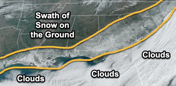
In the image above, with a clear sky across the Deep South, we can see the swatch of snow from Texas to Carolinas from yesterday’s winter storm. The white of the snow has a high albedo and reflects the sunlight, allowing it to be seen from space.
BIRMINGHAM ALMANAC: For January 22nd, the average high for Birmingham is 55° and the average low is 35°. The record high is 78° set in 1937, while the record low is 10° set in 1985. We average 0.15” of precipitation on this date and the record value is 2.70” set in 1980.
WARMING TREND BEGINS: Tomorrow, we finally begin to dig out of the deep freeze across the Deep South. Highs will climb into the 40s tomorrow through Saturday with more sun than clouds these three days. Some spots will see low 50s by Saturday over the southern half of the state.
On Sunday, clouds begin to increase as a weak disturbance will bring rain back to the northern half of the state Sunday afternoon. The rain should become widespread Sunday night into Monday. Rain amounts should be generally under 1/2 inch.
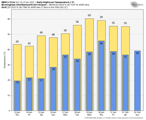
REST OF NEXT WEEK: The weather looks dry Tuesday and Wednesday with highs in the mid to upper 50. On Thursday, we will have another chance of rain. Good news, no signs of any snow or ice issues next week and no signs of severe weather either.
WORLD TEMPERATURE EXTREMES: Over the last 24 hours, the highest observation outside the U.S. was 115.7F at Birdsville Airport, Australia. The lowest observation was -70.2F at Volochanka, Russia.
CONTIGUOUS TEMPERATURE EXTREMES: Over the last 24 hours, the highest observation was 83F at Hollywood, FL. The lowest observation was -27F at Davis, WV.
Category: Alabama's Weather, ALL POSTS, Social Media, Winter Weather
About the Author (Author Profile)
Macon, Georgia Television Chief Meteorologist, Birmingham native, and long time Contributor on AlabamaWX. Stormchaser. I did not choose Weather, it chose Me. College Football Fanatic. @Ryan_StinnetSubscribe
If you enjoyed this article, subscribe to receive more just like it.


