Mid-Morning Update: Snow Moving Into Alabama As A Winter Storm Is Now Underway
VERY COLD: Today is dangerously cold across Alabama as afternoon highs are not going to make it above freezing for much of North and Central Alabama. Tonight single digit lows will be common across North Alabama, while the Interstate 20 corridor will be closer to 10°. Tomorrow the cold air will remain in place with highs in the 30s. These temperatures are around 20-25 degrees below average for this time of year. On Thursday, highs should finally climb into the 40s and again on Friday as a gradual warming trend begins.
BIRMINGHAM ALMANAC: For January 21st, the average high for Birmingham is 55° and the average low is 35°. The record high is 77° set in 1937, while the record low is -6° set in 1985. We average 0.16” of precipitation on this date and the record value is 1.68” set in 1973.
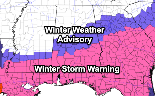
WINTER STORM FOR CENTRAL AND SOUTH ALABAMA: A winter storm warning is in effect today and tonight. Areas along and south of a line from Demopolis to Selma to Montgomery to Phenix City, while a Winter Weather Advisory is in effect as far north as Moundville to Alabaster to Helfin. This event is going to be mainly for areas south of Interstate 20.
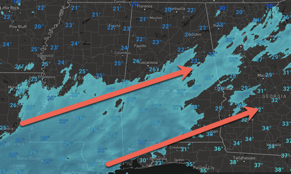
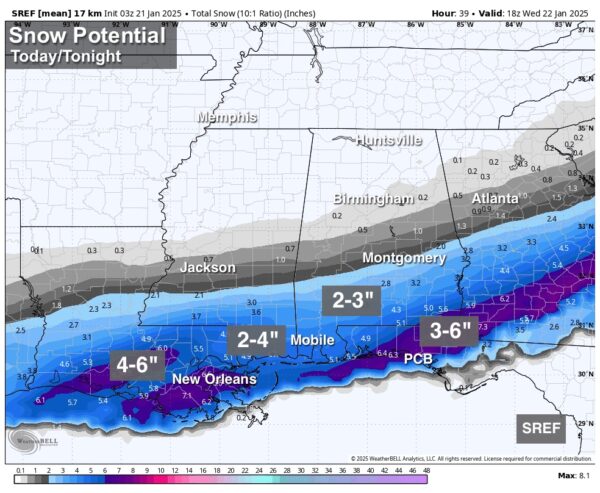
TIMING: The event is now underway as snow is moving into Alabama, and will become widespread during the afternoon and evening hours, mainly south of U.S. 80 corridor in the winter storm warning areas. Many communities in the winter warning over South Alabama will see 2-3 inches of snow, including Mobile which may pick up 4 inches. There could even be a few areas that could see totals up to 4-6 inches down that way as well.
This is one of those rare snow events for Alabama where the farther south you are in the state, the higher the snow totals will be, and yes snow is expected on the beaches of Alabama and Northwest Florida. The snow should be over by midnight. We do want to mention, though snow is showing up on the radar across North Alabama, it is not reaching the ground in most places as the low levels of the atmosphere are very dry and it is evaporating.
IMPACTS: With the very cold air in place and the cold infrastructure, roads will become hazardous quickly where snow falls. Icy travel will continue into Wednesday morning. Temperatures will rise well above freezing South Alabama tomorrow afternoon with some improvement possible, but another freeze is likely Thursday morning with ice still very possible on some roads.
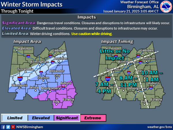
For Central Alabama, light snow is possible in the Winter Weather Advisory places (places like Greensboro, Alabaster, Calera, Clanton, Alexander City, Anniston, Helfin, and Roanoke).But keep in mind any unexpected northward shift in the Gulf low could bring some light snow into Tuscaloosa and Birmingham Metros, and in this very cold airmass even amounts of 1/4 to 1/2 inch can make roads pretty icy.
As the event is now underway, continue to watch for updates today and tonight. As the late, great J.B Elliott always said, with a Deep South snow event, expect a surprise or two along the way.
WARMER WEEKEND: While most places will be in the 20s early Saturday morning, highs over the weekend will be in the 50s, very close to seasonal averages for late January. Saturday will be sunny and dry, but Sunday looks to feature increasing clouds with the chance of some scattered rain showers late in the day and into Monday. Good new, next week looks to feature seasonal temperatures; highs in the 50s, lows in the 30s.
WORLD TEMPERATURE EXTREMES: Over the last 24 hours, the highest observation outside the U.S. was 113.2F at Cunderdin Airfield, Australia. The lowest observation was -69.2F at Volochanika, Russia.
CONTIGUOUS TEMPERATURE EXTREMES: Over the last 24 hours, the highest observation was 76F at Camp Pendleton, CA. The lowest observation was -39F at Grand Lake, CO.
Category: Alabama's Weather, ALL POSTS, Social Media, Winter Weather
About the Author (Author Profile)
Macon, Georgia Television Chief Meteorologist, Birmingham native, and long time Contributor on AlabamaWX. Stormchaser. I did not choose Weather, it chose Me. College Football Fanatic. @Ryan_StinnetSubscribe
If you enjoyed this article, subscribe to receive more just like it.


