Winter Storm Warning For South Alabama Today; Very Cold Air Stays In Place
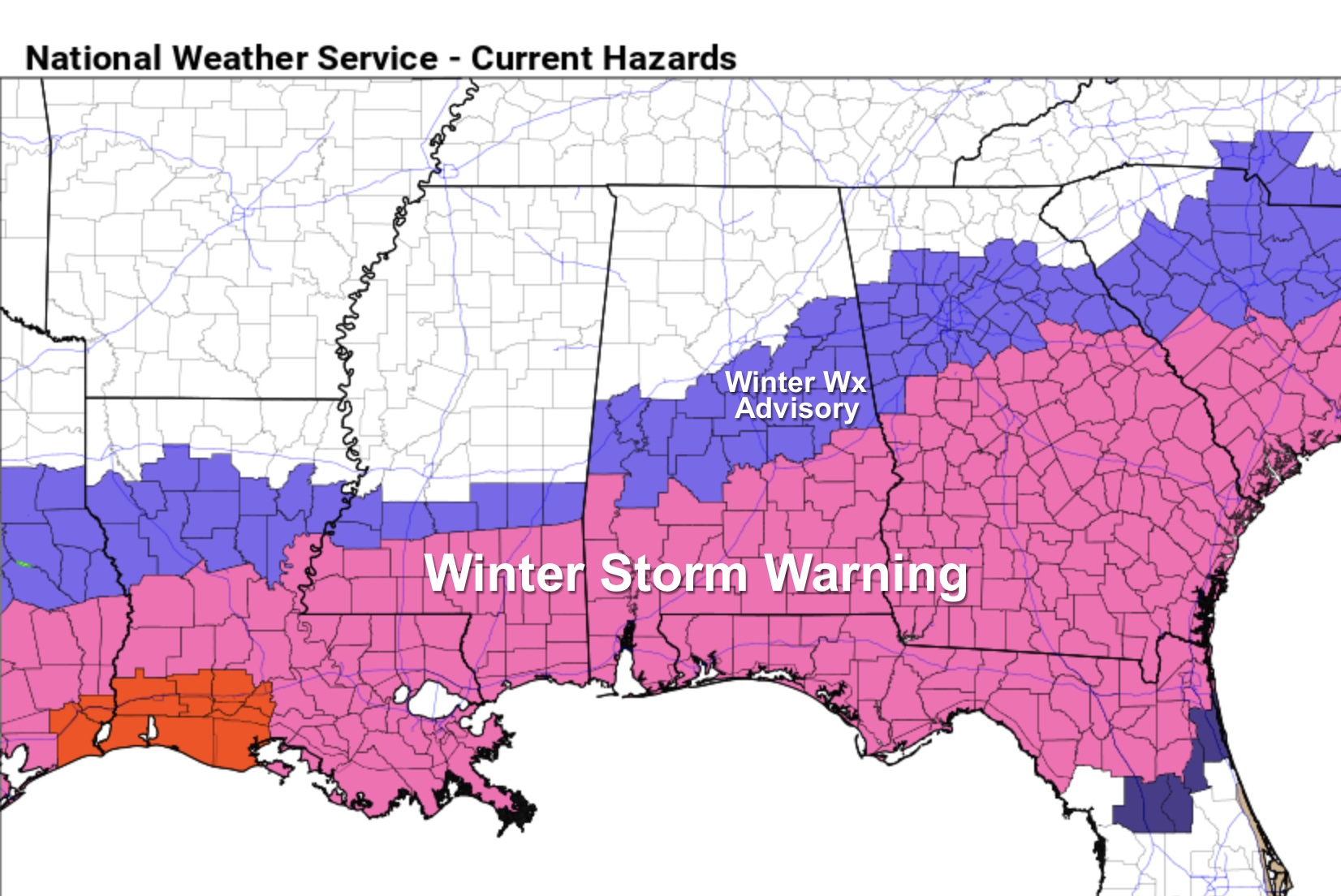
WINTER STORM WARNING: A winter storm warning is in effect today for areas along and south of a line from Thomasville to Montgomery to Opelika. North of the warning, there is a “winter weather advisory” as far north as Eutaw, Centreville, Pelham, Talladega, and Anniston. NWS Birmingham added a few counties to the advisory early this morning… Shelby, Talladega, Calhoun, and Cleburne.
Temperatures will stay below freezing across most of the state today as Arctic remains in place, and a surface low continues to form in the northwest Gulf of Mexico. Here are the key messages on what to expect today…
*There are echoes on radar early this morning (before sunrise), but that precipitation is not reaching the ground due to very dry air in the lower levels.
*Snow will begin to reach the ground later this morning over Southwest Alabama as the column becomes saturated… then becoming widespread across the southern counties of the state during the afternoon and evening hours. Snow amounts in the winter storm warning area will be generally in the 2-3 inch range, with locally heavier amounts. A good chance this system will bring the most snow Mobile has experienced since February 1973. Where banding occurs a few spots could see over 4 inches somewhere between Dothan and Mobile; accumulating snow is likely for places like Gulf Shores, Pensacola, and Fort Walton Beach. Panama City Beach could see some snow.
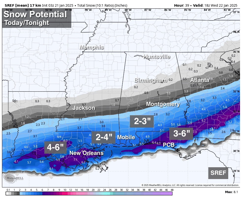
*Driving will become very hazardous across South Alabama and the Florida Panhandle today as snow will accumulate rapidly on road surfaces due to the very cold air in place. The snow will be out of the state by 9:00 p.m., but icy travel will continue into tomorrow morning.
*To the north, in the winter weather advisory area across Central Alabama, amounts will be much lighter (generally under one inch), but in this kind of airmass it doesn’t take much snow for roads to become slick and dangerous.
*For now the winter weather advisory does not include Tuscaloosa, Birmingham, Gadsden, or points north. A few snow flakes are certainly possible, but for now the main travel impact is expected to be to the south. The advisory includes Sumter, Greene, Hale, Bibb, Shelby, Talladega, Calhoun, and Cleburne counties, and areas to the south. But, we all know winter storms can bring surprises, so watch for updates and radar trends this morning.
*Where snow accumulates, icy travel will continue through tomorrow morning. There could be some improvement tomorrow afternoon with strong January sun and temperatures just above freezing, but where moisture lingers icy spots are very possible into Thursday morning.
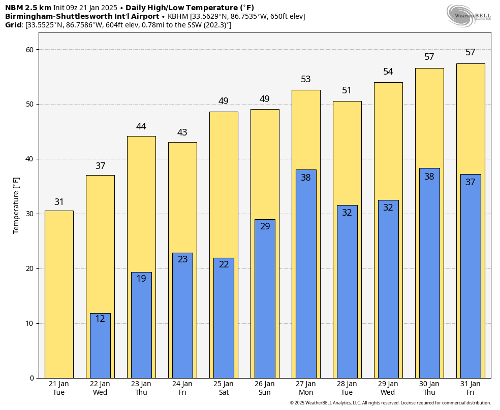
*Tomorrow morning will be the coldest morning of the week with lows in the 6-14 degree range over the northern 2/3 of the state; upper teens are likely down to the Gulf Coast.
A disturbance could bring a few flurries to North Alabama Thursday, otherwise the weather will be dry over the latter half of the week with warmer afternoons; highs will be in the 40s by Thursday and Friday.
THE ALABAMA WEEKEND: Saturday will be dry… after a low in the 18-25 degree range, expect a high close to 50 degrees. Clouds increase Saturday night, and some rain will likely move into the northern half of the state Sunday. The chance of rain will continue into Monday… See the video briefing for maps, graphics, and more details.
ON THIS DATE IN 2010: A tornado touched down in Huntsville over the northern part of Redstone Arsenal. The tornado nearly paralleled I-565 to the south, passing over Memorial Parkway, northern sections of downtown Huntsville, and Five Points before dissipating as it moved up Chapman Mountain. The tornado was down for just over four miles, and three people were injured.
Look for the next video briefing here by 3:00 this afternoon… enjoy the day!
Category: Alabama's Weather, ALL POSTS, Weather Xtreme Videos
About the Author (Author Profile)
James Spann is one of the most recognized and trusted television meteorologists in the industry. He holds the AMS CCM designation and television seals from the AMS and NWA. He is a past winner of the Broadcast Meteorologist of the Year from both professional organizations.Subscribe
If you enjoyed this article, subscribe to receive more just like it.


