Rain Tomorrow Night/Saturday; Arctic Air Arrives Sunday
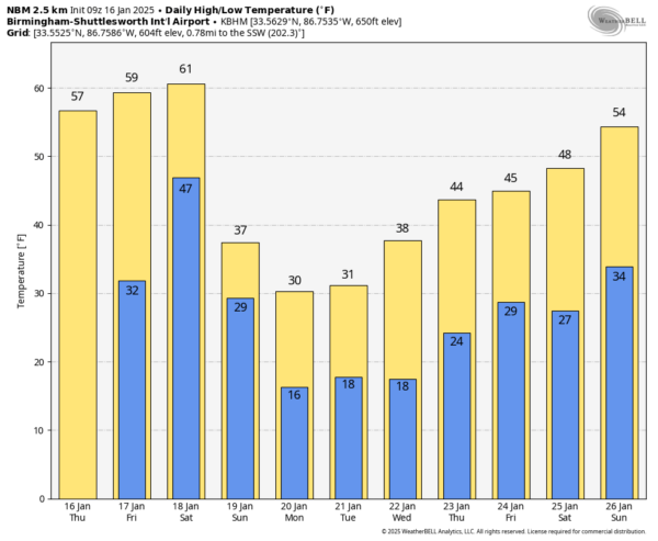
STILL DRY TODAY: Temperatures are generally below freezing over the northern half of the state early this morning, but with a strong January sun we project a high in the 55-65 degree range this afternoon. The day tomorrow will be dry and pleasant, but clouds will gradually increase, and a large mass rain will move into the state tomorrow night.
THE ALABAMA WEEKEND: Rain will diminish by Saturday afternoon… for now it looks like the most widespread rain will come from about midnight tomorrow night through noon Saturday; many places will see over one inch. Temperatures will peak in the low 60s for most places Saturday afternoon. Then, the coldest air so far this season will blow in here Sunday with an icy north wind. We hold in the 30s all day with some slow clearing possible. Wind chill values will be well below freezing over the northern half of the state.
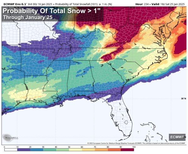
NEXT WEEK: Monday will be dry and very cold. We start the day well down in the teens, North Alabama stays below freezing all day. Beyond that, we continue to see some potential for a winter storm across the southern U.S. during the mid-week period based on consistent signals from global models. But it is still too early to know any details. Snow? Freezing rain/ice? How much? Accumulation potential? Timing? Travel impact? We just can’t answer any of those questions now. Highest probabilities of wintry precipitation are in the Tuesday/Wednesday time frame, but the American GFS model continues to suggest the event will come later in the week Thursday and Thursday night. And, of course, there is always a chance the system is shunted so far south in the Gulf that Alabama gets very little precipitation.
We will begin to have a little clarity tomorrow, and then we have potential to get into specifics over the weekend (especially Sunday). But we can say with confidence the week will be very cold with lows in the teens for the northern half of the state Monday, Tuesday, and Wednesday morning. There is chance some in far North Alabama could go below freezing Sunday, and stay below freezing all the way through Thursday. Now is the time to prepare for 4-5 days of very cold Arctic air.
See the video briefing for maps, graphics, and more details.
ON THIS DATE IN 2008: A winter storm impacted parts of the Deep South from northern Louisiana east through central Mississippi and central Alabama. Heavier snows of 3-4 inches were reported over northeast Wayne County in Mississippi and extended into Choctaw and northern Clarke Counties in southwest Alabama. Lighter snowfall amounts of 1-2 inches were reported over Wilcox and northern Washington Counties.
Look for the next video briefing here by 3:00 this afternoon… enjoy the day!
Category: Alabama's Weather, ALL POSTS, Weather Xtreme Videos


