Midday Nowcast: Gradual Transition From Snow To Wintry Mix To A Cold Rain Across Alabama
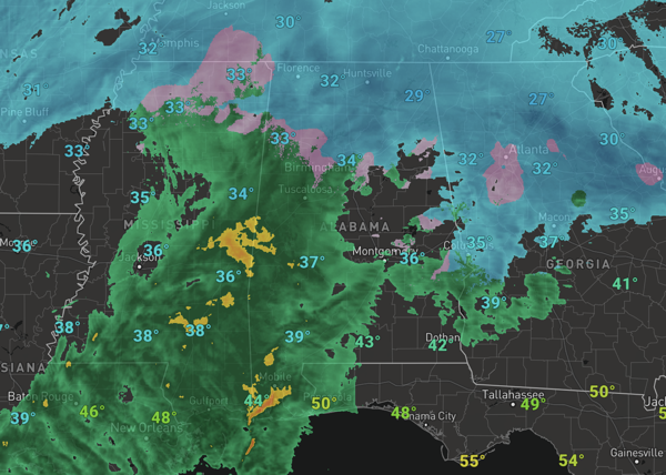
PRECIPITATION TRANSITIONING: After the snowy start to the event, we are seeing the transition to wintry mix and then a cold rain event due to warm air advection from the south. Wintry precipitation accumulations are coming to and end for much of North/Central Alabama as the rain is winning the battle and washing away a lot of what accumulated earlier today. Temperatures will or have climbed above the freezing mark of 32° and many will see mid to upper 30s this afternoon with a very cold rain and some sleet mixed in continuing. We note, the transition could be later this evening across the higher terrain of North and East Alabama.
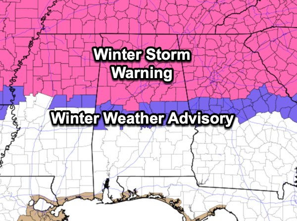
For North/Central Alabama, the Winter Storm Warning remains in effect until 6AM Saturday morning, while the Winter Weather Advisory continues until 3PM Friday afternoon. These times could certainly be adjusted as the event continues.
The precipitation will come to and end tonight, but as temperatures will fall back below freezing, slick spots are likely tonight and into Saturday morning across the northern half of the state. Especially be cautious as there will likely be areas of black ice. Lows tonight will be in the upper 20s and lower 30s.
BIRMINGHAM ALMANAC: For January 10th, the average high for Birmingham is 54° and the average low is 35°. The record high is 81° set in 1949, while the record low is 2° set in 1982. We average 0.16” of precipitation on this date and the record value is 2.74” set in 1972.
WEEKEND WEATHER Tomorrow and Sunday will remain cold with highs in the 40s and lows in the 20s; North Alabama will like hold in the 30s tomorrow. A few lingering snow flurries remain possible tomorrow, but the sky will be clearing and the weekend will be dry. Sunday will feature a sunny sky.
STAYING COLD: Next week, the cold weather will continue with below average temperatures, highs in the 40s and lows in the 20s. Most of the week will be dry, but some rain will return to Alabama by the end of the week. For now, it looks to be an all rain event. Then another surge of cold air will drop into Alabama the following week. With cold air remaining in place, we may have to deal with more winter weather mischief in the coming weeks.
WORLD TEMPERATURE EXTREMES: Over the last 24 hours, the highest observation outside the U.S. was 114.8F at Urandangi Aerodrome, Australia. The lowest observation was -75.5F at Summit, Greenland.
CONTIGUOUS TEMPERATURE EXTREMES: Over the last 24 hours, the highest observation was 80F at several locations in Southern California. The lowest observation was -27F at Stub Creek, CO.
Category: Alabama's Weather, ALL POSTS, Current Warnings, Social Media, Winter Weather


