Midday Nowcast: Winter Storm On The Way Friday for North/Central Alabama
The weather today is sunny and cold with upper 30s to lower 40s, but clouds will begin to increase later today as our winter storm approaches. For much of North/Central Alabama, you need to be taking any final precautions to deal with a winter weather event tomorrow across Alabama. We possess no knowledge of future road conditions, please see the information provided by ALDOT on their ALGO web site/app. Additionally, we have no say in whether or not schools will be opened or closed tomorrow.
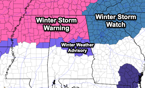
WINTER STORM WARNING: A winter storm warning is in effect for all of North Alabama and extends as far south as Fayette, Birmingham, and Anniston. A winter weather advisory has been issued for places as far south as Tuscaloosa, Clanton, Wetumpka, and Opelika.
The difference between warning and an advisory:
A “Winter Storm Warning” is issued when a combination of hazardous winter weather is occurring, is imminent, or is expected. Winter Storm Warnings are issued when one or more of the following is expected:
-Snowfall of 2″ or greater
-Freezing rain/drizzle (ice) accumulations greater than or equal to 1/4″.
-Sleet (ice pellets) accumulations 1/2″ or greater
A “Winter Weather Advisory” is issued for a winter weather situation that causes significant inconveniences, but does not meet warning (see above) criteria. The winter weather can still be life threatening if caution is not exercised. A Winter Weather Advisory is issued if more than one type of hazardous winter weather is expected, is occurring, or is imminent:
-Sleet (ice pellets) accumulations of less than 1/2″
-Freezing rain/drizzle (ice) accumulations less than 1/4″
-Snowfall accumulations of 1/4″ to 2″ (A dusting of snow does not require an advisory)
In short, both indicate that winter weather hazards are expected or ongoing, but the warning is the more severe of the two. It is important to note, that it doesn’t matter if you are in a warning of advisory, both are issued for hazardous types of winter weather which can cause travel issues. Pay attention to both alerts when they are issued.
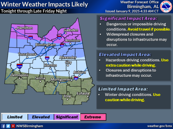
After midnight tonight, a wintry mix of snow, sleet, and freezing rain will move into Alabama and with surface temperatures below freezing, icy/hazardous travel is expected in the warning and advisory areas. Expect bridges and overpass to become slick quickly, while other roads will take a bit more time, but expect travel impacts the first half of Friday.
Through the day, warm air advection will cause the wintry mix to transition into a cold rain as temperatures climb into the mid 30s, which should ease the icy travel to some degree, but many bridges and overpasses could remain icy, especially the farther north you are in the state.
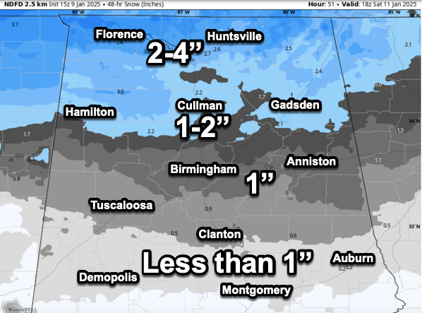
More changes in the potential snowfall totals, and for now, here is a rough idea of what is possible. The heavier totals will be over the Tennessee Valley of the state where 2-4” will be possible; 1-2” will be possible north of Birmingham, around the Birmingham Metro and along Interstate 20, amounts around 1” are possible. For areas between Birmingham and Montgomery, amounts will be generally less than one inch. But again, the totals can still change over the next 24 hours.
It is important to note that many in the winter storm warning area will see more sleet and freezing rain than snow. A few spots could see ice accumulation to 1/10?. This doesn’t sound like much, but it can have a high impact on travel. While we don’t expect any major power outages, ice on large tree limbs could lead to some scattered spots going in the dark.
The precipitation will come to and end tomorrow night, but temperatures will fall back below freezing, and slick spots are likely Friday night and into Saturday morning across the northern half of the state. Especially be cautious as there will likely be areas of black ice.
As with any winter weather event in Alabama and the Deep South, this is very difficult forecast to communicate. Many people will be disappointed or surprised by the totals they see or do not see. As the late, great JB Elliot always said, expect a surprise of two when it comes to winter weather events in Alabama. Understand, this forecast can and will likely change some over the next 24 hours, make sure you are getting the most up-to-date forecasts.
BIRMINGHAM ALMANAC: For January 9th, the average high for Birmingham is 54° and the average low is 35°. The record high is 77° set in 1949, while the record low is 5° set in 1970. We average 0.16” of precipitation on this date and the record value is 1.89” set in 1977. We do note, that on this day in 1962, Birmingham received 3.5 inches of snow.
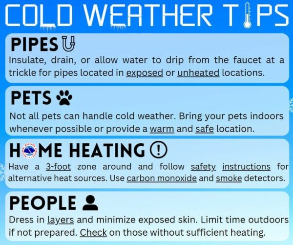
COLD WEATHER SAFETY: Everyone should review their cold weather safety involving pipes, pets, home heating, and people. For pipes, insulate, drain, or allow water to drip from the faucet at a trickle for pipes located in exposed or unheated locations. Not all pets can handle cold weather. Bring your pets indoors whenever possible or provide a warm and safe location. For alternative heating sources like space heaters and wood stoves, have a 3-foot zone around and follow safety instructions. Utilize carbon monoxide and smoke detectors. For people, dress in layers and minimize exposed skin. Limit time outdoors if not prepared. Check on those without sufficient heating.
WEEKEND WEATHER Saturday and Sunday will remain cold with highs in the 40s and lows in the 20s. A few lingering snow flurries remain possible Saturday, but the sky will be clearing and the weekend will be dry. Sunday will feature a sunny sky.
Next week, the cold weather will continue with below average temperatures, highs in the 40s and lows in the 20s. Most of the week will be dry, but some rain will return to Alabama by the end of the week. For now, it looks to be an all rain event. Then another surge of cold air will drop into Alabama the following week. With cold air remaining in place, we may have to deal with more winter weather mischief in the coming weeks.
WORLD TEMPERATURE EXTREMES: Over the last 24 hours, the highest observation outside the U.S. was 113.0F at Cloncurry Airport, Australia. The lowest observation was -50.3F at Delyankir, Russia.
CONTIGUOUS TEMPERATURE EXTREMES: Over the last 24 hours, the highest observation was 76F at Oceanside, CA. The lowest observation was -20F at McMillian, MI.
Category: Alabama's Weather, ALL POSTS, Current Warnings, Current Watches, Severe Weather, Winter Weather


