Midday Nowcast: Winter Storm Watch Issued Ahead of Winter Storm
Today and tomorrow we continue to deal with cold weather with highs in the upper 30s to lower 40s, with a mix of sun and clouds. These temperatures are 10-15 degrees below average for this time of year. Nights are bone chilling with upper teens and lower 20s.
BIRMINGHAM ALMANAC: For January 8th, the average high for Birmingham is 54° and the average low is 35°. The record high is 74° set in 2008, while the record low is 7° set in 1942. We average 0.16” of precipitation on this date and the record value is 4.11” set in 1953.
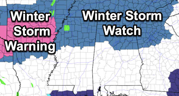
USA BRIEF: High winds and low relative humidity will produce critical to extremely critical fire weather in southern California through Thursday. Impactful wintry weather is becoming more likely Thursday morning through Friday evening for portions of Texas into the Lower Mississippi Valley and Mid-South before possibly moving through the Mid-Atlantic on Saturday. Winter Storm Watches are being raised.
WINTER STORM WATCH: Is in effect for much of North/Central Alabama including for places as far south as Millport, Birmingham, Sylacauga, and Roanoke. This will become a Winter Storm Warning, so now is the time to prepared for a high impact winter weather event in these areas.
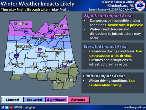
For now, this is the current forecast, but understand this will change some in the coming days. A wintry mix of snow, freezing rain, and sleet will move into Alabama during the pre-dawn hours Friday, while a cold rain is expected across South Alabama.
As the precipitation begins, evaporative cooling will likely bring temperatures down into the 25-30 degree range over the northern half of the state, where icy/hazardous road problems will likely begin. Wintry precipitation is possible down into Central Alabama, potentially as far south as Demopolis, Montgomery, and Phenix City and these places could see a brief period of freezing rain. We are likely to see a Winter Weather Advisory issued in these areas.
Temperatures should slowly warm into the mid 30s during the day Friday as slightly warmer air surges north from the south, and the wintry mix should transition to a rain and sleet event by the midday and afternoon hours, making for a very cold rain for areas along the Interstate 20 corridor. However, for areas along and north of U.S. 278 (Hamilton to Cullman to Gadsden), precipitation will likely remain all snow through the event.
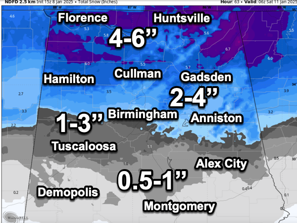
As expected, snowfall totals are increasing for this event, and snow amounts of 4-6 inches are now forecast for the Tennessee Valley of North Alabama. Totals of 2-4 inches are forecast for places like Anniston and Gadsden in Northeast Alabama. Around 1-3 inches for Birmingham… Tuscaloosa could see one inch or so. Some freezing rain could create icy bridges down to the U.S. 80 and I-85 corridor for a brief time Friday morning.
Roads conditions will remain icy across the Tennessee Valley through Saturday, but areas to the south should see improvement by Saturday afternoon.
As with any winter weather precipitation event in Alabama and the Deep South, winter weather forecasts are very difficult. Understand, this forecast can and will likely change some in the coming days, so make sure you are getting the most up-to-date forecasts. Every hour we get closer to the event, we will have a better understanding of how the event should play out. But my advice, make all preparations today and tomorrow, and once you get in Thursday evening/night, plan to stay hunkered down through Friday, Friday night, and into Saturday as road and travel conditions will not be ideal. Better safe than sorry, as we do not know how road conditions will be or could change through the event.
Saturday and Sunday will remain cold with highs in the 40s and lows in the 20s. A few lingering snow flurries/showers remain possible Saturday, but the weekend will be dry. Where snow cover lingers in the Tennessee Valley, temperatures could drop into the 10-15 degree range early Sunday morning with a clear sky and light wind. The cold weather will continue into next week as the pattern will continue allow for below-average temperatures. And again with cold air remaining in place, we may have to deal with more winter weather mischief in the coming weeks.
COLD WEATHER SAFETY: Everyone should review their cold weather safety involving pipes, pets, home heating, and people. For pipes, insulate, drain, or allow water to drip from the faucet at a trickle for pipes located in exposed or unheated locations. Not all pets can handle cold weather. Bring your pets indoors whenever possible or provide a warm and safe location. For alternative heating sources like space heaters and wood stoves, have a 3-foot zone around and follow safety instructions. Utilize carbon monoxide and smoke detectors. For people, dress in layers and minimize exposed skin. Limit time outdoors if not prepared. Check on those without sufficient heating.
WORLD TEMPERATURE EXTREMES: Over the last 24 hours, the highest observation outside the U.S. was 111.7F at Urandangi Aerodrome, Australia. The lowest observation was -49.7F at Delyankir, Russia.
CONTIGUOUS TEMPERATURE EXTREMES: Over the last 24 hours, the highest observation was 78F at Camp Pendleton, CA. The lowest observation was -31F at Peter Sinks, UT and Stub Creek, CO.
Category: Alabama's Weather, ALL POSTS, Current Watches, Social Media, Winter Weather


