Winter Storm Watch Issued For Friday; Cold/Dry Today
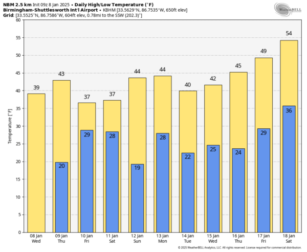
COLD, DRY THROUGH TOMORROW: Cold air stays locked in place across the Deep South through the weekend; we will be dry today and tomorrow with highs in the 37-43 degree range for most places.
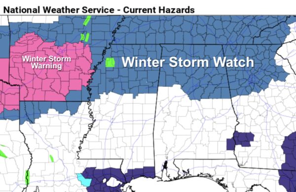
WINTER STORM WATCH: A winter storm watch has been issued for Friday for about the northern third of Alabama… for places as far south as Millport, Birmingham, Sylacauga, and Roanoke.
Here are the key messages for Friday’s winter storm….
*A mix of snow, sleet, and some freezing rain will move into West and North Alabama very early Friday morning; for most places it begins in the 3:00 to 6:00 a.m. time frame. A cold rain will begin over South Alabama.
*As the precipitation begins, evaporative cooling will likely bring temperatures down into the 25-30 degree range over the northern half of the state, where icy/hazardous road problems will likely begin. Wintry precipitation is possible down into Central Alabama, potentially as far south as Greensboro, Montgomery, and Phenix City (these places could see a brief period of freezing rain).
*During the day, the warm air advection process should be responsible for snow and freezing rain changing to a cold rain across Central Alabama. For example, in the Birmingham metro morning snow/freezing rain should be just a cold rain by Friday afternoon with temperatures creeping up into the mid 30s. However, for areas along and north of U.S. 278 (Hamilton to Cullman to Gadsden), precipitation will likely remain all snow through the event.
*Snow amounts of 4-6 inches are now forecast for the Tennessee Valley of North Alabama. Totals of 2-3 inches are forecast for places like Anniston and Gadsden in Northeast Alabama. Around 1-2 inches for Birmingham… Tuscaloosa could see one inch or so. Some freezing rain could create icy bridges down to the I-85 corridor for a brief time Friday morning.
*Roads conditions could very remain icy across the Tennessee Valley through Saturday, but areas to the south should see improvement by Saturday afternoon.
*Please understand I possess no knowledge of future road conditions in any specific location at any given time. Please see the ALGO traffic sites for information on road conditions as the event unfolds.
*A few lingering flurries are possible Saturday, but the weekend will be dry. Where snow cover lingers (mainly the Tennessee Valley), temperatures could drop into the 10-15 degree range early Sunday morning with a clear sky and light wind.
*Please understand forecasting the future, especially when it comes to winter storms in Alabama, isn’t easy. Know this forecast could change between now and Friday.
Next week looks mostly dry with highs in the 40s and lows in the 20s; the next storm system will likely bring rain (no snow) toward the end of the week. See the video briefing for maps, graphics, and more details.
ON THIS DATE IN 1973: Georgia’s worst ice storm since 1935 occurred from the 7th through the 8th. Freezing rain and sleet began during the early morning hours on Sunday the 7th and ended in most areas on Monday. Total damage was estimated at well over $25 million. The electric power companies suffered losses estimated at $5 million, and telephone companies had another $2 million in damages. Some schools were closed for more than a week.
Look for the next video briefing here by 3:00 this afternoon… enjoy the day!
Category: Alabama's Weather, ALL POSTS, Weather Xtreme Videos


