Sunday, January 5th Weather Briefing Video: Severe Threat Late Today; Wintry Chances Late in the Week
Please excuse the wrong date on today’s video. This is the Sunday, January 5th Weather Briefing Video, contrary to what my billboard says…
A COOL AND CLEAR START BEFORE RAIN RETURNS
Saturday brought plenty of sunshine across Central Alabama, but temperatures remained below normal. Highs peaked at 52°F in Tuscaloosa, 51°F in Birmingham, and 50°F in Anniston, all coming in several degrees cooler than average for early January. Overnight lows dipped into the mid to upper 20s, with clear skies and light winds contributing to efficient radiational cooling. By late afternoon, high clouds began streaming in from the west, signaling the approach of a developing storm system set to bring widespread rain and cooler conditions on Sunday.
CLOUDY WITH INCREASING SHOWERS ON SUNDAY
Clouds will thicken overnight, and scattered showers will develop early Sunday morning, first affecting western Alabama and spreading eastward through the day. With increasing southeast winds and warmer air advecting into the region, morning temperatures will rise steadily into the mid-30s to low 40s. By afternoon, most areas will be experiencing light to moderate rain, with temperatures reaching the upper 50s to low 60s. Winds will increase to 10-20 mph, with gusts up to 30 mph, especially west of I-65. Rainfall totals through Sunday afternoon should remain light, generally less than half an inch.
STRONG STORMS POSSIBLE SUNDAY NIGHT
Sunday night will bring a more organized line of storms as a powerful cold front approaches from the west. A marginal risk (level 1 of 5) for severe weather is in place for western Alabama, where the main threats will be damaging winds and an isolated tornado or two. Rainfall totals of 1 to 1.5 inches are expected by Monday morning, with locally higher amounts possible west of I-65. As the line progresses eastward, it will weaken, and severe weather is unlikely east of I-65.
TURNING COLDER ON MONDAY WITH A CHANCE OF FLURRIES
By early Monday morning, the front will have moved through, ushering in much colder air. Temperatures will fall into the mid-30s by sunrise, and strong northwest winds will make it feel even colder, with wind chills in the 20s. Some wrap-around moisture could result in light snow or flurries across northwestern Alabama, but accumulations are not expected. Monday will remain cold and breezy, with highs struggling to reach the upper 30s to low 40s.
BITTER COLD MIDWEEK WITH A WATCH ON FRIDAY
Tuesday through Thursday will feature dry but bitterly cold conditions as an Arctic air mass settles over the region. Morning lows will plunge into the upper teens to low 20s, with wind chills in the low teens. Highs during the day will struggle to climb out of the 30s, despite ample sunshine. Attention then shifts to Friday, as a developing Gulf low may bring the potential for wintry weather to parts of Alabama. Current guidance hints at a wintry mix early Friday before transitioning to rain by midday, but uncertainty remains high, and details will continue to evolve throughout the week.
WINTER STORM BLAIR TO SLAM THE CENTRAL PLAINS AND MIDWEST
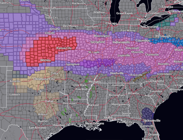
While Alabama braces for rain and storms, a significant winter storm named Blair is taking aim at the Central Plains, Midwest, and Mid-Atlantic this weekend into early next week. Blizzard warnings are in effect from Kansas into northwest Missouri, where 12-18 inches of snow are expected, potentially making it a top-five event for Kansas City, where 13.8 inches would be enough to crack the record books. Further east, 8-12 inches of snow are forecast for Indianapolis, while Cincinnati could see 5-8 inches. In the Mid-Atlantic, Washington, D.C. is bracing for its first significant snow event since early 2022, with 6 inches of snow expected by Monday. In addition to snow, significant ice accumulations are likely across parts of Kentucky, southern Indiana, and southern Ohio, with over a quarter of an inch of ice possible, leading to dangerous travel conditions, downed trees, and power outages.
FOCUS ON HURRICANE HELENE’S IMPACTS IN THE CAROLINAS
Monday night’s WeatherBrains episode will take a deep dive into the lingering impacts of Hurricane Helene, focusing on the extreme rainfall and flooding that affected Upstate South Carolina and western North Carolina. Joining the panel will be Trisha Palmer, Warning Coordination Meteorologist at the NWS Greenville-Spartanburg, SC, whose office was on the front lines of forecasting and providing decision support during the event. Adding a unique angle, listener Joel Genung suggested geologist Philip Prince, who has been studying the long-term surface impacts from Helene’s rainfall. Together, they will explore how the storm’s record-setting deluge transformed communities and landscapes, offering valuable insights into both the meteorological and geological perspectives of high-impact tropical systems.
BEACH FORECAST: HIGH RIP CURRENT RISK THROUGH MONDAY
If you’re headed to the coast, be prepared for rough surf and hazardous conditions. A high rip current risk will be in effect from Sunday morning through late Monday night as strong southerly winds increase surf heights to 4 to 6 feet. Water temperatures remain near 60°F, and beachgoers should exercise caution due to the elevated rip current threat. Conditions will improve midweek as winds shift offshore and seas subside behind the departing cold front.
ON THIS DATE IN 2010
Warming centers were opened in Birmingham as cold weather had Alabama and much of the Central and Eastern United States in its grip. Birmingham was recording its third of 13 consecutive days with lows of 24F or lower, an all time record. It would also be the coldest first 15 days of January in Magic city history. Interestingly enough, no record lows were set at Birmingham. The coldest morning lows during the streak was 14F on the 5th and 11th.
Category: Alabama's Weather, ALL POSTS, Severe Weather, Social Media, Winter Weather


