Windy With Rain Moving In Sunday; Much Colder Next Week
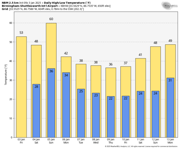
DRY THROUGH TOMORROW: A dry cold front will pass through Alabama today with scattered clouds; expect a high in the 50s this afternoon, which is right at average values for early January. Tomorrow will be a bit colder; temperatures won’t get out of the 40s over the northern half of the state after starting the day in the 20s.
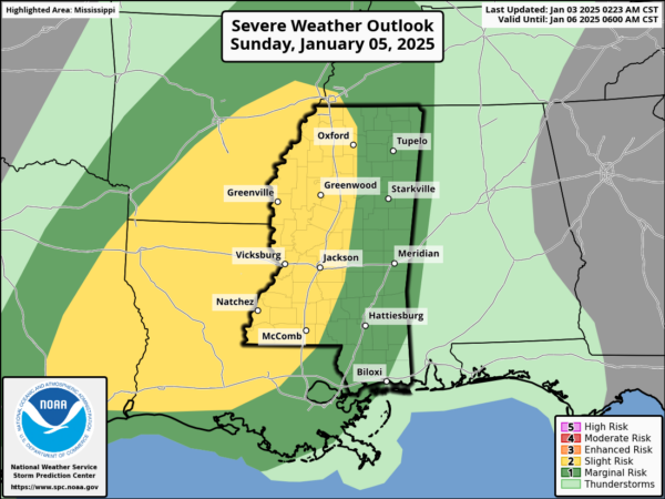
STORM NUMBER ONE: Clouds will increase tomorrow night, and Sunday will be a cloudy, windy day with rain moving in ahead of a storm system. SPC has defined a risk of severe thunderstorms west of Alabama over MS/LA/AR Sunday, but the threat of severe storms in Alabama looks fairly low at this point as the cold front moves through Sunday night due to the lack of surface based instability.
Gradient winds (not related to thunderstorms) could gust to 30/40 mph in spots late Sunday and Sunday night.
NEXT WEEK: Rain ends very early Monday; the day will be windy and much colder with temperatures holding in the 30s over the northern half of the state. The wind chill index will remain below freezing for much of the state, and a few scattered light snow flurries are possible over the northern counties. The weather looks dry but very cold Tuesday through Thursday with highs in the 30s for the northern 2/3 of Alabama… lows will be in the 16-26 degree range for most places. Freezing temperatures are likely down to the Gulf Coast.
STORM NUMBER TWO: Global models continue to show signals of a surface wave/low forming over the northern Gulf of Mexico late in the week on Friday. With cold air in place, this opens the door for some potential for “wintry precipitation” across parts of the Deep South Friday or Friday night (January 10).A number of ensemble members suggest there could be some potential for snow across Alabama, but there is no skill in a specific forecast at this point. We simply don’t know who gets snow, how much will accumulate (if any at all), or if there will be any impact (societal or travel).
We won’t have real clarity until “storm number one” gets out of here Sunday night/Monday. See the video briefing for maps, graphics, and more details.
ON THIS DATE IN 1949: During the late afternoon hours, an estimated F4 tornado destroyed Warren, Arkansas. The tornado killed 55 people and injured more than 250 others. The destruction of the Bradley mill displaced 1,000 employees.
ON THIS DATE IN 2023: A long-duration severe weather event occurred from the late morning hours of Tuesday, January 3rd to the early
morning hours of Wednesday, January 4th. Several rounds of rain and thunderstorms impacted Central Alabama, producing a total of 14 tornadoes, along with damaging straight-line winds, quarter size hail, and flooding. Most of the tornadoes were rated EF-0 or EF-1; there was one rated EF-2 at Lake Jordan just north of Holtville/Slapout.
Look for the next video briefing here by 3:00 this afternoon… enjoy the day!
Category: Alabama's Weather, ALL POSTS, Weather Xtreme Videos


