Dry Through Saturday; Rain Returns Sunday/Sunday Night
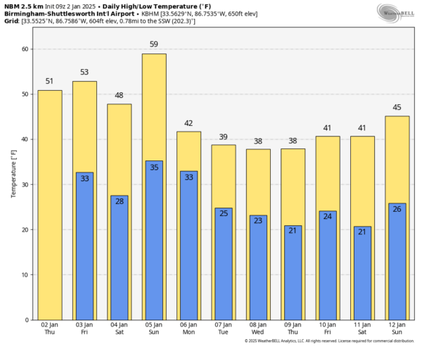
COOL DAYS, COLD NIGHTS: Alabama’s weather won’t change much through Saturday with mostly sunny cool days and clear cold nights. Highs will be in the 50s today tomorrow, then dropping into the 40s Saturday over the northern counties after the passage of a dry “Alberta Clipper” Friday night.
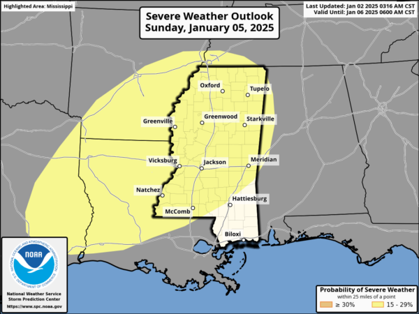
Then a dynamic weather system will bring rain into the state Sunday and Sunday night. We note SPC has defined a risk of severe thunderstorms for the extreme western part of Alabama, and westward across much of Mississippi. Thankfully surface based instability will be low, and the overall threat of severe storms here remains very limited. Rain amounts will be around one inch for the northern half of the state, with amounts closed to 1/2 inch for South Alabama.
Gradient winds (not related to thunderstorms) will ramp up late in the weekend, possibly gusting to 30/40 mph at times.
INTO THE DEEP FREEZE: Rain ends very early in the day Monday, followed by much colder air and an icy north wind. Temperatures will hold in the 30s over North Alabama, and a few snow flurries are possible in the cold air. The weather will be cold and dry Tuesday and Wednesday.
Model madness continues concerning our weather Thursday and Friday (Jan 9-10). The American GFS continues to hint at a surface low in the northern Gulf of Mexico with potential for a winter storm over parts of Alabama, while the European and Canadian global models show basically nothing. Still too early to know if we have any snow or ice, but expect much better clarity by the weekend. See the video briefing for maps, graphics, and more details.
ON THIS DATE IN 2022: Heavy snow occurred in North Alabama the night of January 2, 2022 with 2-4 inches of snow common and pockets of 5-7 inches. Across Central Alabama, totals were much lower, generally a dusting to one-half inch, primarily on elevated surfaces such as decks, roofs, and vehicles. Due to the warm ground, accumulating snow was dependent on sufficient snowfall rates, and this event was another good example of high snow rates being able to overcome a warm surface. The rapid change from record heat and thunderstorms to freezing temperatures and snow made for quite an experience for Southeast U.S. standards. An occurrence of thundersnow was observed in Tuscaloosa County via a cloud-to-ground lightning strike indicated on the lightning sensor network. Gusty winds also accompanied this system with measured gusts between 40 to 50 mph in areas, which took down some trees.
Look for the next video briefing here by 3:00 this afternoon… enjoy the day!
Category: Alabama's Weather, ALL POSTS, Weather Xtreme Videos


