Dry/Seasonal Temps Through Saturday; Rain Returns Sunday
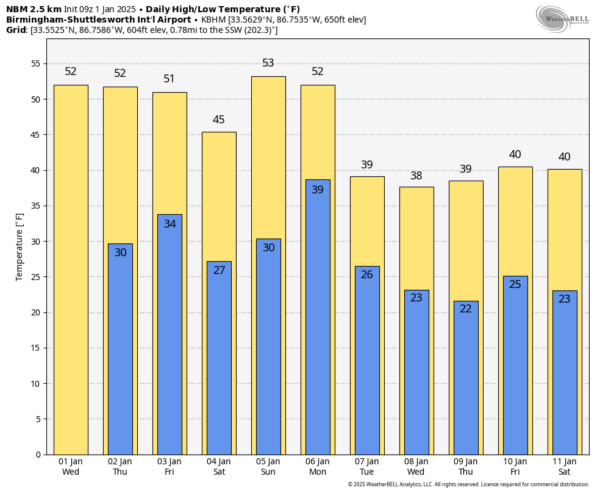
CALM DAYS: Cooler air has dropped into Alabama, and temperatures will be very close to average levels through Friday with mostly sunny days and fair nights. Highs generally in the low to mid 50s, lows in the low to mid 30s.
THE ALABAMA WEEKEND: An “Alberta Clipper” will pass north of Alabama Friday, and will pull down colder air as the weekend begins. Saturday will feature a mostly sunny sky, but highs will be only in the 40s over the northern 2/3 of the state after starting the day with lows in the 20s.
A dynamic weather system will bring rain back into the Deep South beginning Sunday, continuing Sunday night. We note SPC has defined a risk of severe thunderstorms west of Alabama Sunday (over parts of MS/LA/AR/TX), and we could very well have a few strong storms around here Sunday night. But, forecast instability values are very marginal, and the overall risk of severe storms looks low at this point.
NEXT WEEK: Rain ends Monday morning, and it looks like temperatures will fall into the 30s during the day over the northern half of Alabama with a brisk north wind. Then, very cold air settles into the Deep South for the next of the week. Highs will be in the 30s over the northern counties, with 40s for South Alabama. Morning lows will be mostly in the 20s, but teens are likely for some North Alabama communities.
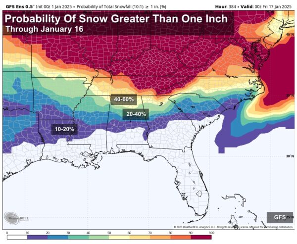
Global models continue to hint at a potential surface low forming in the Gulf of Mexico over the latter half of the week. The American GFS global model shows a big snow event for North Alabama Thursday (with a cold rain for the southern counties), but the reliable European global model shows no precipitation at all. It is simply still too early to know if any “winter mischief” will be involved with the cold air late next week.
A reinforcing shot of cold, Arctic air will likely arrive by the following weekend; temperatures will likely remain well below average across the Deep South into mid-January… See the video briefing for maps, graphics, and more details.
ON THIS DATE IN 1964: Bear Bryant said later that the only thing that could have messed up his eighth ranked Alabama team’s chances in the 1964 Sugar Bowl against 6th ranked Ole Miss in New Orleans would have been if it were to snow.
Well, much to his chagrin, it did snow the night before the January 1st game in the Crescent City. It snowed an amazing 4 ½ inches. Snow was covering the field at Tulane Stadium (site of the game before the Superdome was built) on the morning of January 1, 1964.
The “New Year’s Eve Snow” in the Deep South also dumped an incredible 19.2 inches at Muscle Shoals (still a record for the state of Alabama), 17.1 inches of snow on Huntsville. Much of Northwest Alabama was buried under 15-17 inches of snow. Roofs and awnings collapsed under the weight of the snow. The snow paralyzed much of the area for up to three days, closing schools and businesses.
To the south, 15 inches of snow fell at Meridian, and over 10 inches at Bay. St. Louis MS.
Mobile picked up two inches. Birmingham picked up 8.40 inches of snow, the fifth biggest snowstorm in the city’s history.
Oh, Alabama won the game by a 12-7 margin.
Look for the next video briefing here by 3:00 this afternoon… enjoy the day!
Category: Alabama's Weather, ALL POSTS, Weather Xtreme Videos


