Cooler Days Ahead; Much Colder Next Week
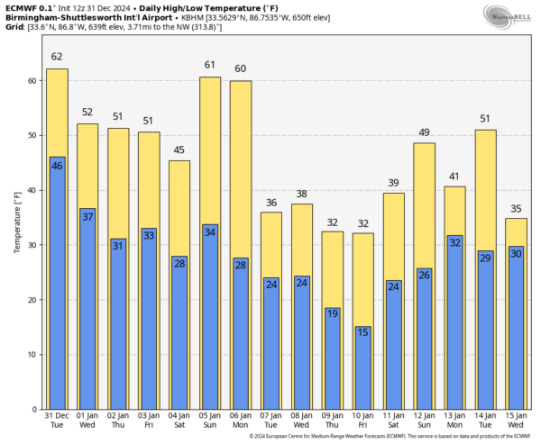
WINDY AFTERNOON: Westerly winds are gusting to 30/35 mph across much of North Alabama this afternoon with mostly sunny sky. Temperatures range from the 50s over the northern counties, to the 70s over South Alabama. Cooler air will continue to drop southward, and most places will see a low tomorrow morning in the 34-40 degree range with a clear sky. Winds will subside after sunset.
Expect a cooling trend over the latter half of the week; highs will be in the 50s tomorrow and Thursday, then falling into the 40s over the northern half of the state Friday. Lows will be mostly in the 30s.
THE ALABAMA WEEKEND: An “Alberta Clipper” will pull in colder air; on Saturday highs will be in the 40s after starting the day in the 20s. The sky will be partly to mostly sunny. Clouds will increase Sunday, and rain is likely statewide late Sunday, Sunday night, and into Monday morning. We note the American global model (GFS) suggests there could be some risk of light freezing rain over North Alabama late Sunday and Sunday night, but the reliable European global model shows only rain, which we believe is the correct solution for now based on the expected thermal fields. Highs Sunday will range from the 40s over North Alabama to the 50s for the southern counties of the state.
COLD WAVE NEXT WEEK: Rain ends Monday morning, and temperatures will likely fall into the 30s as a long duration cold wave begins. A few snow flurries are possible over North Alabama in the colder air Monday, but for now we expect no impact.
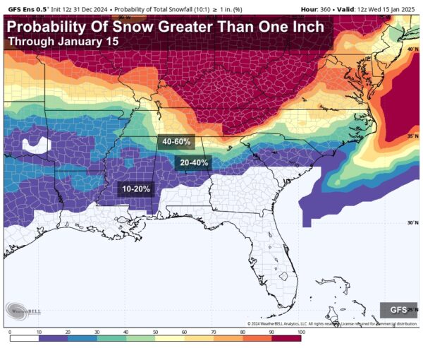
The middle of next week will be very cold and dry with highs in the 30s along with lows in the teens and 20s over northern half of the state. Then, global models show strong signals of a surface low forming in the northern Gulf of Mexico by Friday (Jan 10). New model data this morning show a drier look for Alabama, but the runs will flip and flop a number of times over the next few days. It is simply too early to know if any of the Deep South will see a winter storm, but the possibility is certainly there.
A reinforcing surge of very cold Arctic air will likely arrive around Jan 11/12… everyone will need to prepare for 1-2 weeks of very frigid air across the Deep South… See the video briefing for maps, graphics, and more details.
ON THIS DATE IN 1963: Cold Arctic air was flowing into Alabama at the surface. To the south, low pressure was in the southern Gulf of Mexico. Moisture was spreading up over the Florida Panhandle and Southeast Alabama. Up at 18,000 feet, a strong trough was rotating toward Alabama. This trough would cut off into a strong upper low over Louisiana.
This would set the stage for an unforgettable New Year’s Eve southern snow storm. The snow would begin during the morning in Birmingham and continue for the better part of the next 24 hours, into New Year’s Day.
An amazing ten inches fell at Bay St. Louis on the Mississippi Coast. Just west of there, people in New Orleans rejoiced to see four and one-half inches of snow on the ground by New Year’s morning. Everyone except Alabama football coach Bear Bryant, who knew his heavily favored Crimson Tide could handle just about anything that occurred in the Sugar Bowl against Ole Miss except for snow. (Alabama won the game by a 12-7 margin)
When it was all over, the Magic City had recorded 8.40 inches of snow, its fifth largest snowstorm ever. Florence picked up 19.2 inches of snow, a record that still stands for the state of Alabama. Huntsville measured 17.1 inches during the storm with 11 inches on the ground New Year’s morning.
Some more notes about that historic storm:
* Literally hundreds of people became stranded at New Year’s Eve parties and had to spend the night with their hosts.
* As much as 14 inches of snow fell across West Central Alabama in South Pickens and North Choctaw County.
* About 5 inches fell in North Mobile County.
* Another zone of heavier snow included 10 inches in East Alabama from about Talladega to Heflin. Eight-inch amounts were common in Central Alabama.
Look for the next video briefing here by 6:00 a.m. tomorrow…
Category: Alabama's Weather, ALL POSTS, Weather Xtreme Videos


