Quiet Weather This Week; Very Cold Air About Ten Days Out
CALMER DAYS: Alabama’s weather will be dry and pleasant today following the severe storms over the weekend. The high this afternoon will be in the mid to upper 60s for most communities; about ten degrees above average for late December. Clouds will increase tonight and tomorrow, and few small showers or sprinkles are possible with an upper trough passing through. Moisture is very limited, and many places will see no rain at all. Tomorrow’s high will be in the 60-65 degree range.
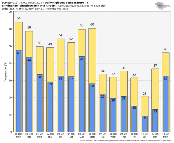
The weather will be dry and colder over the latter half of the week with highs in the low to mid 50s, along with morning lows in the 25-35 degree range.
THE ALABAMA WEEKEND: Saturday will be cold and dry with a high in the upper 40s for North Alabama… low to mid 50s for the southern counties. Clouds will increase Saturday night, and rain will likely move into the state during the day Sunday. Rain will be widespread Sunday night, possibly lingering into Monday. A few thunderstorms could be involved, but for now the air looks too stable for any risk of severe storms.
NEXT WEEK: A very cold pattern evolves over the eastern half of the U.S. with potential for a cross polar flow and the coldest air we have experienced since December 2022. Highs in the 30s for North Alabama, with lows potentially in the teens by mid-week. The big question concerns a wave and surface low in the Gulf of Mexico over the latter half of the week. Could it bring snow to Alabama? Models are all over the board (as you expect 10 days out), and it is simply too early to call.
Once this wave passes, even colder air streams into the Deep South in the January 10-12 time frame. This could bring single digit lows to North Alabama… See the video briefing for maps, graphics, and more details.
STORM SURVEYS: NWS survey teams have identified two EF-1 tornadoes in Alabama late Saturday night; one was in downtown Athens, the other in Lamar County in West Alabama. Additional survey work will be done today in Shelby, St. Clair, Lowndes, Montgomery, and Macon counties. Most of the damage across the state was due to widespread damaging winds along the line of storms.
ON THIS DATE IN 2003: The first time in five years, sections of Las Vegas received an inch or two of snow on cars, roads, sidewalks, and trees, while snow flurries fell on downtown and the Strip.
Look for the next video briefing here by 3:00 this afternoon… enjoy the day!
Category: Alabama's Weather, ALL POSTS, Weather Xtreme Videos


