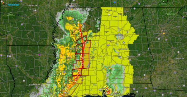
Tornado Watch in Effect For Much of Central And Northern Alabama until 4am CT: Damaging Line of Severe Storms Approaching
The SPC has issued a tornado watch (yellow shaded area) for much of the area until 4am CT Sunday morning. A line of severe storms is expected to move through over the coming hours and into the overnight time period, with widespread damaging winds, large hail, and isolated tornadoes. Some of the wind gusts could reach 75mph, and an isolated strong tornado of EF2+ intensity is possible. This line of storms is currently over eastern MS, and is blanketed with tornado warnings (red polygons). This line should reach the state line around 9pm or so, the Birmingham metro and I-65 around midnight, and clears into GA around daybreak tomorrow morning.
There may be a enhanced corridor of more widespread damaging winds across portions of Choctaw, Marengo, Hale, Sumter, Pickens, Greene, and Tuscaloosa counties, where a bow echo could develop. We will monitor this closely, and we encourage you to treat severe thunderstorm warnings tonight like a tornado warning and move to your designated shelter. These storms, regardless of if they are producing tornadoes, will have potential to produce widespread, and in some cases significant straight line wind damage, similar to that of a small tornado. We also expect numerous power outages.
Category: Alabama's Weather, ALL POSTS, Social Media


