The Waiting Game Continues for Much of Alabama; North Alabama Update
NWS Birmingham has once again made adjustments to their Severe Storms Timing graphic as stabilized air has put a hamper on supercell development over the state at this point. However, NWS Mobile just issued a Tornado Watch for their counties in Southwest Alabama and Southeast Mississippi until 2AM CST Sunday. Here is the latest update.
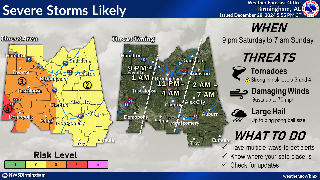
Once again, I’ll stretch it out to cover everyone in the state as far as this timing. For locations west of a line from Huntsville to Brookwood to Mobile, the threat window will be from 9PM to 1AM Sunday. East of that, the threat window will be from 11PM to 4AM Sunday. And for locations east of a line from Heflin to Alexander City to Greenville, the threat window will be from 2AM to 7AM Sunday. We could see tornadoes, some of which could be strong, long-track tornadoes in the enhanced and moderate risk locations, damaging winds up to and possibly exceeding 70 mph, and hail up to ping pong ball size in diameter.
Unfortunately, this is shaping up to be an overnight event while most people will be asleep. Get your phones charged fully before going to bed. Keep your flashlights nearby, and have your place of safety ready to go if a warning is issued for your location.
NORTH ALABAMA UPDATE: Stratiform rain continues over our area which is contaminating the environment. However, there is clearing currently over central MS and on the leading edge of this clearing in Clay and Monroe counties, we see smaller supercellular structures. There is no indication that these are surface based or severe at this point, but it shows what this environment moving in is capable of. These supercells are moving into an increasingly unfavorable/more stable environment, so the next hour should see them dissipate. Latest timing still keeps the main line reaching our area in the next 3–4 hours, on track with the timing updates done over the past 24 hours in our SitReps. I’m not overly optimistic about our environment recovering much in the next 3–4 hours behind these showers and ahead of the line, but we will be keeping an eye on that and posting in here with any updates or changes. – Katie Magee, NWS Huntsville.
Category: Alabama's Weather, ALL POSTS, Severe Weather, Social Media
About the Author (Author Profile)
Scott Martin is an operational meteorologist, professional graphic artist, musician, husband, and father. Not only is Scott a member of the National Weather Association, but he is also the Central Alabama Chapter of the NWA president. Scott is also the co-founder of Racecast Weather, which provides forecasts for many racing series across the USA. He also supplies forecasts for the BassMaster Elite Series events including the BassMaster Classic.Subscribe
If you enjoyed this article, subscribe to receive more just like it.


