The Lunchtime Update… the Calm Before the Storm
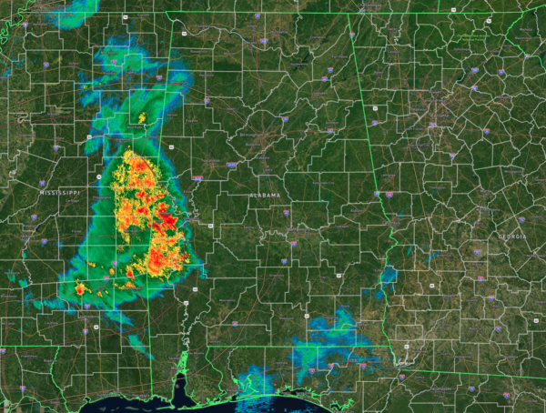
While the central and eastern parts of the state remain quiet and dry for now, storms are already invading the west and southwestern portions of the state as we have hit the lunchtime hour on this final Saturday of 2024. Rain is taking place along and west of a line from Carrollton to Demopolis to Coffeeville. For now, none of this activity is strong to severe, but that will change as we get further into the afternoon and evening hours.
Temperatures across the state were ranging from the lower 50s in the northeast to the lower 70s in the southwest. The cool spot at the moment was Gadsden at 53F, while the warm spots were Bay Minette and Selma at 72 degrees. Dewpoints are up in the 60s for pretty much everyone along and south of I-22 in the west and I-20 in the east.
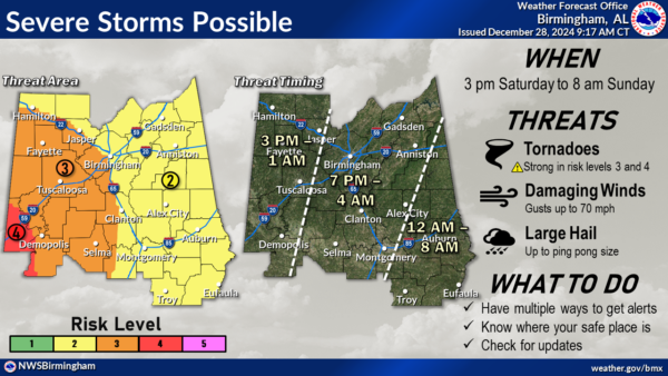
While the above image shows the counties covered by NWS Birmingham, it gives the best depiction of the timing. I’ll stretch it out to cover everyone in the state as far as this timing. For locations west of a line from Huntsville to Brookwood to Mobile, the threat window will be from 3PM to 1AM Sunday. East of that, the threat window will be from 7PM to 4AM Sunday. And for locations east of a line from Heflin to Alexander City to Greenville, the threat window will be from midnight tonight to 8AM Sunday. We could see tornadoes, some of which could be strong, long-track tornadoes in the enhanced and moderate risk locations, damaging winds up to and possibly exceeding 70 mph, and hail up to ping pong ball size in diameter.
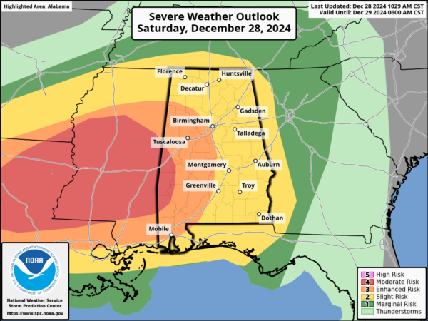
Speaking of those risk locations, the latest update from the SPC shows that now all the state has been classified in a slight risk, enhanced risk, or a moderate risk for severe storms…
• Moderate Risk: west of a line from Gainesville to Myrtlewood to just south of Chatom.
• Enhanced Risk: west of a line from Hamilton to Adamsville to just west of Clanton to Evergreen to Flomaton.
• Slight Risk: the rest of the state east of the enhanced risk.
For now, there is hardly any instability in place across the state, with the higher rates climbing quickly as you head westward over southern Mississippi, back into Louisiana, and southeastern Texas. Our shear levels are not high enough at this point for rotating thunderstorms, with those values being the highest back to our west. As time goes on this afternoon and into the evening, those values will climb, and severe weather will be possible.
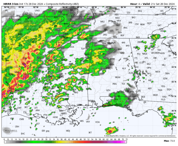
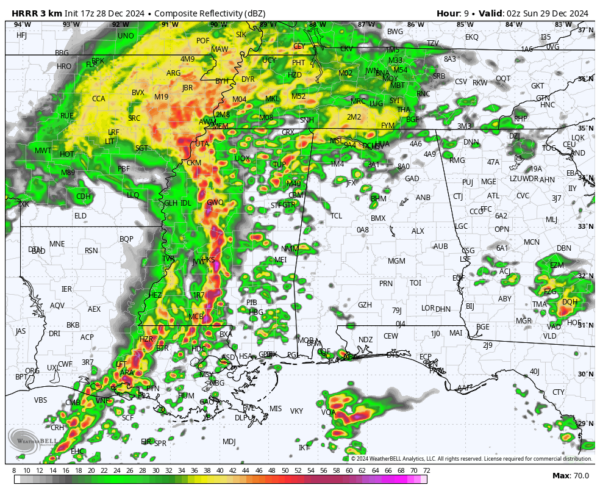
The latest HRRR run is showing rain spreading over the western parts of the state, and we also notice a lot of cells developing ahead of the main squall line that will affect us later tonight. These cells we’ll have to watch for the possibility of those stronger long-track tornadoes.
At 8PM, we see that most of the activity has lifted northward with the warm front, and most of the area will see a lull in the action before the squall line enters the state just a few hours later. However, sometimes, these models don’t pick up on convective storm development well, so we have to stay vigilant and continue to watch for supercell development over the state.
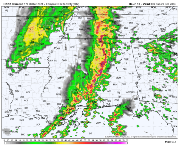
At midnight, the line will be moving into the I-65 corridor in Central Alabama, where the main threat will be from damaging winds and a smaller potential for brief, spin-up tornadoes. Hail will be possible as well within the main squall line. The higher odds of seeing tornadoes will be over the southern half of the state at this point, but a couple can’t be ruled out for the northern half.
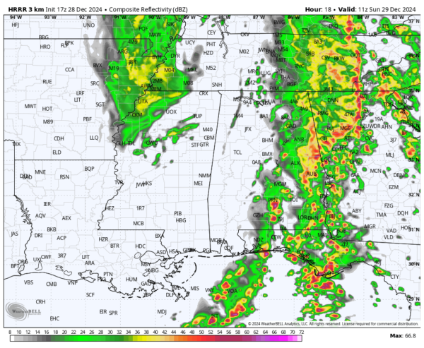
At the end of this model run at 5AM Sunday morning, the main squall line will have moved into Georgia, but we’ll continue to see showers and storms over the western half of the state. By this point, I believe the tornado risk would be nearly over, with the main threat focusing on damaging winds for the northern half of the state. However, a few tornadoes look to remain possible east of I-65 for the southeastern corner of the state for a few hours more.
It’s not too late to get prepared for today’s severe weather. Have your safety supplies and place of safety ready to go in case your location falls under a tornado or severe thunderstorm warning. Have a trusty way to receive warnings, and also have an even better backup, as in a NOAA Weather Radio. Keep your phones charged and your source of receiving warnings to wake you up if the storms hit while you sleep. We’ll have updates through the remainder of your Saturday and into your Sunday morning until the last bit of severe weather is out of the state.
Category: Alabama's Weather, ALL POSTS, Severe Weather, Social Media


