Saturday Weather Briefing: Strong/Severe Storms Expected Across Alabama Today
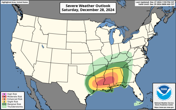
There will be a major impact severe weather event that will unfold today across the southeast stretching from eastern Texas, through Arkansas and Louisiana, through Mississippi and Alabama, up as far north as Tennessee, and ending off the day in Georgia and the extreme western parts of the Carolinas. A level 4 out of 5 moderate risk is up for the cities of Jackson, MS., Monroe, LA., Hattiesburg, MS., Alexandria, LA., and Meridian, MS. Outside of that, a level 3 out of 5 enhanced risk is up for Baton Rough, LA., Shreveport, LA., Mobile, AL., Lafayette, LA., Tuscaloosa, AL., and surrounding locations. And then a slight risk and a marginal risk is up circling around those stronger risk locations.
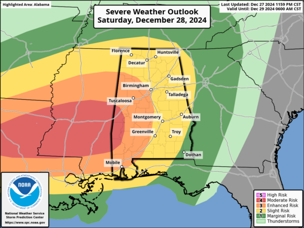
As for Alabama, everyone in the state is under some sort of risk for severe weather today.
• The Moderate Risk is up for locations along and west of a line from Geiger to Myrtlewood to Coffeeville to Chatom.
• The Enhanced Risk is up for locations along and west of a line from Hamilton to Hoover to Thorsby to Evergreen to Spanish Fort.
• The Slight Risk is up for pretty much the rest of the state, except for locations east of a line from Phenix City to Hartford (in Geneva County), which are classified in the Marginal Risk for severe storms.
THE SETUP: A strong mid-level trough is pushing eastward today, bringing with it a powerful jet stream that’s fueling this severe weather setup. At the surface, a low-pressure system is deepening over northeast Texas, with a warm front lifting northward through the Ark-La-Tex region. Scattered storms will begin developing this morning near the low, and the environment is already primed for large hail in northeast Texas.
This afternoon and evening, the severe threat will really ramp up. A moist axis of air—where dewpoints are climbing into the mid to upper 60s—will set up from southern Louisiana into western Mississippi. Combine that with a strengthening low-level jet, and we have a recipe for supercells capable of producing strong, long-track tornadoes. Areas along this moist axis, particularly across eastern Louisiana into central Mississippi, are where we could see the most dangerous storms develop.
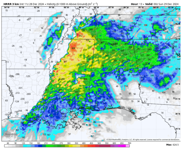
Forecast soundings are showing incredible storm-relative helicity, which is a clear indicator of a favorable environment for tornadoes.
Later this evening, a severe squall line is expected to organize and race eastward across the lower Mississippi Valley. This line will bring the threat of widespread damaging winds, potentially exceeding 70 mph, and embedded tornadoes along the leading edge. By early evening, the line will become the dominant feature, moving quickly into Alabama and the Tennessee Valley.
Overnight, the severe line of storms will continue eastward, maintaining the risk for wind damage and tornadoes as it moves through Alabama, middle Tennessee, and eventually into the southern Appalachians. While the storms will weaken somewhat overnight, the risk will not end until the system clears the region tomorrow morning.
THE TIMING: Moving from west to east, the severe weather threat will start around the 2-3PM time frame this afternoon over the west and northwestern counties, affect the central locations starting around 4-5PM, and make it into the east and southeastern parts around the midnight hour tonight. The threats should be over by 1AM Sunday in the west, by 4AM Sunday in the central locations, and by 8AM Sunday in the east.
THE THREATS: We’re talking about the potential for tornadoes, some of which could be strong and long-lasting, damaging wind gusts up to 70 mph, and large hail—potentially up to the size of ping pong balls in some of the strongest storms.
It will feel extremely muggy outside as the dewpoints will be very close to the actual temperature today, as afternoon highs are projected to make it up into the mid 60s to the mid 70s across the state.
SUNDAY WILL BE MUCH CALMER AFTER THE STORMS END: Once we get the storms out of here during the morning hours of Sunday, we can expect dry conditions with mild temperatures for late December, reaching the lower 60s to the mid 70s from north to south.
NEXT WEEK: A zonal flow will set up over the area on Monday, dropping those moisture values to much lower levels, keeping us dry with mostly sunny skies. Highs top out in the lower 60s to the lower 70s.
On New Year’s Eve, we’ll see a disturbance move across the Tennessee and Ohio River Valleys that may bring some very light rain to the north and northeastern counties of the state, but the rest of the state will be dry with partly to mostly sunny skies. Highs in the upper 50s to the lower 70s.
On New Year’s Day, temperatures will be much cooler thanks to a surface high that will be moving eastward from the west and takes a hold of the weather for the southeast. Skies will be sunny with highs in the upper 40s to the lower 60s.
On Thursday, we see these cooler temperatures staying in place as that surface high gets close to us. Skies will be sunny with highs in the mid 40s to the upper 50s.
And at the end of the forecast period on Friday, that surface high will be centered over the Alabama and Mississippi Gulf Coasts, continuing the streak of dry and cooler weather alive. Skies will be mostly sunny with highs in the mid 40s to close to 60 degrees from north to south.
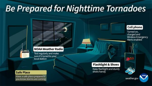
Make sure your family and friends are aware of this threat, and please share this information if you know someone in the affected areas. The time to prepare is now. We’ll continue tracking this developing situation and will bring you real-time updates as conditions evolve. Stay safe and stay tuned!
Category: Alabama's Weather, ALL POSTS, Severe Weather, Social Media, Weather Xtreme Videos


