Friday Morning Weather Briefing Video: Severe Threat Late Saturday Afternoon and Evening
FRIDAY BEGINS AN ACTIVE WEATHER PATTERN
Rain and thunderstorms will dominate the forecast for Friday as a weakening frontal system pushes across the region. Widespread rain is expected, especially along and northwest of the I-59 corridor. Some embedded thunderstorms could bring heavier downpours, but no severe weather is expected during the day. Rainfall amounts will generally range from 0.5 to 1 inch, with locally higher totals in the northwest. Highs will vary from the upper 50s in the northeast to the mid-60s in the southwest. Southeast winds will remain gusty at times, adding to the unsettled conditions.
RAIN CONTINUES FRIDAY NIGHT
Rain will taper off somewhat Friday evening, but scattered showers and isolated thunderstorms will persist through the overnight hours. A warm front lifting into southern Alabama may allow additional moisture and instability to push into the region. Lows will stay mild, ranging from the mid-50s in the northeast to the low 60s in the southwest. While the severe threat remains low Friday night, conditions will begin to prime for a more significant weather event on Saturday.
SEVERE WEATHER POSSIBLE SATURDAY
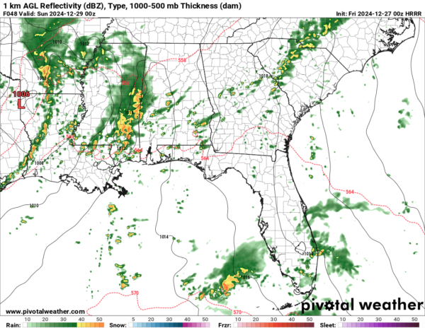
Saturday will feature an enhanced risk of severe weather as a strong storm system develops to our west. A deepening low-pressure system will bring a line of thunderstorms into Alabama late Saturday afternoon, continuing into the evening and early Sunday morning. Damaging winds and isolated tornadoes are the primary threats, especially in areas south of I-20. Rainfall totals of 1-2 inches are expected, with locally higher amounts possible. Stay alert for updates as this system approaches.
HEAVY RAINFALL AND FLOODING CONCERNS
In addition to the severe weather potential, heavy rainfall could lead to localized flooding, particularly in northeast Alabama, where surface convergence along a high-pressure wedge will enhance precipitation. Storm totals may reach 2 to 4 inches in some areas, with isolated higher amounts possible. Low-lying and urban areas will be most vulnerable to flooding impacts.
STORMS CLEAR EARLY SUNDAY
The line of storms will push eastward early Sunday morning, with rain tapering off by midday. Clearing skies are expected in the afternoon, allowing for some sunshine. Highs will remain mild in the mid-to-upper 60s, providing a welcome break after the active weather.
A QUIET START TO THE WEEK
Monday brings a quieter weather pattern with mostly sunny skies and highs in the mid-to-upper 60s. This brief reprieve will be short-lived, as another system moves in Monday night into Tuesday, bringing additional rain chances.
ANOTHER FRONT EARLY TUESDAY
A fast-moving cold front will bring scattered showers Monday night into early Tuesday. Rainfall amounts will be light, and no severe weather is anticipated with this system. Temperatures will remain mild, with highs in the 60s before cooler air filters in by midweek.
TURNING COOLER FOR NEW YEAR’S EVE
By Wednesday and New Year’s Eve, highs will drop to near 50 degrees under partly cloudy skies as cooler air settles into the region. Expect overnight lows in the upper 30s, providing a chilly start to 2025.
BEACH FORECAST
High rip current risks will persist at the beautiful beaches of Alabama and Northwest Florida through Sunday afternoon, with surf heights of 3 to 5 feet. Rain and thunderstorms are likely Friday and Saturday, but improving conditions are expected by Sunday afternoon. Highs at the beach will be in the upper 60s to near 70, with lows in the low 60s.
STAY WEATHER AWARE THIS WEEKEND
Severe storms and heavy rain are expected to impact the region late Saturday into early Sunday. Review your emergency plans, ensure your weather alerts are working, and stay tuned for updates as this evolving system approaches.
ON THIS DATE IN 1996
Dense fog in the Tampa Bay area caused a series of chain reaction accidents on the soaring Sunshine Skyway Bridge, involving 50 vehicles. One person was killed and 24 injured. The 1280-foot span across the mouth of Tampa Bay was closed in both directions.
Category: Alabama's Weather, ALL POSTS, Severe Weather, Social Media


