Thursday Afternoon Weather Briefing Video: Severe Weather Risk Upgraded for Saturday
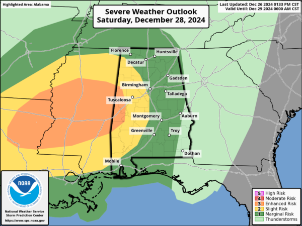
The breaking news is that the Storm Prediction Center did update their severe weather outlook for the day three period which includes Saturday and Saturday night. Western Alabama is now in an enhanced risk (level 3 out of 5) and a slight risk (level 2 out of 5) extends over to I-65. Dust off your severe weather safety plan and test you weather warning receiving methods.
DREARY THURSDAY
Today has been a dreary day across Alabama with lots of clouds and rain. Temperatures have struggled to rise in areas that saw more rainfall, and a few spots never made it out of the 40s with the cloud and rain. But most folks are in the 50s late this afternoon. We stay mostly dry overnight, with just cloudy skies, and lows dropping into the upper 40s North to lower 50 Central.
BIRMINGHAM BOWL DAY
Tomorrow will be a festive day with the Birmingham Bowl at Protective Stadium. Tailgating will kick off at 10 a.m. with gates opening at 1 p.m. Kick off is at 2:30 p.m. as Vandy and Georgia Tech do battle in a very competitive SEC/ACC matchup. Storms over Texas and Louisiana will weaken overnight and move into West Alabama by morning. We will deal with some showers and embedded thunder through the morning hours. The line will get some renewed energy by early afternoon as the heating of the day kicks it up a notch and we could deal with some lightning for the game. Officials are ready in case that happens. Highs on Friday will be in the lower 60s on average. Southeasterly winds will gust to 25 mph at times.
SATURDAY
Saturday will be cloudy, mild, and breezy. It will feel much more humid as dewpoints reach the middle 60s. High temperatures will range between the lower and middle 60s over North and Central Alabama. There will be a few showers during the day, but the main storms will reach Northwest Alabama by 4-5 p.m. By that time, severe weather will have been ongoing in Mississippi for a few hours. These storms will have a decent amount of instability and a tremendous amount of low level shear, which is the recipe for a few cold season spin up tornadoes. At least two rounds of storms will push into West Alabama during the evening.
SPC OUTLOOK
This is the first Day Three Enhanced Risk issued by the SPC for Alabama in December…
The orange area is the enhanced risk area (level 3 out of 5) and where the best chance for tornadoes will be Saturday afternoon and evening. The slight risk (level 2 out of 5) though extends over to the I-65 Corridor. The severe weather should be weakening after 10 p.m.
SUNDAY AND BEYOND
Expect the rain to be ending Sunday morning with some clearing by afternoon. Temperatures will still be mild, with highs in the middle 60s. Check the video for all the details including some interesting news for snow fans!
Next video will be posted by tomorrow morning. Have a great evening!
Category: Alabama's Weather, ALL POSTS, Severe Weather, Social Media


