Thursday Weather Briefing Video: Severe Weather Threat Saturday
As we head into Thursday, the weather pattern remains active, setting the stage for a dynamic finish to the week. High clouds will continue to stream into Alabama today, with thicker mid-level clouds spreading into the western and southwestern parts of the state. While isolated showers are possible west of Interstate 65, most of the region will stay dry. Temperatures will range from the mid-50s in the northeast to the mid-60s in the southwest. Southeastern winds will remain light but persistent, adding a touch of warmth to the day.
THURSDAY NIGHT INTO FRIDAY
Cloud cover will increase further Thursday night as a more robust system approaches from the west. Light rain may begin developing late Thursday night in areas west of I-65, though totals will remain light. Lows will range from the mid-40s in northeast Alabama to the lower 50s in the southwest. Southeastern winds will strengthen slightly overnight, marking the beginning of an unsettled period. By Friday morning, expect an increase in rain chances, particularly across western Alabama.
FRIDAY’S TRANSITIONAL WEATHER
Friday brings the first significant wave of rain as a weakening system approaches the state. A band of moderate rain will spread from west to east during the day, with the heaviest rainfall likely in northwest Alabama. Highs will be in the upper 50s to lower 60s. Though thunderstorms are not expected, gusty southeast winds of 15-20 mph, with occasional gusts up to 25-30 mph, will be noticeable throughout the day. The Birmingham Bowl in the afternoon may experience scattered showers, but heavy rain should hold off until later in the day.
A STORMY SATURDAY AHEAD
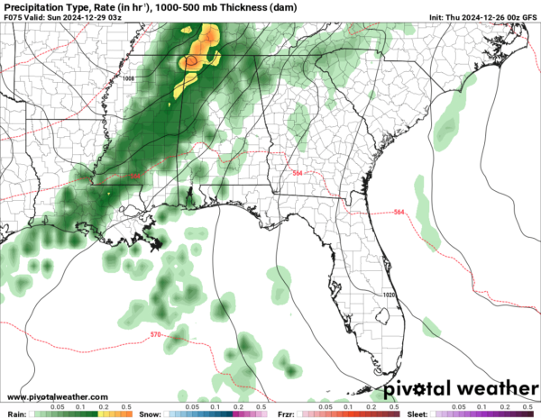
Saturday is shaping up to be the most active day of the week as a stronger system moves in. Rain and embedded thunderstorms will overspread the state, especially during the afternoon and evening hours. With dew points climbing into the mid-60s, a line of storms could form by Saturday night, bringing heavy rain and gusty winds. Severe weather remains a lower-end threat due to limited instability, but parameters will be monitored closely for any changes. Rainfall totals between 1 and 3 inches are likely through Sunday morning, with localized higher amounts in northwest Alabama.
SUNDAY CLEARING TREND
Showers will linger Sunday morning, especially in eastern parts of the state, but clearing skies will gradually take over by the afternoon. Highs will remain mild, ranging from the upper 50s to the mid-60s, with a return to more tranquil weather conditions. Sunday will bring a welcome respite before another system takes aim at the region early next week.
EARLY NEXT WEEK OUTLOOK
The fast-paced pattern continues into early next week. A weaker system may bring scattered showers on Monday night into Tuesday morning, but rainfall amounts look light compared to this weekend’s activity. Temperatures will remain above average for late December, with highs in the upper 50s to mid-60s.
UPDATED BEACH FORECAST
For those along the Alabama and Northwest Florida beaches, Thursday will feature mostly cloudy skies with highs in the upper 60s. Rip current risks will increase to moderate as surf heights reach 3 to 4 feet. Thursday night into Saturday will see high rip current risks as surf heights rise to 3 to 5 feet. Showers and isolated thunderstorms are likely Saturday, with clearing skies expected by Sunday afternoon. Stay updated on beach conditions as this active weather pattern unfolds.
ON THIS DATE IN 1947
New York City’s “Big Snow”. New York City recorded its third greatest 24-hour snowfall. In a 24-hour period ending on the 27th, Central Park in New York, New York, received 26.4 inches, while 32 inches fell on some suburbs. Because the storm was not accompanied by strong winds, it was not a blizzard. Holiday travel was brought to a standstill. 27 deaths occurred as a result of the storm. Snow removal of the estimated 10 million tons of snow cost over $8 million. 19 inches of snow fell in just six hours at White Plains NY.
Category: Alabama's Weather, ALL POSTS, Severe Weather


