Cooling Trend Ahead; Sub-Freezing Lows By The Weekend
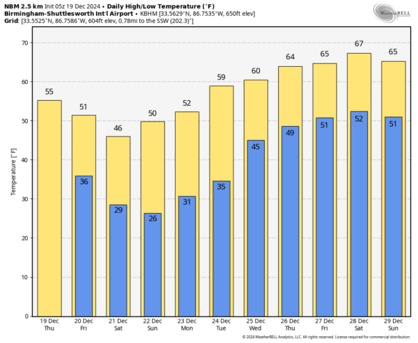
COOLER: Cooler, drier air is rolling into Alabama this morning. Morning clouds will give way to afternoon sunshine; highs will be in the 50s over the northern half of the state, with low to mid 60s for South Alabama. The weather stays dry through Sunday, and the cooling trend continues. By Saturday temperatures will hold in the 40s over the northern half of the state, and a freeze is likely deep into South Alabama by early Sunday morning.
CHRISTMAS WEEK: Dry weather will likely continue Monday and Tuesday with a warming trend; highs will be in the mid to upper 50s. We will continue to mention some risk of some rain on Christmas Day, but amounts should be very light, and it certainly won’t rain all day. The high Wednesday will be in the 60-65 degree range for most communities.
Some risk of showers (and possibly a few thunderstorms) will likely continue Thursday and Friday, and highs remain in the 60s. See the video briefing for maps, graphics, and more details.
RECORD TIED: The high in Montgomery yesterday was a balmy 79 degrees… that tied the record high for December 18, last set in 1984. Birmingham’s official high was 75, just missing the record high of 76, set in 1908 and 1984.
ON THIS DATE IN 2009: Snowfall totals from 1 to 2 feet were commonplace in what will go down as one of the biggest snowstorms in history on the East Coast and the first of four snowstorms for the Mid-Atlantic during the winter of 2009-10. The 15 inches of snow measured at Reagan International Airport on Dec. 19th was the third-highest daily snowfall on any calendar day at Washington, DC, since snowfall records began in 1884. The total storm snowfall of 16.4 inches on Dec 18-19 2009 marks the 6th highest two-day snowfall record for Washington, DC putting it just below the second President’s Day storm in 2003 and ahead of the Jan 1996 storm.
Look for the next video briefing here by 3:00 this afternoon… enjoy the day!
Category: Alabama's Weather, ALL POSTS, Weather Xtreme Videos


