Sunday Weather Briefing: Rain on the Horizon
NO VIDEO THIS MORNING BECAUSE OF WEATHER CONFERENCE TRAVEL
Changes are in store with wet weather and some heavy rain coming to Alabama early in the coming week.
SUNNY START, CLOUDY FINISH
A calm and dry start to Sunday is on tap for Alabama, with high pressure still influencing the region early in the day. Morning temperatures will be chilly, starting in the mid to upper 30s in most areas before warming under increasing cloud cover. As the day progresses, high clouds will thicken ahead of our next weather system, signaling changes on the horizon.
RAIN RETURNS TO THE FORECAST
The approaching system, a vigorous shortwave moving out of the Southern Plains, will increase rain chances across the northwest half of Alabama Sunday afternoon. While most of the rain will be light, a few areas could see up to 0.05 inches before the evening hours. Rain coverage will expand overnight into Monday, with some evaporative cooling keeping temperatures in check late Sunday afternoon.
LOOKING AHEAD: A WET START TO THE WEEK
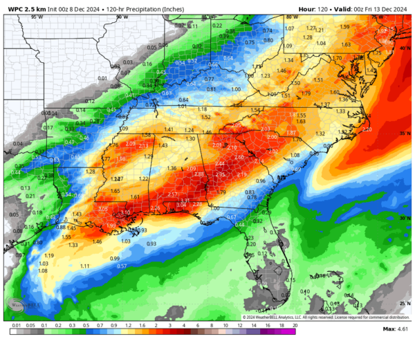
Sunday Night Through Monday: Widespread rain develops, with totals of 1-3 inches possible through early Wednesday. Southern portions of Central Alabama may see isolated thunderstorms if a warm front lifts far enough north by Tuesday.
Tuesday: Rain diminishes from northwest to southeast, though showers and a few storms remain possible near the I-85 corridor. Highs will range from the lower 60s north to the low 70s south.
Wednesday Through Friday: Cooler and drier air returns as a sharp cold front sweeps through Wednesday morning. Lingering showers southeast of I-59 will taper off quickly. Highs will drop to the mid-40s to low 50s midweek, with morning lows near freezing by Thursday and Friday.
BEACH FORECAST: ALABAMA AND NORTHWEST FLORIDA
A pleasant day at the beach is expected Sunday, with mostly sunny skies giving way to increasing clouds later in the afternoon. Highs will climb into the upper 60s near the Alabama coast and around 70°F in the Florida Panhandle. Water temperatures are in the upper 50s, and surf heights will remain around 1 foot. The rip current risk is low, making it safer for beachgoers, but always exercise caution near groins and piers. Winds will shift to the southeast at 5-10 mph, enhancing the mild conditions. Prepare for rain chances to increase late Sunday night into Monday.
WEATHERBRAINS PODCAST RECAP
This week’s WeatherBrains featured a deep dive into the NWS Buddy System and its impact on mental health in the weather community. Tune in to hear from Tim Brice, Marissa Pazos, and Laura Belanger on this critical topic. Next up, we’ll be talking about the Warn on Forecast System, the next step in the evolution of the severe weather warning process.
ON THIS DAY IN WEATHER HISTORY: 2017
A moist southwesterly flow up and over a cold airmass in place over Alabama caused widespread heavy snow across the Central part of the state. Warm surface temperatures prevented the roads in areas which received up to 3 inches from becoming snow-packed, they remained mostly wet. But in some areas, especially East Central Alabama east of Birmingham, 6-12 inches of heavy wet snow did cause travel problems. The heavy, wet snow brought down tree branches in many area, which resulted in power outages. It took up to two days in some areas to restore power.
FINAL THOUGHTS
Keep an eye on the skies as rain moves in Sunday afternoon. Prepare for a wet start to the week, but relief is on the way with colder, drier air returning by midweek. As always, we’ll keep you updated with the latest developments here on AlabamaWX.com!
Category: Alabama's Weather, ALL POSTS, Social Media


