We’ll Be Transitioning from Meteorological Fall to Meteorological Winter This Weekend, & It Will Feel Like It Too
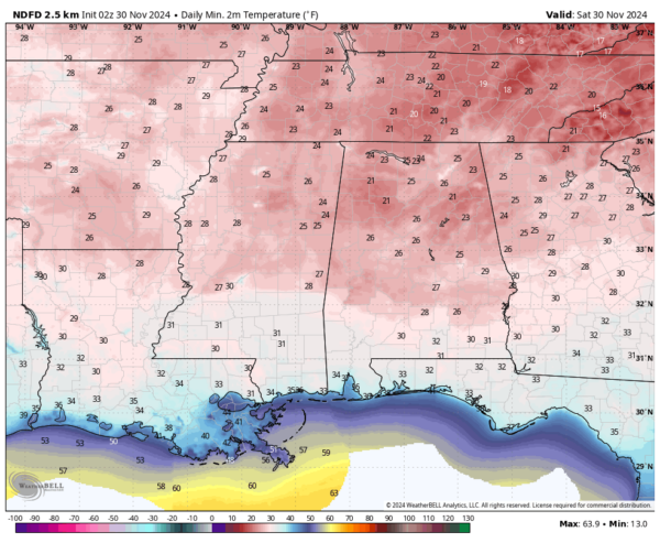
After waking up with a widespread freeze this morning with morning lows starting off in the lower 20s to the upper 20s in North/Central Alabama, and in the upper 20s to the mid 30s in South Alabama, today’s highs will top out in the upper 40s in the northeast to the upper 50s with mostly sunny skies and winds out of the northwest.
I have heard about some big game that is happening down in Tuscaloosa involving some tigers wearing orange and blue attempting to spoil a chance at the playoffs for the crimson-wearing home team. That’s right, the Iron Bowl is set to kick off at 2:30PM CT at Saban Field at Bryant-Denny Stadium, and temperatures will be in the lower 50s at the opening whistle and will be dropping into the lower 40s by the final snap. Winds will be light and skies will be sunny.
Not much change to our weather for the first day of December and the first day of Meteorological Winter on Sunday. We’re looking at another day with mostly sunny skies and highs slowly warming into the lower 50s to the lower 60s.
We’ll have another impulse of cold air move into the state on Monday that will push those temperatures down even further than Black Friday. Afternoon highs will range from the lower 40s in the north to the mid to upper 50s in the south. The big story is that overnight lows are projected to fall into the upper 10s to the lower 30s right as the sun starts to rise on Tuesday morning.
Tuesday’s highs will actually be slightly cooler in some locations, especially down in South Alabama. We continue the dry streak with highs in the lower 40s to the mid 50s.
Winds will shift more out of the west and west-northwest at the 500mb levels on Wednesday, and that will allow for temperatures to begin to rise. As that happens, we also see a disturbance start to form off to our west and southwest. A surface high located over the Gulf Coast of Western Florida will help send that disturbance in our direction, but it will not arrive here until Thursday. Clouds will be on the increase through the day, and highs will top out in the upper 40s to the mid 60s.
Scattered showers will be possible on Thursday across the area, with the higher chances across the central and southern portions of the state. However, projected rainfall totals at this point look meager at best. Highs in the mid 50s to the upper 60s.
And at the end of the forecast period on Friday, rain chances will spread out across the entire state, but it is not a guarantee that everyone will see raindrops in their location. And if you receive rain, don’t expect totals to be all that much as well. Highs in the lower 50s to the lower 70s.
Today is the last day of the Atlantic Hurricane Season, and the great news is that we are closing off the season on a quiet note. It is currently quiet across the Atlantic Ocean, the Gulf of Mexico, and the Caribbean Sea, and no new systems are expected to develop within the next seven days. After today, unless a rogue system develops off-season, the next tropical update will be on June 1st, 2025.
Category: Alabama's Weather, ALL POSTS, Social Media, Weather Xtreme Videos


