A Near Picture-Perfect Fall Weekend Across The State
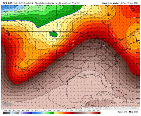
A VERY NICE FALL SATURDAY: With a strong ridge in place over the eastern half of the country, and a very deep trough over the southwest, our flow at 500mb will be out of the southwest. After a chilly start with early morning lows in the upper 30s to the mid 40s, those daytime highs will top out in the upper 60s to the lower 70s under mostly sunny skies.
FOOTBALL WEATHER: Auburn vs. LA-Monroe (11:45 AM CT Kickoff, Jordan-Hare Stadium)
Expect a bright and sunny sky throughout the game. Temperatures will start in the mid-60s at kickoff and rise to near 70 degrees by the final whistle.
Alabama vs. Mercer (1:00 PM CT Kickoff, Bryant-Denny Stadium)
Sunny conditions will prevail in Tuscaloosa as well. Temperatures during the game will range from 68 to 71 degrees—perfect football weather!
UAB at Memphis (7:00 PM CT Kickoff, Simmons Bank Liberty Stadium)
For the Blazers’ evening game in Memphis, the sky will be clear with crisp conditions. Temperatures will start in the low 60s at kickoff and drop into the low 50s by the fourth quarter.
SUNDAY’S NOT TOO SHABBY EITHER: Ridging continues to hang out over the southeast, keeping our weather very nice. We’ll have mostly sunny skies with highs in the upper 60s to the mid 70s.
NEXT WEEK STARTS OFF NICE & DRY: We’ll get one more nice day across Central Alabama on Monday before a cold front moves into the area on Tuesday. Skies will be mostly sunny through the daylight hours, with clouds moving in late. Some locations could see some shower activity around or just after midnight. Highs in the lower to mid 70s.
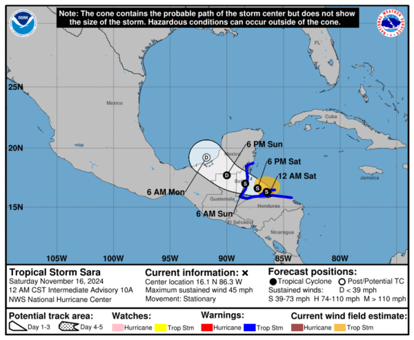
RAIN RETURNS FOR TUESDAY & PARTS OF WEDNESDAY: The cold front will move through the area on Tuesday and into the early morning hours on Wednesday, that will bring solid rain chances to the area. We also have the potential of the remnants of Tropical Storm Sarah moving up over the Gulf Coast. If that plays out, we’ll have scattered showers and storms over the northern half, with rain and storms likely over the south. Highest coverage looks to take place during the afternoon and evening. Highs in the upper 60s to the mid 70s.
We’ll have another low headed toward the area and moving across the northern portions of the state on Wednesday that will bring another chance of showers. Any showers look to stay over the Tennessee Valley and north, while the rest of the state will remain dry with mostly sunny skies. Cold air will begin to be pulled into the area, as highs top out in the lower 60s to the lower 70s.
A BIG COOLDOWN TO END THE WORK WEEK: With a deep trough located over to our north and northeast, our mid-level flow will be out of the northwest, with it being the strongest on Thursday. We’ll see daytime highs only reach the 50s, while 30s to lower 40s can be expected before Thursday’s sunrise. Widespread 30s can be expected across the entire area to start the day on Friday, and frost advisories will most likely be issued. It will remain cool and dry through the day with highs in the lower 50s to right around 60.
THE TROPICS: Tropical Storm Sara remains largely unchanged, maintaining deep convection north of its center and a tighter band to the west, with winds holding steady at 50 mph. The storm has stalled as of Friday night but is expected to slowly drift westward before moving toward Belize late Sunday as a ridge strengthens to its north. No significant intensification is forecast due to Sara’s broad structure and possible land interaction, with the system likely weakening into a remnant low near the southern Yucatán Peninsula. The primary concern remains catastrophic flash flooding, with significant rainfall already reported along the north coast and mountainous regions of Honduras. The rest of the tropics are quiet.
SEVERE WEATHER SAFETY
Weather can be unpredictable, often catching us off guard with sudden changes. From thunderstorms and tornadoes to flash floods, being prepared can truly save lives. Alabama’s varied climate brings its share of severe weather, making it crucial for everyone to have a solid safety plan in place. For valuable tips on staying safe when severe weather threatens, check out our Severe Weather Safety Guide. Stay ready, stay safe!
BEACH FORECAST
Visit our Beach Forecast Center to get the latest weather and rip current forecasts for beaches from Fort Morgan to Panama City. This page allows you to select forecasts tailored to your destination, ensuring you have the most accurate and relevant information for your beach plans. Stay informed and safe on your coastal getaway!
ADVERTISE ON THE BLOG
Don’t miss this opportunity! Let us create a customized package tailored to the unique needs of your organization. Our solutions are creative, flexible, and competitively priced. For more information or inquiries, please contact Bill Murray at (205) 687-0782.
E-FORECAST SIGN UP
Get the Alabama Weather Blog’s comprehensive Seven-Day Forecast delivered straight to your inbox twice daily. Known as the most detailed forecast available in Central Alabama, our service ensures you’re always informed and prepared. Subscribe now and gain access to this valuable resource for free!
Category: Alabama's Weather, ALL POSTS, Social Media, Tropical, Weather Xtreme Videos


