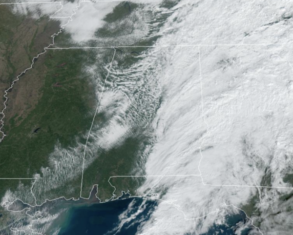
Midday Nowcast: Clearing Sky Through the Afternoon
The rain is exiting east into Georgia this afternoon and we are seeing the sky clear from west to east through Alabama today. Temperatures this afternoon are in the generally in the 60s. Tonight with a clear sky, temperatures will fall into the 40s by early tomorrow morning.
BIRMINGHAM ALMANAC: For November 14th, the average high for Birmingham is 65° and the average low is 43°. The record high is 82° set in 1955, while the record low is 23° set in 2014. We average 0.15” of precipitation on this date, and the record value is 4.43” set in 1929.
ACROSS THE USA: A storm system is bringing heavy snow, gusty winds and blizzard conditions to southwest Alaska. Coastal rain and higher elevation snowfall will continue over the Pacific Northwest and northern California through the day. In the East, a coastal storm is expected to bring a period of gusty winds, enhanced rainfall and thunderstorms from the Carolinas to the Mid-Atlantic states tonight into Friday
FRIDAY AND THE WEEKEND: Tomorrow and the weekend will feature phenomenal fall weather across Alabama with sunny pleasant days and clear chilly nights. Highs tomorrow will be in the 60s, and likely lower 70s both Saturday and Sunday. Lows drop into the 40s, and some colder spots over North Alabama could reach the 30s early Saturday morning.
FOOTBALL WEATHER: A perfect night for high school playoff games tomorrow night. A clear sky with temperatures falling through the 50s.
Saturday, Auburn hosts LA-Monroe at Jordan-hare Stadium (11:45a CT kickoff)… expect a sun filled sky with temperatures rising from the mid 60s at kickoff, to near 70 by the final whistle.
Saturday, Alabama hosts Mercer (1p CT kickoff) at Bryant-Denny Stadium/Saban Field. The sky will be sunny with temperatures in the 67-70 degree range.
UAB plays at Memphis Saturday night (7p CT kickoff). The sky will be clear with temperatures falling from the low 60s at kickoff into the low 50s by the fourth quarter.
INTO NEXT WEEK: The quiet pattern looks to continue into at least the first half of next week as the weather stays dry and seasonable. However, a dynamic weather system will bring some risk of rain and thunderstorms to the Deep South by Thursday ahead of a cold front. Behind the front, much colder air will blow into Alabama as highs will fall into the 50s, while lows return to the 30s. Also next week, we will keep an eye on tropical mischief in the Gulf.
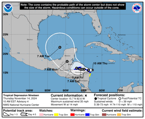
SOON TO BE SARA: Tropical Depression 19 is moving toward the west near 14 mph. This motion should continue through today, bringing the center near the coast of eastern Honduras. The system is expected to meander near the northern coast of Honduras late Friday and through the weekend. Early next week it is expected to move north across the Yucatan peninsula, moving into the Gulf of Mexico early next week, and then track east towards the Florida Peninsula. Maximum sustained winds are near 35 mph with higher gusts. Some strengthening is forecast and the system is forecast to become a tropical storm later today. The estimated minimum central pressure is 1004 mb (29.65 inches).
It is too soon to determine what impacts the system could bring to portions of the eastern Gulf of Mexico, including Florida, the Florida Keys, and Cuba during the middle portion of next week. Sara could dissipate inland over the Yucatan peninsula of Mexico, but it if survives we will need to keep a close eye on it in the southern Gulf. Most global model ensemble members show a weak low/rainmaker impacting the Florida Peninsula by the middle of next week.
WORLD TEMPERATURE EXTREMES: Over the last 24 hours, the highest observation outside the U.S. was 109.2F at Julia Creek, Australia. The lowest observation was -67.0F at Dome A, Antarctica.
CONTIGUOUS TEMPERATURE EXTREMES: Over the last 24 hours, the highest observation was 92F at Ingleside, TX The lowest observation was 4F at Grand Lake, CO.
Category: Alabama's Weather, ALL POSTS, Social Media


