Sunday Weather Briefing: Rainy Start; Temperatures Will Climb to Mid/Upper 70s
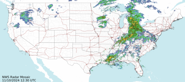
TODAY’S WEATHER SETUP: This morning, showers are making their way into the state from the west. Much of the northern part of the state will dry up by lunchtime, but chances for rain linger in the south throughout the day. A cold front will pass over the area later this evening. Southeast winds will be 5 to 10 mph. This afternoon, high temperatures will climb to the mid to upper 70s across the state.
NEXT WEEK OUTLOOK: Rain chances are possible for the northern half of the state early Monday morning. By lunchtime, the only rain in the state should be south near the coast. High temperatures across the state will be in the mid to upper 70s. Expect dry weather Tuesday and Wednesday morning with highs in the mid 70s, which continue to be above average for mid-November in Alabama. However, Wednesday afternoon, a strong cold front will dive south. The front will bring the chance of rain and storms, and then much cooler weather for Thursday. Then, we will dry back off again for Friday and next weekend.
WHAT TO EXPECT NEXT WEEKEND: We should see a dry weekend next week thanks to an area of high pressure that will build into the region. High temperatures will drop into the 60s for the north, and lower 70s for the south.
BEACHCAST: If you’re heading to the beautiful beaches of Alabama and northwest Florida, expect rain today with temperatures in the upper 70s and water temperatures in the low-70s. A high rip current risk is present today dur to Rafael, so exercise caution when entering the water. Surf heights will range from 3 to 5 feet, with breezy southeast winds at 10 to 15 mph.
IN THE TROPICS: Rafael has weakened to a tropical storm, and is expected to remain over the Gulf as it continues to weaken into a broad area of low pressure. Right now, winds are only at 40 mph, and the pressure has increased to 1003 mb.
Also, in the Southwestern Atlantic, disorganized showers and thunderstorms continue in association with a trough of low pressure that extends from the central Caribbean Sea northeastward across Hispaniola and into the southwestern Atlantic. Some gradual development of this system is possible during the next week. Regardless of development, locally heavy rains are possible across the Virgin Islands, Puerto Rico, Hispaniola, and the southeastern Bahamas through Saturday. Formation chance through 7 days…low…10 percent. The next name up is Sara.
NATIONALLY: Widespread snow, with periods of heavy snowfall rates, and gusty winds continue across the northwest US today. A high pressure system over Colorado will keep much of the western portion of the country dry over the next day or so. In the Northeast, rain will fall today with some pockets of snow to the far north.
ON THIS DATE IN 2002: The second-largest November tornado outbreak on record over the eastern United States occurred during the Veterans Day weekend of November 9-11th, 2002. Seventy-six tornadoes were reported in seventeen states. Of the 76 tornadoes, almost one out of every six was a killer, resulting in 36 fatalities.
Category: Alabama's Weather, ALL POSTS, Social Media


