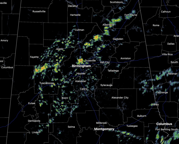
Midday Nowcast: Umbrella Alert! Rain and Storms at Times; Rafael Gaining Strength
RAIN/STORMS AT TIMES: Today through Friday, scattered showers and storms are expected each day, rain distribution will not be very even due to the scattered nature of the activity. The chance of any one spot seeing rain will be in the 40-80 percent range. We will continue to see more clouds than sun and temperatures will remain above average with highs mainly in the upper 70s.
BIRMINGHAM ALMANAC: For November 6th, the average high for Birmingham is 68° and the average low is 46°. The record high is 82° set in 1938, while the record low is 24° set in 1976. We average 0.14” of precipitation on this date, and the record value is 1.57” set in 1989.
FRIDAY NIGHT LIGHTS: Scattered showers are possible for the high football playoff games across Alabama Friday night, but nothing heavy or widespread. The sky will be mostly cloudy with temperatures falling through the 70s.
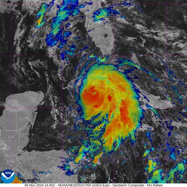
ACROSS THE USA: Strong Santa Ana winds will bring critical to extremely critical fire weather conditions to portions of California today into Friday. Rafael has strengthened into a hurricane and is expected to enter the Gulf of Mexico by Thursday. Tropical Storm Warnings have been issued for parts of the Florida Keys. It is too soon to determine any northern Gulf Coast impacts.
WEEKEND WEATHER: The overall pattern won’t change much through the weekend and we will maintain the risk of showers with some storms at times both Saturday and Sunday, but again, rain distribution won’t be very even. Average rain amounts from today through the weekend will be around one inch, with some spots receiving more, while others spots see less. The warm weather will persist as temperatures will remain in the upper 70s to lower 80s. Rafael in the Gulf will be a non-factor this weekend for Alabama as it will remain to the south of Alabama.
FOOTBALL WEATHER: Saturday UAB will host UConn at Protective Stadium in downtown Birmingham (1:30p CT kickoff); expect a mix of sun and clouds with a passing shower possible during the game. Temperatures will hover in the 78-81 degree range.
Alabama will be in Baton Rouge to take on LSU Saturday night (6:30p CT kickoff). The sky will be cloudy with a few periods of rain possible during the game… temperatures will fall slowly through the 70s.
NEXT WEEK: The weather trends drier as the upper ridge rebuilds; much of the week will be rain-free with highs in the 70s, which will continue to be well-above average for mid-November in Alabama.
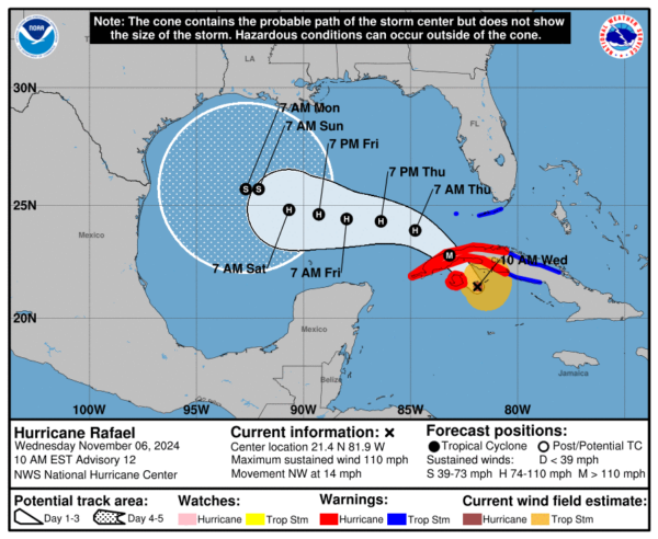
HURRICANE RAFAEL: At 1000 AM EST, the center of Hurricane Rafael was located near latitude 21.4 North, longitude 81.9 West. Rafael is moving toward the northwest near 14 mph. A general northwestward motion is anticipated over the next day or so, followed by a gradual west-northwestward turn in the Gulf of Mexico.
On the forecast track, Rafael is expected move near or just east of the Isle of Youth during the next few hours, and make landfall in western Cuba later today. Rafael is forecast to move into the southeastern Gulf of Mexico tonight. Maximum sustained winds have increased to near 110 mph with higher gusts. Additional strengthening is expected, and Rafael is forecast to be a major hurricane when it makes landfall in Cuba later today. Rafael is forecast to weaken over Cuba but is expected to emerge into the southeastern Gulf of Mexico as a hurricane. Hurricane-force winds extend outward up to 15 miles from the center and tropical-storm-force winds extend outward up to 115 miles. The estimated minimum central pressure is 960 mb (28.35 inches).
We are getting much better model agreement this morning, and the NHC track has been adjusted south and westward. Rafael will encounter strong winds aloft, dry air, and cooler sea surface temperatures by the weekend which should induce rapid weakening, and there is a good chance it will be sheared apart before reaching the U.S. coast.
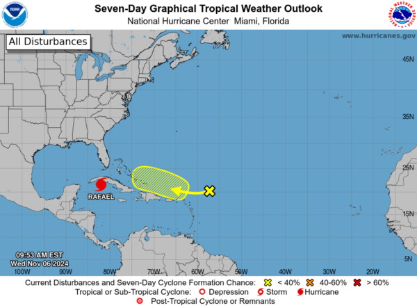
Also, in the Southwestern Atlantic, a trough of low pressure is producing an area of disorganized showers and thunderstorms several hundred miles east-northeast of the Leeward Islands. This system is expected to move generally westward during the next few days, and an area of low pressure could form near the northern Leeward Islands tonight or Thursday. Afterward, some gradual development of this system is possible toward the end of the week and into the early part of the weekend while it moves near or to the north of the Virgin Islands and Puerto Rico, and approaches the Southeast Bahamas. Formation chance through 7 days…low…30 percent.
WORLD TEMPERATURE EXTREMES: Over the last 24 hours, the highest observation outside the U.S. was 113.2F at Port Hedland Airport, Australia. The lowest observation was -74.0F at Vostok, Antarctica.
CONTIGUOUS TEMPERATURE EXTREMES: Over the last 24 hours, the highest observation was 89F at numerous locations across the Deep South. The lowest observation was -5F at Calpet, WY.
Category: Alabama's Weather, ALL POSTS, Social Media, Tropical


