Hurricane Rafael Update: Rapid Intensification Underway as System Approaches Cuba
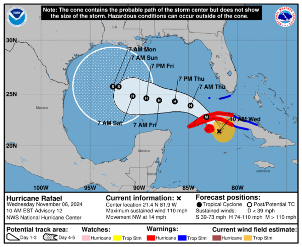
Rafael is now a strong category 2 hurricane, with winds at 110 mph and a pressure of 960 mb. This system is now much stronger than it was just 12 hours ago, and it is expected to continue intensifying as it approaches Cuba.
Here is a look at Rafael on satellite:
There is now a clear eye in the center of the storm, as well as a double eyewall structure.
Here are the current stats from the NHC:
SUMMARY OF 1000 AM EST…1500 UTC…INFORMATION
LOCATION…21.4N 81.9W
ABOUT 60 MI…95 KM ESE OF THE ISLE OF YOUTH
ABOUT 130 MI…205 KM SSE OF HAVANA CUBA
MAXIMUM SUSTAINED WINDS…110 MPH…175 KM/H
PRESENT MOVEMENT…NW OR 320 DEGREES AT 14 MPH…22 KM/H
MINIMUM CENTRAL PRESSURE…960 MB…28.35 INCHES
SUMMARY OF WATCHES AND WARNINGS IN EFFECT:
A Hurricane Warning is in effect for…
* Cuban provinces of Pinar del Rio, Artemisa, La Habana, Mayabeque,
Matanzas, and the Isle of Youth
A Tropical Storm Warning is in effect for…
* Cuban provinces of Villa Clara, Cienfuegos, Sancti Spiritus,
and Ciego de Avila
* Lower and Middle Florida Keys from Key West to west of the
Channel 5 Bridge
* Dry Tortugas
Rafael is expected to make landfall later today, then move into the Gulf of Mexico overnight. The NHC is expected that this system will develop into a major hurricane by the time it makes landfall in Cuba, likely into the category 3 range. This will be devasting to the Southern Coast of Cuba, as well as much of the country.
Rainfall amounts of 4 to 8 inches are expected in Western Cuba from this system. Additionally, there could be between 9 to 14 feet of storm surge near the Isle of Youth in Cuba.
Tropical Storm conditions are likely to be present in the Florida Keys later tonight. 1 to 3 inches of rain is expected in these areas as a result of Rafael. There is a slight risk of tornadoes overnight tonight in the Keys and Southern Florida.
Once the system moves into the Gulf of Mexico later tonight, it is expected to remain a low-end hurricane for at least a little while. However, Rafael should weaken over time due to a combination of factors: high wind shear, cooler ocean water, and dry air in the atmosphere. The long-term track of Rafael is still uncertain as model data is not in agreeance just yet. However, a couple of the global models show the system essentially stalling in the Gulf before weakening into a post-tropical cyclone.
Residents near the US Gulf Coast should remain vigilant and continue to stay up to date with the latest information. Tropical forecasts often change as time goes on. We will continue to update as we get new information.
Category: ALL POSTS, Social Media, Tropical


