Hurricane Rafael Update: System Passing Over Cayman Islands
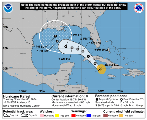
Hurricane Rafael has continued to slightly strengthen as it passes over the Cayman Islands. From now until it makes landfall in Cuba, rapid intensification is expected to occur.
Here are the current stats from the NHC:
SUMMARY OF 1000 PM EST…0300 UTC…INFORMATION
———————————————–
LOCATION…19.7N 80.4W
ABOUT 60 MI…95 KM ENE OF GRAND CAYMAN
ABOUT 275 MI…440 KM SSE OF HAVANA CUBA
MAXIMUM SUSTAINED WINDS…80 MPH…130 KM/H
PRESENT MOVEMENT…NW OR 320 DEGREES AT 13 MPH…20 KM/H
MINIMUM CENTRAL PRESSURE…985 MB…29.09 INCHES
WATCHES AND WARNINGS
A Hurricane Warning is in effect for…
* Cayman Islands
* Cuban provinces of Pinar del Rio, Artemisa, La Habana, Mayabeque,
Matanzas, and the Isle of Youth
A Tropical Storm Warning is in effect for…
* Cuban provinces of Villa Clara, Cienfuegos, Sancti Spiritus,
and Ciego de Avila
* Lower and Middle Florida Keys from Key West to west of the
Channel 5 Bridge
* Dry Tortugas
A Tropical Storm Watch is in effect for…
* Cuban provinces of Camaguey and Las Tunas
Rafael is becoming a well organized system, despite it being so late in the hurricane season. There is an abundance of convection occurring with this hurricane, and winds have been measured at 80 mph.
Rafael is set to landfall in Cuba tomorrow afternoon, then proceed into the Gulf of Mexico. Models are becoming more aligned, showing the storm taking a westward track towards the Texas Gulf Coast. However there is expected to be a lot of weakening once Rafael reaches the Gulf, meaning the system is likely to be only of tropical storm strength once it interacts with the US Coast.
Tropical Storm conditions are expected to occur in the Florida Keys by tomorrow evening. There will also be an abundance of rainfall in the southeast US this weekend as a result of this system.
We will continue to update as we learn new information.
Category: ALL POSTS, Social Media, Tropical


