Rafael Strengthens, Eyes Northern Gulf Coast Later This Week
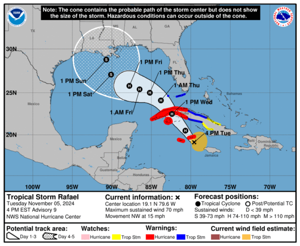
Tropical Storm Rafael is on the brink of hurricane strength as it heads toward the Cayman Islands, with maximum sustained winds currently reaching 70 mph and a minimum central pressure of 989 mb. The storm is moving northwest at 15 mph, positioned about 105 miles east of Grand Cayman and 120 miles west-northwest of Montego Bay, Jamaica. A Hurricane Warning is in effect for the Cayman Islands and several Cuban provinces, including Pinar del Rio, Artemisa, La Habana, Mayabeque, Matanzas, and the Isle of Youth, indicating that hurricane conditions are expected within the warning areas within 36 hours. Tropical Storm Warnings cover additional Cuban provinces, the Dry Tortugas, and the Lower and Middle Florida Keys, while a Tropical Storm Watch extends to other areas of central Cuba.
Rafael’s northwestward movement is being steered by a low- to mid-level ridge over the western Atlantic, which will guide the storm near or over the Cayman Islands tonight before crossing western Cuba on Wednesday. As Rafael enters the Gulf of Mexico late Wednesday, its track becomes less certain, with models suggesting that the storm may either turn westward due to a strengthening ridge along the northern Gulf Coast or possibly veer northward if the ridge weakens. This uncertainty in track guidance underscores the importance of monitoring the system for residents along the Gulf Coast, as even slight deviations could have significant impacts.
Data from an Air Force Hurricane Hunter aircraft indicate that Rafael has developed a more organized inner wind structure and a ragged eye, suggesting that the storm is poised for steady to rapid intensification. Flight-level wind measurements reached 73 kt, indicating robust circulation, especially on the northeast side of the storm’s center. Favorable conditions, such as high sea surface temperatures and low vertical wind shear, are expected to support continued strengthening, and Rafael could reach hurricane status within the next several hours as it passes through the Cayman Islands, with further intensification anticipated before it reaches Cuba.
Once Rafael moves north of 25°N in the Gulf of Mexico, it will encounter increasing vertical wind shear and drier air, which should slow its intensification and likely lead to weakening. Sea surface temperatures will also be slightly cooler in the northern Gulf, contributing to an environment that may cause the system to gradually lose strength. The forecast peak intensity is set near the high end of the guidance envelope, although there is a chance Rafael could become slightly stronger than forecasted, given the favorable conditions in the near term.
In terms of hazards, Rafael is expected to bring hurricane-force winds and dangerous storm surge to the Cayman Islands tonight, along with destructive wave action. The storm surge could raise water levels by 1 to 3 feet above normal tide levels in the Cayman Islands, while the southern coast of Cuba within the Hurricane Warning area could see surges reaching 6 to 9 feet above ground level, particularly in areas of onshore winds. These coastal impacts will be compounded by large waves, posing a significant threat to life and property along vulnerable shorelines.
Heavy rainfall associated with Rafael is another major concern, particularly across Jamaica, the Cayman Islands, and parts of Cuba. Rainfall totals of 3 to 6 inches are expected, with isolated higher amounts up to 10 inches possible in mountainous regions. This intense rainfall raises the potential for flash flooding and mudslides, especially in areas of elevated terrain. In the Florida Keys, rainfall totals of 1 to 3 inches are expected as the storm moves closer, with localized flooding possible in low-lying areas.
Tropical storm conditions are likely to spread into the Lower and Middle Florida Keys by Wednesday and persist into Wednesday night. While it is still too soon to determine Rafael’s exact impacts on the northern Gulf Coast, residents in this region should monitor updates closely, as the storm could bring rain, wind, and coastal flooding depending on its eventual track and intensity in the Gulf.
In summary, Rafael is a rapidly organizing tropical storm with high potential to reach hurricane strength tonight as it impacts the Cayman Islands and Cuba. Favorable atmospheric conditions will allow for intensification in the short term, although challenges await in the northern Gulf where increased shear and cooler waters should lead to a gradual weakening. Nevertheless, Rafael’s impacts are already being felt across the western Caribbean, and the system remains a significant threat to coastal regions and low-lying areas in its path.
Category: Alabama's Weather, ALL POSTS, Social Media, Tropical


