Tropical Storm Rafael Update: System Expected to Approach Cuba on Wednesday
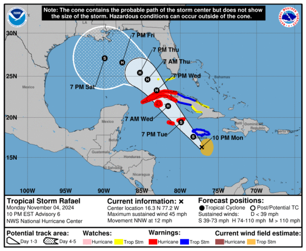
Rafael has not changed much throughout the afternoon; winds have stayed steady around 45 mph. However, this should change overnight and into tomorrow as the storm begins to intensify at a faster rate. Right now, tropical storm force winds extend about 105 miles away from the center of the storm.
Here are the latest details from the NHC:
SUMMARY OF 1000 PM EST…0300 UTC…INFORMATION
———————————————–
LOCATION…16.3N 77.2W
ABOUT 120 MI…195 KM SSW OF KINGSTON JAMAICA
ABOUT 335 MI…540 KM SE OF GRAND CAYMAN
MAXIMUM SUSTAINED WINDS…45 MPH…75 KM/H
PRESENT MOVEMENT…NNW OR 335 DEGREES AT 12 MPH…19 KM/H
MINIMUM CENTRAL PRESSURE…996 MB…29.42 INCHES
SUMMARY OF WATCHES AND WARNINGS IN EFFECT:
A Hurricane Warning is in effect for…
* Cayman Islands
* Cuban provinces of Pinar del Rio, Artemisa, La Habana,
Mayabeque, Matanzas, and the Isle of Youth
A Tropical Storm Warning is in effect for…
* Jamaica
* Cuban provinces of Villa Clara, Cienfuegos, Sancti Spiritus,
and Ciego de Avila
A Tropical Storm Watch is in effect for…
* Cuban provinces of Camaguey and Las Tunas
* Lower and Middle Florida Keys from Key West to west of the
Channel 5 Bridge
* Dry Tortugas
Key Points:
1. Rafael is expected to become a hurricane sometime on Wednesday. Around this time, the storm will approach Cuba where it will likely make landfall as a low end hurricane. After this, Rafael will move into the Gulf of Mexico overnight Wednesday. Its exact path after this point is still uncertain. Most models show the system veering to the west, and reaching the Gulf Coast of the US as a tropical storm.
2. Tropical storm conditions are expected to occur in the Florida Keys late Wednesday night.
3. Heavy rainfall is likely to occur in Florida and other areas of the South as the system moves inland later this week and weekend.
For now, there is still a lot of uncertainty about this system, especially in regards to have it will behave once it reaches the Gulf.
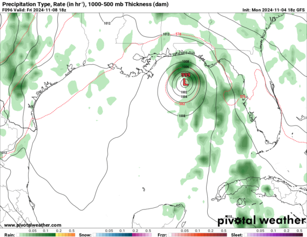
Here is the GFS at 10am CST on Friday:
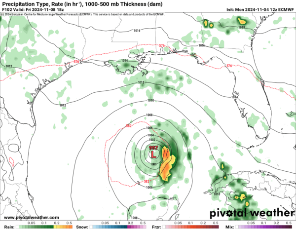
And here is the EURO at 10am CST on Friday:
Obviously, these models are handling the storm quite differently. We will have to wait another day or so before we have more conclusive model data before we can have a better idea of what this storm will do in the Gulf.
Category: ALL POSTS, Social Media, Tropical


