Dry Today; Showers Are Possible Tomorrow Through Mid-Week
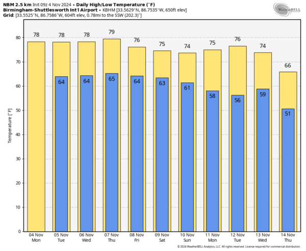
DRY, MILD MONDAY: With a partly sunny we are forecasting a high in the upper 70s for North Alabama today, with low 80s for the southern counties of the state. We note the average high for Birmingham on November 4 is 69.
Moisture will increase in coming days, and we will bring in a chance of scattered showers and thunderstorms tomorrow and each day through Friday as a surface front stalls out just to the northwest. Rain distribution won’t be very even; any one spot will see a 40-50 percent chance of seeing rain each day. Highs will stay in the 77-81 degree range across Alabama.
THE ALABAMA WEEKEND: There is a huge amount of uncertainty due to model differences in handling the tropical system in the Gulf of Mexico. The American GFS model suggests Saturday will be a day with widespread, beneficial rain, while the European global model shows little rain at all as it keeps the tropical system far to the southwest. We will have much better clarity over the next 36-48 hours; for now we will mention a chance of rain Saturday, with a trend toward drier weather Sunday. Highs over the weekend will be in the 70s. See the video briefing for maps, graphics, and more details.
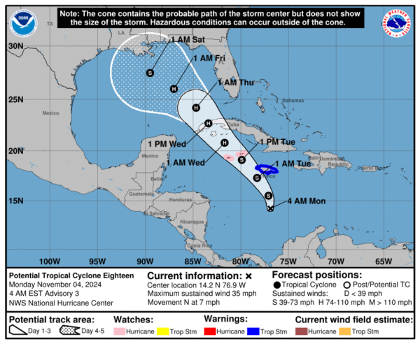
TROPICS: Potential Tropical Cyclone 18 is in the Caribbean, about 260 miles south of Kingston, Jamaica. Winds are 35 mph, and the system is expected to become Tropical Storm Rafael over the next 24 hours.
The latest NHC forecast track brings it over the western tip of Cuba as a category one hurricane Wednesday, and into the southern Gulf of Mexico Thursday. From there, weakening is likely due to cooler sea surface temperatures and stronger winds aloft, producing shear. It is too early to know if Alabama will see beneficial rain; it is just one possibility. We will have much better clarity in coming days once the system becomes organized and we get dropsonde data from hurricane hunters.
ON THIS DATE IN 1935: Called the Yankee Hurricane, this Category 2 storm affected the Bahamas and South Florida. The storm remains the only tropical cyclone to hit Miami from the Northeast in November.
ON THIS DATE IN 1985: Heavy rains from the remnants of tropical storm Juan dropped 10 to 19 inches of rain on West Virginia and surrounding states, causing 62 deaths. A maximum rainfall amount of 19.77 inches was recorded near Montebello in the Blue Ridge Mountains in Virginia. The flood in West Virginia was considered the worst in the state’s history.
Look for the next video briefing here by 3:00 this afternoon… enjoy the day!
Category: Alabama's Weather, ALL POSTS, Weather Xtreme Videos


