Potential Tropical Cyclone 18 Has Been Designated
POTENTIAL TROPICAL CYCLONE 18 – EVENTUAL RAFAEL
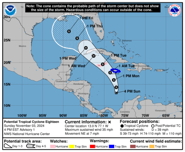
PTC 18, what was Invest 97-L, currently located over the south-central Caribbean, south of Jamaica, is showing signs of increased organization. Enhanced shower and thunderstorm activity is beginning to wrap around the low-pressure center, indicating a high likelihood that this system will develop into a tropical depression by Monday and possibly become a tropical storm soon after. This system is expected to move north and northwest, bringing tropical storm conditions to Jamaica by Monday night and the Cayman Islands by Tuesday. Residents in these areas should prepare for squalls with heavy rain, potential flooding, and gusty winds.
WATCHES AND WARNINGS
The government of the Cayman Islands has issued a Hurricane Watch
for Grand Cayman, Little Cayman and Cayman Brac.
The government of Jamaica has issued a Tropical Storm Warning for
the island of Jamaica.
HURRICANE HUNTERS
The Hurricane Hunters are on their way back to Keesler AFB. Another mission is scheduled to depart before midnight and will be on station during the early morning hours.
As Invest 97-L advances, it is forecasted to cross western Cuba late Tuesday night into Wednesday morning, entering the southeastern Gulf of Mexico as a tropical storm. Environmental conditions in the Gulf vary significantly, with favorable strengthening conditions in the southern Gulf and highly unfavorable conditions in the northern Gulf. This discrepancy introduces uncertainty regarding the storm’s potential strength as it moves toward the Gulf Coast.
Two main scenarios could unfold for Invest 97-L once it reaches the Gulf. In the first, a fast-moving system could approach the Florida Panhandle and Big Bend area by late this week. However, strong wind shear over the northern Gulf would likely cause significant weakening before it reaches these areas. The second scenario involves a slower-moving system that remains in the central Gulf, encountering strong wind shear that would hinder further development and potentially lead to its dissipation before making landfall.
Given these possibilities, there is still considerable uncertainty about the ultimate track and strength of Invest 97-L. All residents and interests across the Gulf of Mexico, particularly along the northern and eastern Gulf Coasts, should remain vigilant and monitor updates closely as the system progresses this week.
Rafael could enhance rainfall across Alabama by Friday and Saturday, which would be great news given that winds should diminish substantially as the storm approaches the coast. It will be breezy across the state late in the week though. Tomorrow night’s breeziness into Tuesday will not be related to the system.
POTENTIAL SARA
In addition to Invest 97-L, a separate area of disturbed weather is anticipated to form near the northern Leeward Islands by the middle of the week. This system is expected to move westward, guided by the same high-pressure ridge influencing Invest 97-L. By late this week, this disturbance could reach the southern Bahamas and may continue on a path toward the northwestern Caribbean by next weekend, potentially impacting areas near western Cuba and the Yucatan Peninsula. The GFS shows is as a hurricane moving through the Florida Straits between the Keys and Cuba next Sunday.
This emerging system, while still in its formative stage, highlights the need for those in the northern Caribbean and Bahamas to monitor developments closely, as it could pose a new threat heading into late this week and next weekend.
THE LATEST ON PATTY
Subtropical Storm Patty, currently located about 280 miles east-southeast of Lajes Air Base in the Azores, maintains maximum sustained winds of 45 mph despite facing strong vertical wind shear and cooler sea surface temperatures. While thunderstorms have recently redeveloped near its center, Patty is expected to weaken due to unfavorable conditions and become a post-tropical cyclone by early Monday as it moves eastward toward Europe.
Category: ALL POSTS, Social Media, Tropical


