Warm Sunday Across Alabama; Hurricane Hunters Investigating 97-L, Could be a PTC This Afternoon
A few notes early on this Sunday afternoon…
…It was a beautiful morning in most areas across Alabama as folks got an extra hour of rest overnight. Lows were in the 60s mainly with a few 50s in the colder spots. Spots hung tough in the east, but nmost locations were clear to partly cloudy at worst.
…Temperatures are warming nicely under a still strong fall sun and are in the 80s in most locations, outperforming our temperature forecast in many cases. East Alabama was the exception with the heavier stratus deck. A dense cumulus field was forming in most locations where it has been sunny all morning. Convection…you gotta love it!
…The week starts with mostly sunny and warm conditions, but clouds will increase later in the day. Following that, expect partial clearing with a breezy atmosphere and slightly cooler temperatures. A mix of sun and clouds will prevail, with breezy conditions and the possibility of showers developing late in the day. Temperatures will range from lows in the low 60s to highs in the upper 70s to low 80s.
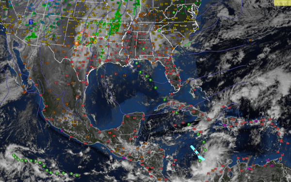
…Air Force Hurricane Hunters are investigating the system in the western Caribbean south of Jamaica. The system is in the process of organizing. It has a mid level circulation but low level circulation may not be present yet. The NHC could initiate advisories on a Potential Tropical Cyclone with this system this afternoon.
…We will be watching the Caribbean and Gulf as Invest 97L becomes a tropical depression over the next 36 hours and a tropical storm and hurricane by Tuesday before crossing Cuba into the Gulf. The system is expected to weaken as it moves into the Central Gulf and should fall mostly apart before reaching the Central Gulf Coast late in the week and early into the weekend. But the hurricane models do have it becoming very strong over the western Caribbean and southeastern Gulf. We will have to watch it for sure.
…Midweek brings a pattern shift with partly to mostly cloudy skies and scattered showers, particularly in the northwest and southeast areas as we are sandwiched between a front to the northwest and the tropical system to the southeast. Warm and humid weather will continue, accompanied by breezy winds. The following day will remain mostly cloudy with periodic showers and stronger breezes. Toward the end of the week, conditions will be marked by cloudy skies, breezy winds, and significant rainfall throughout the day.
…The weekend will start with more rain and potential thunderstorms and the convergence from the dissipating low combines with the front, maintaining the breezy conditions. By the end of the weekend, skies will clear, bringing sunny weather and cooler temperatures. Winds will shift to the northwest, providing a refreshing change to close out the week.
…A severe thunderstorm watch was just issued for the Red River Valley of North Texas and southern Oklahoma.
Category: Alabama's Weather, ALL POSTS, Social Media, Tropical


