
Midday Nowcast: Morning Clouds Give Way to Afternoon Sun; Staying Mostly Dry
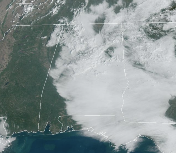
FINAL DAYS OF OCTOBER: Despite a few showers for some lucky folks yesterday, the pattern remains dry for most of the state the rest of the week. The morning clouds will give way to a sunny afternoon for Alabama and we expect generally sunny day with highs ranging from the upper 70s to lower 80s the rest of this week. Nights will be mostly clear, with lows ranging from the upper 50s to lower 60s. A cold front could bring some showers to northern portions of the state Thursday night and Friday, but again, it looks like most places will remain dry.
BIRMINGHAM ALMANAC: For October 28th, the average high for Birmingham is 71° and the average low is 49°. The record high is 86° set in 2016, while the record low is 27° set in 1957. We average 0.11” of precipitation on this date, and the record value is 2.03” set in 1935.
ACROSS THE USA: A strong Pacific system will track across the Intermountain West early this week. Strong winds and higher elevation snow will affect the Western States. Further east, strong southerly winds will usher in record warmth for most of the central and eastern United States. The threat for rapid spread of wildfires today then increasing chance for severe thunderstorms for the center of the nation.
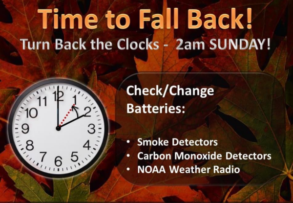
ROLLING INTO NOVEMBER: For now, the weekend looks dry with warm afternoons and pleasant nights; highs will stay around 80 degrees, with lows not too far from 60°. Not much change in the forecast for next week, but at some point the pattern will change and we will start to bring higher rain chances back into the forecast. Also, this weekend Daylight Saving Time ends and we fall back onto Standard Time meaning we turn the clocks back one hour. This is a good reminder to also check and change your batteries in smoke, carbon monoxide detectors, and your NOAA Weather Radios.
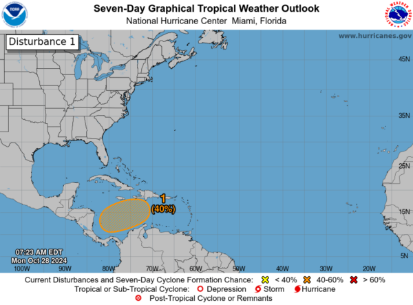
IN THE TROPICS: In the Southwestern Caribbean Sea, a broad area of low pressure is likely to develop over the southwestern Caribbean Sea in a few days. Gradual development is possible thereafter, and a tropical depression could form late this week or over the weekend while the system begins to drift northward or northeastward over the southwestern and central Caribbean Sea. Formation chance through 7 days…medium…40 percent. Next name up is Patty.
WORLD TEMPERATURE EXTREMES: Over the last 24 hours, the highest observation outside the U.S. was 112.8F at Ventersdorp, South Africa. The lowest observation was -75.3F at Dome A, Antarctica.
CONTIGUOUS TEMPERATURE EXTREMES: Over the last 24 hours, the highest observation was 100F at Coolidge, AZ. The lowest observation was 5F at Mount Washington, NH.
Category: Alabama's Weather, ALL POSTS, Social Media
About the Author (Author Profile)
Macon, Georgia Television Chief Meteorologist, Birmingham native, and long time Contributor on AlabamaWX. Stormchaser. I did not choose Weather, it chose Me. College Football Fanatic. @Ryan_StinnetSubscribe
If you enjoyed this article, subscribe to receive more just like it.


