
Midday Nowcast: Severe Clear and Staying Dry
DRY WEATHER CONTINUES: No signs of rain the next 7-10 days for Alabama, and it is looking more and more likely that it will be into November before we can bring rain back to the forecast. Sure looks like Birmingham will have the first October with no rain since 1924. This week will continue to feature sunny, gorgeous days with highs in the low to mid 80s, which are about ten degrees above average. Lows will moderate as well, climbing into the 50s later this week, but still feeling amazing in the evenings, nights, and morning hours.
BIRMINGHAM ALMANAC: For October 21st, the average high for Birmingham is 74° and the average low is 52°. The record high is 89° set in 1963, while the record low is 30° set in 1913. We average 0.11” of precipitation on this date, and the record value is 3.08” set in 1959.
ACROSS THE USA: A few severe thunderstorms and localized heavy rainfall will affect portions of the Plains through Monday. Meanwhile, a strong Pacific system is expected to move ashore with strong winds and accumulating snow for the highest terrain. For Alaska, an early season winter storm to bring dangerous seas, strong winds and heavy snow through early this week. The United States east coast remains tranquil.
WEEKEND WEATHER: A dry cold front will pass through the state early in the weekend, and will bring cooler air back into the Deep South by Sunday. Temperatures reach the low 80s Saturday, but the high Sunday will be in the 70s, with those overnight lows likely falling back into the 40s. The quiet weather pattern will persist into the final week of October.
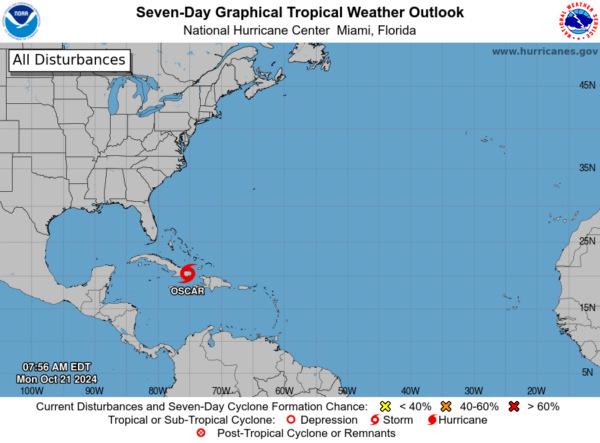
IN THE TROPICS: Nadine dissipated over southern Mexico this weekend. Oscar remains a tropical storm over eastern Cuba and is forecast to make a turn to the northwest and north later today, followed by a faster northeastward motion on Tuesday and Wednesday. On the forecast track, the center of Oscar is expected to continue moving across eastern Cuba through this afternoon, then emerge off the northern coast of Cuba late today or tonight and move near the southeastern and central Bahamas on Tuesday. Some additional weakening could occur while Oscar moves across the mountainous terrain of eastern Cuba. This system is no threat to the U.S.
The rest of the Atlantic is quiet and no tropical development is expected the next 7-10 days. The next name up if anything develops between now and the end of November would be Patty.
WORLD TEMPERATURE EXTREMES: Over the last 24 hours, the highest observation outside the U.S. was 108.3F at Mina, Saudi Arabia. The lowest observation was -85.4F at Vostok, Antarctica.
CONTIGUOUS TEMPERATURE EXTREMES: Over the last 24 hours, the highest observation was 95F at Rio Grande Village, TX. The lowest observation was 21F at Wolf Creek Pass and Berthoud Pass, CO.
Category: Alabama's Weather, ALL POSTS, Social Media
About the Author (Author Profile)
Macon, Georgia Television Chief Meteorologist, Birmingham native, and long time Contributor on AlabamaWX. Stormchaser. I did not choose Weather, it chose Me. College Football Fanatic. @Ryan_StinnetSubscribe
If you enjoyed this article, subscribe to receive more just like it.


