PTC 15 Has Formed…Will become Tropical Storm Nadine Before Moving Inland Tomorrow
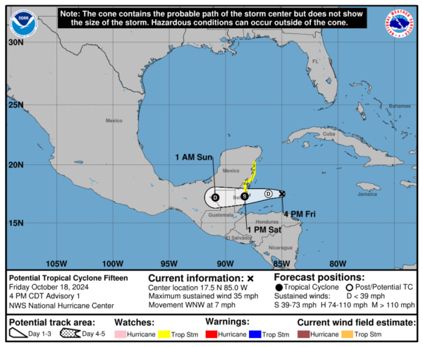
Potential Tropical Cyclone Fifteen has formed in the northwestern Caribbean Sea and is expected to bring heavy rainfall, coastal flooding, and tropical storm conditions to portions of Belize and Mexico’s Yucatan Peninsula. Currently centered about 210 miles east of Belize City, the system is moving west-northwest at about 7 mph, with maximum sustained winds near 35 mph. Though it hasn’t yet become a tropical cyclone, the system is forecast to strengthen slightly before making landfall tomorrow, potentially becoming Tropical Storm Nadine by that time. Tropical Storm Watches have been issued for Belize City northward to Tulum, Mexico.
The system is forecast to bring widespread rainfall of 4-8 inches across northern Belize, northern Guatemala, and southern Mexico, with isolated areas receiving more than 12 inches. These heavy rains could result in localized flash flooding, especially in low-lying areas. Coastal areas near and to the north of the storm’s path could also experience minor flooding due to onshore flow. While tropical storm conditions are expected in the watch areas, they are likely to be short-lived, with the storm weakening and dissipating over land by late Sunday.
Despite favorable environmental conditions like warm sea-surface temperatures and low wind shear, the system has a limited window for significant intensification before moving inland. The National Hurricane Center forecasts it to become a low-end tropical storm, potentially named Nadine, before landfall, but it is expected to weaken rapidly as it tracks inland across the Yucatan Peninsula and northern Guatemala. Given its current track, the main hazards are likely to be heavy rainfall and flash flooding, rather than strong winds or storm surge.
The system is no threat to the United States.
Category: ALL POSTS, Social Media, Tropical


