Midday Nowcast: Gradual Warming Trend; The Long Dry Spell Continues
FANTASTIC FALL FRIDAY: After another frosty morning across Alabama, we are seeing sunshine in full supply today, allowing temperatures to surge into the 70s this afternoon. Hard to find a fault with the weather across Alabama and much of the Deep South today.
FRIDAY NIGHT LIGHTS: Perfect weather for high school football games across Alabama tonight. A clear sky with temperatures in the mid 60s at kickoff, falling into the 50s during the second half.
BIRMINGHAM ALMANAC: For October 18th, the average high for Birmingham is 75° and the average low is 53°. The record high is 89° set in 2016, while the record low is 31° set in 1948. We average 0.11” of precipitation on this date, and the record value is 1.95” set in 1937.
ACROSS THE USA: Tranquil and near seasonable weather pattern for most of the eastern U.S. expected this weekend. Along the coastline, continuous onshore flow may bring risk of rip currents and coastal flooding. For the west, a strong cold front will increase winds and fire weather concerns, along with heavy mountain snows. Rainfall for lower elevations could lead to flash flooding for the southern High Plains.
WEEKEND WEATHER AND NEXT WEEK: Dry weather continues; expect sunshine in full supply tomorrow and Sunday with highs in the 70s. And, the long dry spell continues through next week and temperatures moderate some with highs closer to 80 degrees. Statistically, October is the driest month of the year for Alabama and much of the Deep South, so little to no rain in Alabama this time of year is completely normal. Overall, phenomenal fall weather for Alabama, and it may be November before we can bring rain back to the forecast.
FOOTBALL WEATHER: Tomorrow Auburn plays Missouri in Columbia (11:00a CT kickoff)… the sky will be sunny with temperatures rising from near 68 at kickoff into the low 70s during the second half.
Alabama will be in Knoxville to take on Tennessee (2:30p CT kickoff)… it will be a sunny day. About 70 degrees at kickoff, falling into the 60s by the fourth quarter.
And, UAB will be in Tampa to play South Florida (2:30p CT kickoff)… the weather will be sunny and warm with temperatures in the low to mid 80s.
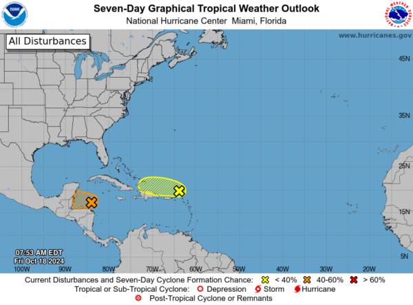
IN THE TROPICS: In the Central Tropical Atlantic, Invest 94L: A trough of low pressure is producing disorganized showers and thunderstorms extending a couple hundred miles north of Puerto Rico and the Virgin Islands. Development, if any, of this disturbance should be slow to occur while it moves quickly westward to west-northwestward at around 20 mph, continuing north of Puerto Rico and the Virgin Islands today, then near Hispaniola and the southeastern Bahamas this weekend. Further development is not expected due to strong upper-level winds by early next week. Formation chance through 7 days…low…10 percent.
And, Invest 95L: Widespread showers and thunderstorms continue across the northwestern Caribbean Sea in association with a broad area of low pressure that is gradually becoming better defined to the north of eastern Honduras. Environmental conditions appear conducive for some additional development over the next day or so, and a short-lived tropical depression or storm could form before the system moves inland over Belize and the Yucatan Peninsula of Mexico on Saturday. Regardless of development, locally heavy rainfall is likely across portions of Central America and southern Mexico through the weekend. Formation chance through 48 hours…medium…50 percent.
The next name up is Nadine. The rest of the Atlantic is quiet and we may be seeing the Atlantic hurricane season wind down…I hope so anyways.
WORLD TEMPERATURE EXTREMES: Over the last 24 hours, the highest observation outside the U.S. was 109.4F at Mina, Saudi Arabia. The lowest observation was -78.9F at Dome A, Antarctica.
CONTIGUOUS TEMPERATURE EXTREMES: Over the last 24 hours, the highest observation was 95F at Tecopa, CA. The lowest observation was 12F at Kirk, OR.
Category: Alabama's Weather, ALL POSTS, Social Media


