Beautiful But Very Warm This Afternoon
Sunshine is dominating the skies across nearly all of North and Central Alabama this afternoon, except for the northeast corner of the area where a few cirrus clouds are floating overhead. Looking at the latest model trends for tonight, we can almost forget about the very small chance of sprinkles or very light rain that were possible for the northern part of the area. Only the extreme northeast corner of the area, mainly Jackson and DeKalb counties, will have a very small chance for precipitation. A few more clouds may float into the area late, but skies should stay mostly clear. Temperatures as of 2pm were in the 80s, with the warm spot being Demopolis at 87. Alexander City was the cool spot at 81. Birmingham was at 84. Tonight’s lows will be in the mid 50s to the lower 60s. It may be over a week before we see low temperatures this warm again.
A cold front will work through the area tonight through tomorrow morning that will usher in a reinforcing shot of dry air, but it will also begin a big cooling trend for North/Central Alabama. Highs will top out in the upper 60s to the mid 80s on Monday, but highs will be in the 60s and 70s on Tuesday, in the 60s on Wednesday and Thursday, and starting a small warming trend on Friday with highs in the upper 60s to the mid 70s. And if you like cold weather, early morning lows on Wednesday, Thursday, and Friday will be in the 30s to the 40s. Frost advisories may be possible on one or two of those mornings.
Next weekend will be absolutely beautiful, and I will say, darn near perfect (for me, anyway). Sunny skies will be the name of the game with mild afternoon temperatures in the 70s on both days.
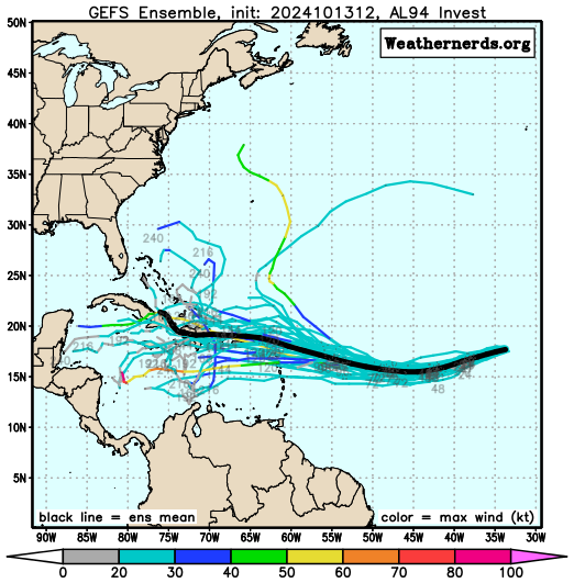
A well-defined area of low pressure, named Invest 94L, located several hundred miles west of the Cabo Verde Islands, continues to have limited shower and thunderstorm activity. Currently, the system is in an unfavorable environment, and development isn’t expected in the next couple of days. However, as it moves westward to west-southwestward, conditions may improve by mid to late this week. There is a chance a tropical depression could form as it shifts west-northwestward, possibly nearing the Leeward Islands by the end of the week. The formation chance is 10% over the next 48 hours and 40% over the next seven days. The rest of the tropics are surprisingly quiet at this point.
Category: Alabama's Weather, ALL POSTS, Social Media, Tropical
About the Author (Author Profile)
Scott Martin is an operational meteorologist, professional graphic artist, musician, husband, and father. Not only is Scott a member of the National Weather Association, but he is also the Central Alabama Chapter of the NWA president. Scott is also the co-founder of Racecast Weather, which provides forecasts for many racing series across the USA. He also supplies forecasts for the BassMaster Elite Series events including the BassMaster Classic.Subscribe
If you enjoyed this article, subscribe to receive more just like it.


