Almost Summer-Like Weather Today; The Big Cooldown Starts Tomorrow
STILL IN A LONG STRETCH OF DRY WEATHER
Summer will try to make its last stand today, as a cold front approaching the area will pull some warmer and slightly more humid air up from the south. Temperatures will be hot for mid-October, reaching the mid to upper 80s. Skies will be sunny for the most part, but some clouds may invade late. The front will eventually push into the area tonight and into the overnight hours, and a few sprinkles may be possible over the Tennessee Valley region of North Alabama and the extreme northern parts of Central Alabama.
A BIG COOL DOWN HEADING OUR WAY
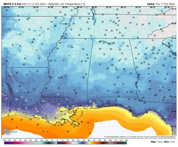
The cold front moves through early Monday, possibly bringing a few sprinkles before sunrise. Once it passes, expect cooler, drier air with highs ranging from the upper 60s in the north to the lower 80s in the south. By Tuesday, fall will settle in. Ridging to our west brings a northwesterly flow across Alabama. Highs will only reach the mid-60s to mid 70s, and we might see frost advisories Wednesday morning with lows in the upper 30s to mid-40s. Sunny skies return midweek, with highs in the 60s. Thursday looks similar, starting with lows in the mid 30s to the lower 40s, but warming to the mid 60s to the low 70s during the afternoon. Friday wraps up the week with sunshine and slightly warmer temps, with highs in the upper 60s to the mid 70s.
NEXT WEEKEND
The only change we can expect is that the weather remains the same for Saturday. Skies remain sunny and we remain dry. Highs in the 70s. Sunday will also be sunny with highs in the mid 70s to the lower 80s.
THE TROPICS
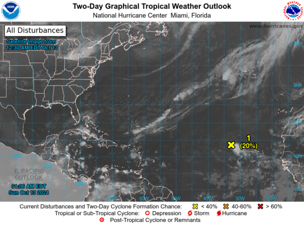
Showers and thunderstorms associated with a low-pressure system a few hundred miles west of the Cabo Verde Islands have shown some increase. However, the system is entering an environment less favorable for development, so its chances of becoming a tropical cyclone are decreasing over the next few days. It is expected to move westward or west-southwestward across the tropical Atlantic, with a potential increase in development chances by the middle of next week when it reaches the western tropical Atlantic. Formation chances remain low at 20% over the next 48 hours and the next seven days.
The rest of the tropics are quiet for now, thank goodness!
SEVERE WEATHER SAFETY
Weather can be unpredictable, often catching us off guard with sudden changes. From thunderstorms and tornadoes to flash floods, being prepared can truly save lives. Alabama’s varied climate brings its share of severe weather, making it crucial for everyone to have a solid safety plan in place. For valuable tips on staying safe when severe weather threatens, check out our Severe Weather Safety Guide. Stay ready, stay safe!
BEACH FORECAST
Visit our Beach Forecast Center to get the latest weather and rip current forecasts for beaches from Fort Morgan to Panama City. This page allows you to select forecasts tailored to your destination, ensuring you have the most accurate and relevant information for your beach plans. Stay informed and safe on your coastal getaway!
ADVERTISE ON THE BLOG
Don’t miss this opportunity! Let us create a customized package tailored to the unique needs of your organization. Our solutions are creative, flexible, and competitively priced. For more information or inquiries, please contact Bill Murray at (205) 687-0782.
E-FORECAST SIGN UP
Get the Alabama Weather Blog’s comprehensive Seven-Day Forecast delivered straight to your inbox twice daily. Known as the most detailed forecast available in Central Alabama, our service ensures you’re always informed and prepared. Subscribe now and gain access to this valuable resource for free!
Category: Alabama's Weather, ALL POSTS, Social Media, Tropical, Weather Xtreme Videos


