Midday Nowcast: Fantastic Fall Weather; Milton Pulling Away from Florida

BEAUTIFUL FALL DAY: Loving these sunny days and fair cool nights this week. Highs remain in the upper 70s and low 80s, while lows in the 50s are quite refreshing. Some colder pockets could reach the 40s early tomorrow morning. This is a very dry air mass, meaning no humidity, and no rain as a long dry spell continues for Alabama.
BIRMINGHAM ALMANAC: For October 10th, the average high for Birmingham is 78° and the average low is 57°. The record high is 90° set in 2010, while the record low is 36° set in 2000. We average 0.09” of precipitation on this date, and the record value is 2.37” set in 1999.
WEEKEND AND BEYOND: The pattern doesn’t change as we roll into the weekend and next week. It is a dry forecast for the Deep South with sunny pleasant days and clear cool nights. Highs will be mostly in the upper 70s and low 80s, with lows in the 50s over the northern and central counties. Even cooler air arrives next week; highs drop into the 60s with lows in the 40s over the northern 2/3 of the state by Tuesday and Wednesday. And, still no sign of any meaningful rain for Alabama for at least the next 7-10 days.
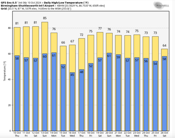
FOOTBALL WEATHER: Expect a clear sky for the high school games across Alabama tomorrow night with temperatures falling from the low 70s at kickoff, into the 60s during the second half.
Saturday, Alabama hosts South Carolina (11:00a CT kickoff) at Bryant-Denny Stadium… the sky will be sunny with temperatures rising from near 77 at kickoff, into the low 80s by the final whistle.
UAB is on the road; they play Army in West Point NY (11:00a CT kickoff)… the weather will be dry. With a sunny sky, temperatures rise from 68 degrees at kickoff into the low 70s by the fourth quarter.
HURRICANE MILTON: Milton made landfall at Siesta Key in Sarasota County last night at 8:30PM EDT. It then crossed the state, producing widespread flooding and wind damage. Unfortunately, at least four deaths have been reported so far with this storm. The system is now offshore, and is increasing in forward speed as it moves away from the United State.

Latest update from the NHC has the center of Hurricane Milton located near latitude 29.1 North, longitude 78.5 West. Milton is moving toward the east-northeast near 20 mph. A turn toward the east is expected later today, with that motion forecast to continue over the western Atlantic for the next few days. On the forecast track, the center of Milton will continue to move away from the east coast of Florida and pass north of the northwestern Bahamas today.
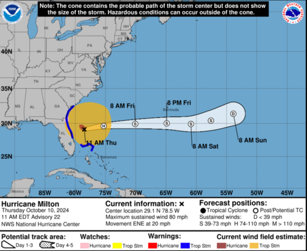
Maximum sustained winds are near 80 mph with higher gusts. Milton is forecast to become a powerful post-tropical storm this afternoon or evening, with gradual weakening expected during the next several days. Hurricane-force winds extend outward up to 70 miles from the center and tropical-storm-force winds extend outward up to 310 miles. The estimated minimum central pressure is 983 mb (29.03 inches).
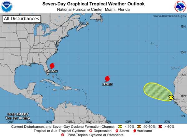
REST OF THE TROPICS: Leslie remains a minimal hurricane with winds of 80 mph and will remain a fish storm. The other area the NHC is monitoring, is about to emerge off the African Coast, and has a low chance of development the next seven days.
WORLD TEMPERATURE EXTREMES: Over the last 24 hours, the highest observation outside the U.S. was 109.2F at Ejido Nuevo Lean, Mexico. The lowest observation was -83.6F at Dome A, Antarctica.
CONTIGUOUS TEMPERATURE EXTREMES: Over the last 24 hours, the highest observation was 109F at Ogilby, CA. The lowest observation was 18F at Davis, WV.
Category: Alabama's Weather, ALL POSTS, Social Media
About the Author (Author Profile)
Macon, Georgia Television Chief Meteorologist, Birmingham native, and long time Contributor on AlabamaWX. Stormchaser. I did not choose Weather, it chose Me. College Football Fanatic. @Ryan_StinnetSubscribe
If you enjoyed this article, subscribe to receive more just like it.


