
Morning Look at the Tropics: Milton Leaving the State of Florida. A Recap of the Storm and a Look at Where it is Headed.
Good morning! We want to thank everyone who followed our reports on Milton. We took a break after landfall to get some sleep. This morning, I want to review a few things about Milton and where it is now. Also, will look at the rest of the tropics.
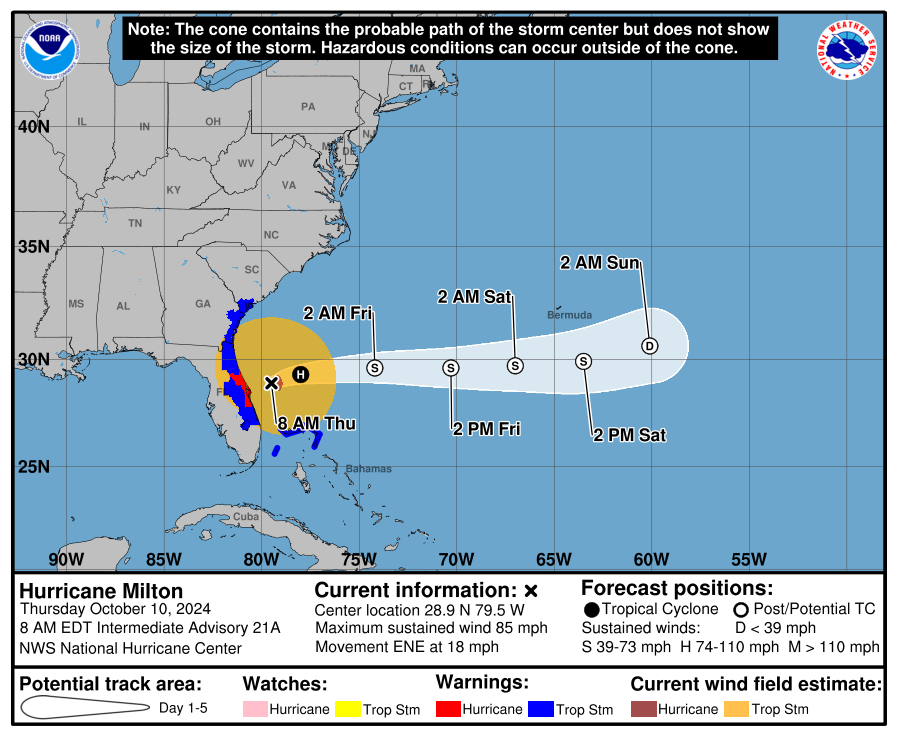
The NHC produced their latest advisory as of 7am CDT. The center of Milton is pulling away from the east coast of Florida. It is moving to the ENE at 18 mph with max winds at the center at 85 mph, so Milton is still a hurricane. Pressure is at 980mb.
Through the night, Hurricane Milton has decreased in intensity but still caused problems with rain, winds and surge as it made its way quickly across the state of Florida through the overnight hours.
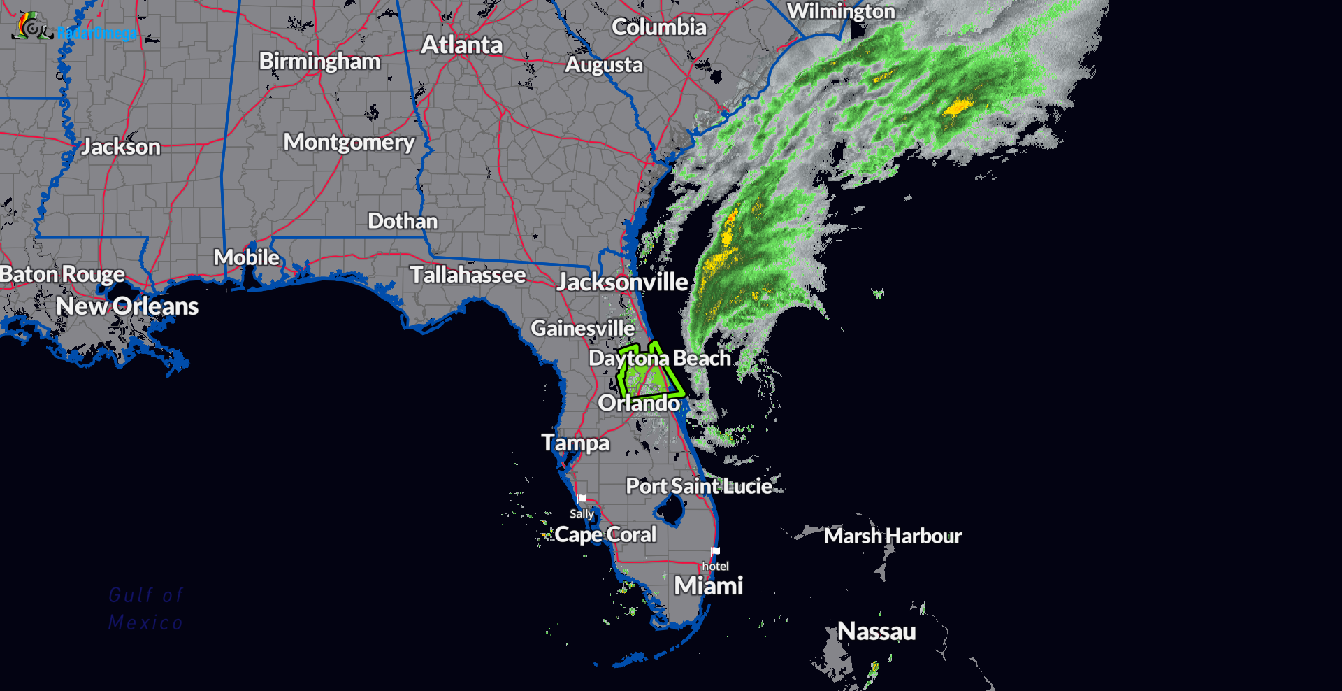
Looking at radar, Milton is a shell of what it once was. Most of the rain is off shore. Still some strong winds and surge concerns this morning for parts of the east coast of Florida and SE Georgia.
Sebastian Inlet, FL to Altamaha Sound, GA…3-5 ft
St. Johns River…2-4 ft
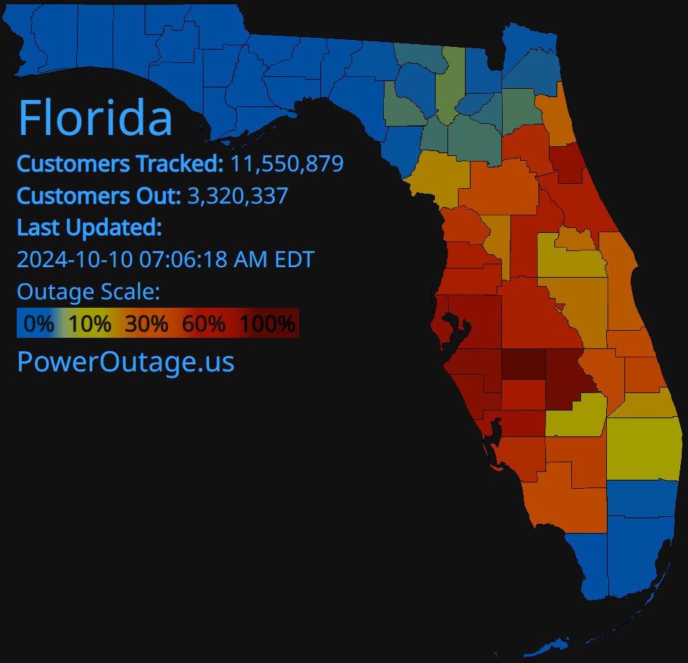
The latest power outages for the state as of 7am eastern time is over 3.3 million.
Milton will continue to move ENE today and then more easterly tonight, passing north of the Bahamas. It is expected to weaken in dissipate in about 4 days.
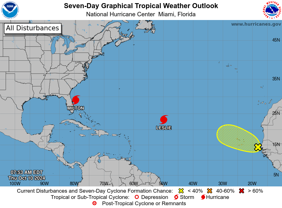
Elsewhere in the tropics, we still have Hurricane Leslie which will not have an impact on land and will gradually dissipate. A new disturbance has moved off Africa. It is expected to run into an environment that should not promote much development.
Recap of a few of the standout impacts from Milton:
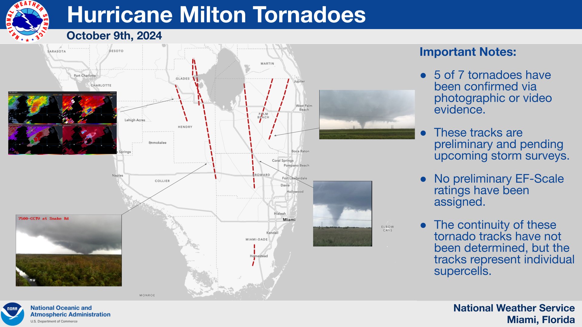
Tornadoes: Conditions ahead of Milton set the stage for a historic tornado outbreak. At latest count, 126 tornado warnings were issued by the state of Florida on Wednesday, the most in one day for the state. Kudos to the Storm Prediction Center for their outlook early in the day showing the enhanced conditions for the potential of strong tornadoes. These were very visible, wedge-look tornadoes that has caused tremendous damage and tragically loss of life.
#Hurricane #Milton produced 35+ preliminary #tornado reports and 126 #tornado warnings. Here are your Top 5 most-prolific tornado-producing tropical cyclones. #Beryl already cracked the Top 5 earlier this year.
Hurricane Ivan 2004 (118 tornadoes)
Hurricane Beulah 1967 (115… pic.twitter.com/knI29bvm5q— Kathryn Prociv (@KathrynProciv) October 10, 2024
Graphic from NWS Miami on the tornado tracks:
Heavy Rain: Record amounts of rain fell especially across the Tampa Bay area. There was a large area of at least 10 inches of rain in a 24 hour period. Per Greg Carbin, it has been awhile since we have seen that much rain in a short amount of time in Florida.
Estimated hourly accumulating #Milton rainfall for 24 hours ending at 6 am EDT, Oct. 10, 2024. That’s a rather large area with at least 10-inches of estimated rainfall over 24 hours! May be a new entry into the Top 10 Prolific Rainfall days since 2005 but more analysis needed. pic.twitter.com/72s3lpaMa1
— Greg Carbin ?? (@GCarbin) October 10, 2024
Okay, this is a wild stat.
Tampa received 11.23″ of rainfall on Wednesday from #Milton. Their previous wettest October 1-31st was 10.33″ in 1922.
THEY BROKE THE MONTHLY RECORD IN A SINGLE DAY. pic.twitter.com/jdW3HpRihV
— Heather Zons (@HeatherZWeather) October 10, 2024
Damaging winds: There will be full assessment of the damage across the state. A couple of the big stories that emerged came out of Tampa Bay with a crane that collapsed into the Tampa Bay Times Building and destruction of the roof of Tropicana Field.
This is the construction crane that collapsed and fell into the Tampa Bay Times building. The damage to the building is catastrophic collapsing multiply floors. The water lines broke flooding the building. #flwx #HurricaneMilton #SaintPetersburg pic.twitter.com/4gyh8HQtsF
— Jeff Piotrowski (@Jeff_Piotrowski) October 10, 2024
#TropicanaField roof ripped off by #HurricaneMilton in Tampa St. Pete #RaysBaseball #RaysUp #Tropicanastadium #MLB @jpetramala pic.twitter.com/IfIWYm5hNq
— WxChasing- Brandon Clement (@bclemms) October 10, 2024
Surge: Tremendous surge moved in from Siesta Key (the landfall point) down the coast to Ft Myers.
Multiple feet of storm surge are now inundating downtown Punta Gorda, FL. This is a look at Taylor St in downtown. Water is coming up extremely fast still. #HurricaneMilton pic.twitter.com/nx3KCZBF3P
— Brad Arnold (@BradArnoldWX) October 10, 2024
Storm surge is absolutely pouring into Venice, Florida now as hurricane #Milton makes landfall. pic.twitter.com/jnp8KzStjk
— Bryce Shelton (@BryceShelton01) October 10, 2024
Category: ALL POSTS, Social Media, Tropical
About the Author (Author Profile)
Owner of Tornado Talk. Radio broadcast meteorologist with The Storm Report. WeatherBrains Panelist. B.S. Meteorology from Penn State University.Subscribe
If you enjoyed this article, subscribe to receive more just like it.


