
7PM CDT Milton Update: Landfall is Imminent
Milton is definetly starting to make its mark on the western coast of Florida. Here is a video showing the extreme winds associated with Milton:
7:25 pm.. Just outside eyewall of #Hurricane #MILTON in Sarasota. Wind starting to rip. pic.twitter.com/SuqEzShB6J
— Josh Morgerman (@iCyclone) October 9, 2024
Here is the latest NHC messaging:
…MILTON CLOSE TO MAKING LANDFALL ALONG THE COAST OF WEST-CENTRAL
FLORIDA…
…LIFE-THREATENING STORM SURGE, DAMAGING WINDS, AND FLOODING RAINS
OCCURRING ACROSS PORTIONS OF CENTRAL AND SOUTHWESTERN FLORIDA…
SUMMARY OF 800 PM EDT…0000 UTC…INFORMATION
———————————————-
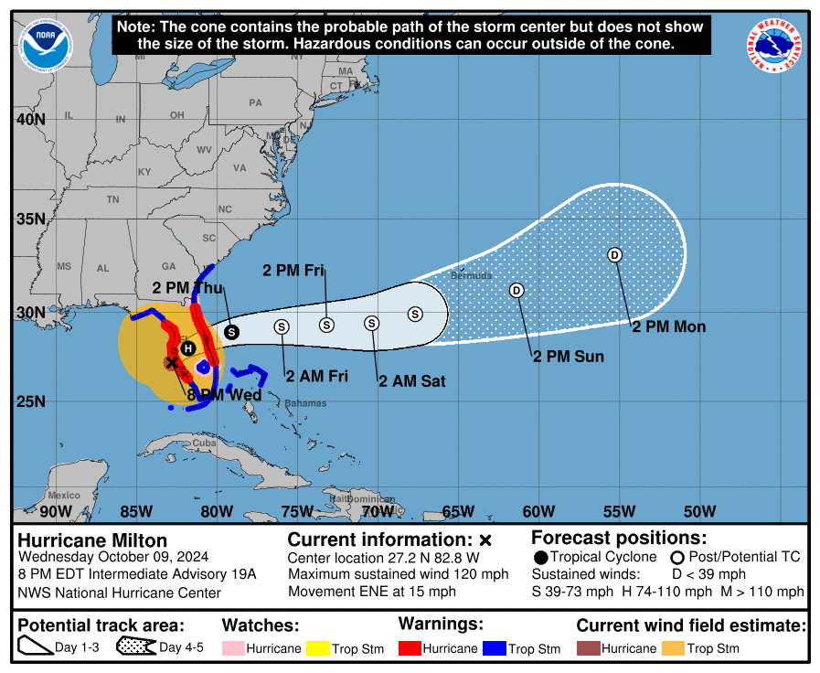
LOCATION…27.2N 82.8W
ABOUT 20 MI…30 KM WSW OF SARASOTA FLORIDA
ABOUT 130 MI…205 KM SW OF ORLANDO FLORIDA
MAXIMUM SUSTAINED WINDS…120 MPH…195 KM/H
PRESENT MOVEMENT…ENE OR 60 DEGREES AT 15 MPH…24 KM/H
MINIMUM CENTRAL PRESSURE…954 MB…28.17 INCHES
Milton is currently moving NE at 15 mph, with a pressure of 954 mb. Sustained winds were measured to be 120 mph. This is a very dangerous storm, and high wind gusts are being reported on the coast of Florida. Landfall will occur within the next two hours just south of the Tampa Bay area. This will be the worst of it. However, dangerous conditions will persist until Milton works its way into the Atlantic sometime tomorrow.
If you are in the Tampa Bay area, please continue to take shelter as the storm moves past. In the areas where the eye passes over, there will be a few minutes of silence. However, this will not be the end of it. Once the eye passes fully over, the other side of the eyewall will pass over and bring more dangerous winds. Listen to local officials and your local NWS office regarding when it is safe to stop sheltering.
We will continue to update as this hurricane makes landfall.
Category: ALL POSTS, Social Media, Tropical
About the Author (Author Profile)
Scott is a senior at Mississippi State University studying professional and broadcast meteorology.Subscribe
If you enjoyed this article, subscribe to receive more just like it.


