
4PM CDT Hurricane Milton Update: High Winds and Heavy Rainfall in Florida Ahead of Landfall
Hurricane Milton is currently a category 3 hurricane, with winds near 120 mph and a pressure of 948 mb. Although the system has recently been affected by high wind shear, it is still a very dangerous storm. Landfall is expected to occur overnight tonight near the Tampa Bay area.
Here are the latest stats from the NHC:
SUMMARY OF 500 PM EDT…2100 UTC…INFORMATION
———————————————-
LOCATION…26.9N 83.4W
ABOUT 60 MI…100 KM WSW OF SARASOTA FLORIDA
ABOUT 170 MI…275 KM SW OF ORLANDO FLORIDA
MAXIMUM SUSTAINED WINDS…120 MPH…195 KM/H
PRESENT MOVEMENT…NE OR 35 DEGREES AT 17 MPH…28 KM/H
MINIMUM CENTRAL PRESSURE…948 MB…28.00 INCHES
SUMMARY OF WATCHES AND WARNINGS IN EFFECT:
A Storm Surge Warning is in effect for…
* Florida west coast from Flamingo northward to Yankeetown,
including Charlotte Harbor and Tampa Bay
* Sebastian Inlet Florida to Altamaha Sound Georgia, including the
St. Johns River
A Hurricane Warning is in effect for…
* Florida west coast from Bonita Beach northward to Suwannee River,
including Tampa Bay
* Florida east coast from the St. Lucie/Martin County Line northward
to Ponte Vedra Beach
A Hurricane Watch is in effect for…
* Lake Okeechobee
* Florida east coast from the St. Lucie/Martin County Line to the
Palm Beach/Martin County Line
A Tropical Storm Warning is in effect for…
* Florida Keys, including Dry Tortugas and Florida Bay
* Lake Okeechobee
* Florida west coast from Flamingo to south of Bonita Beach
* Florida west coast from north of Suwanee River to Indian Pass
* Florida east coast south of the St. Lucie/Martin County Line to
Flamingo
* North of Ponte Vedra Beach Florida to Edisto Beach South Carolina
* Extreme northwestern Bahamas, including Grand Bahama Island, the
Abacos, and Bimini
Milton is currently moving towards the northeast at 17 mph. The expected landfall area remains as the Tampa Bay area, or just south of this area. It is important to remember that while the hurricane has shifted from a category 4 to category 3, it retains its status as a major hurricane and likely will continue this through landfall. We expect Milton to produce hurricane force winds as it traverses across Florida, as well.
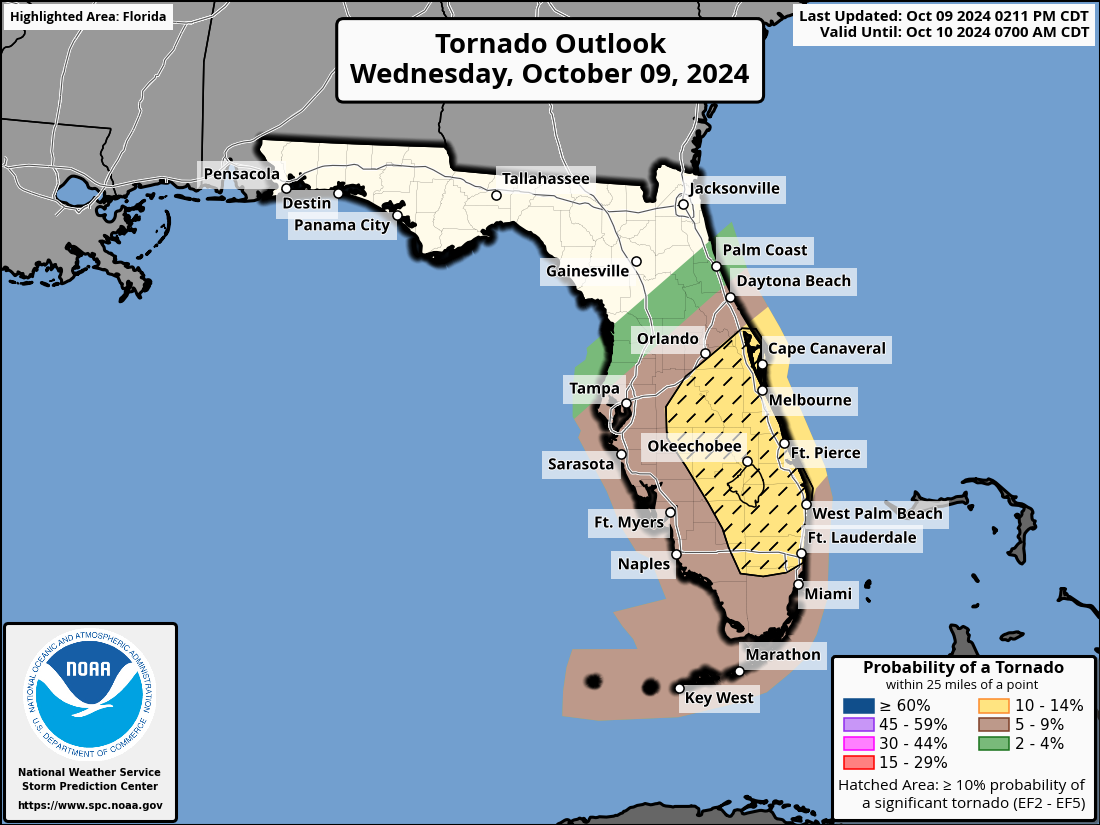
Right now, hurricane force winds extend 35 miles from the center of the storm, and tropical storm force winds extent 255 miles. Florida is already experience tropical storm force winds as the wind field is quite large. For residents in Central and Southern Florida, now is the time to stay sheltered and avoid leaving your safe spot. Tornado warnings have been issued in many parts of the Florida Peninsula today, and there is great potential for this trend to continue into tomorrow. Please have multiple ways to receive weather alerts.
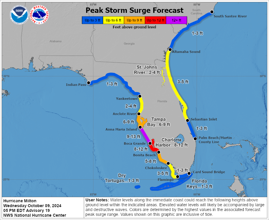
As far as impacts go, not a lot has changed. Forecasted surge amounts have decreased slightly, which is good news. However, any amount of surge is dangerous, and residents should be prepared for flooding to arise from hurricane-induced surge. Many areas could still see up to 13ft of surge, and this will be devastating to those areas. Here is a graphic outline forecasted surge amounts:
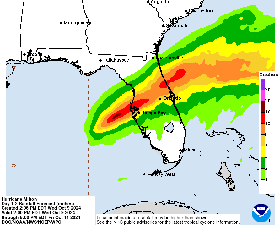
Rain will continue to fall throughout the day today and most of the day tomorrow in Central Florida. The outer bands of Milton have produced a lot of rainfall already, and this will continue until the storm moves off into the Atlantic. Here are forecasted rainfall amounts through Friday:
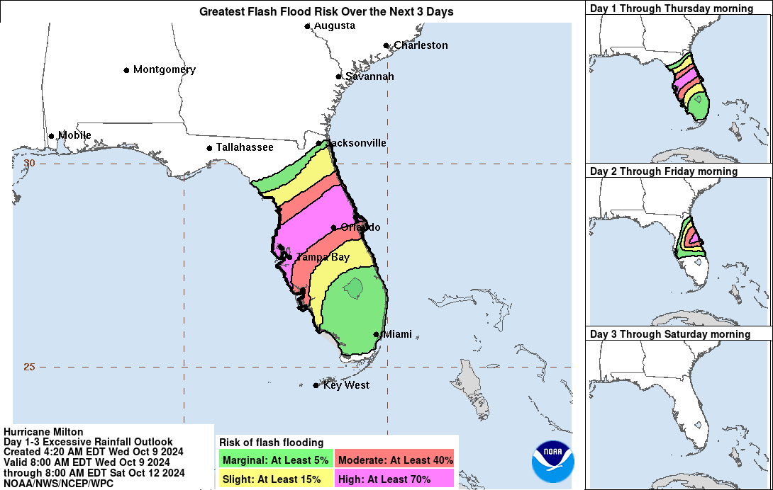
With this much rain, flash flooding across the state is a large concern. Central Florida, including Tampa Bay, Tampa, and Orlando, have the highest risk of flash flooding over the next couple of days. Here is a graphic outlining these risks:
The tornado threat for Florida continues today and overnight tonight. Here is a graphic showing the risk areas for tornadoes:
We will continue to update with each hourly update produced by the NHC. Stay tuned.
Category: ALL POSTS, Social Media, Tropical
About the Author (Author Profile)
Scott is a senior at Mississippi State University studying professional and broadcast meteorology.Subscribe
If you enjoyed this article, subscribe to receive more just like it.


