1PM CDT Hurricane Milton Update: Growing in Size; Tornadoes Reported in South Florida
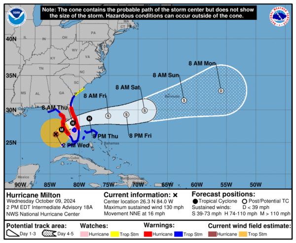
It’s a scary day for Florida. An angry Milton is racing towards the Florida Coast, and is only 150 miles SW of Tampa. Right now, sustained winds are 130 mph, and the pressure is at 944 mb.
Here are the latest stats from the NHC:
SUMMARY OF 200 PM EDT…1800 UTC…INFORMATION
———————————————-
LOCATION…26.3N 84.0W
ABOUT 130 MI…210 KM W OF FT. MYERS FLORIDA
ABOUT 150 MI…240 KM SW OF TAMPA FLORIDA
MAXIMUM SUSTAINED WINDS…130 MPH…215 KM/H
PRESENT MOVEMENT…NNE OR 30 DEGREES AT 16 MPH…26 KM/H
MINIMUM CENTRAL PRESSURE…944 MB…27.88 INCHES
SUMMARY OF WATCHES AND WARNINGS IN EFFECT:
A Storm Surge Warning is in effect for…
* Florida west coast from Flamingo northward to Yankeetown,
including Charlotte Harbor and Tampa Bay
* Sebastian Inlet Florida to Altamaha Sound Georgia, including the
St. Johns River
A Hurricane Warning is in effect for…
* Florida west coast from Bonita Beach northward to Suwannee River,
including Tampa Bay
* Florida east coast from the St. Lucie/Martin County Line northward
to Ponte Vedra Beach
A Hurricane Watch is in effect for…
* Dry Tortugas
* Lake Okeechobee
* Florida west coast from Chokoloskee to south of Bonita Beach
* Florida east coast north of Ponte Vedra Beach to the mouth of the
St. Marys River
* Florida east coast from the St. Lucie/Martin County Line to the
Palm Beach/Martin County Line
A Tropical Storm Warning is in effect for…
* Florida Keys, including Dry Tortugas and Florida Bay
* Lake Okeechobee
* Florida west coast from Flamingo to south of Bonita Beach
* Florida west coast from north of Suwanee River to Indian Pass
* Florida east coast south of the St. Lucie/Martin County Line to
Flamingo
* North of Ponte Vedra Beach Florida to the Savannah River
* Extreme northwestern Bahamas, including Grand Bahama Island, the
Abacos, and Bimini
A Tropical Storm Watch is in effect for…
* North of the Savannah River to South Santee River South
Carolina
We are expecting landfall to occur sometime early tomorrow morning, around 2-3AM CDT. Milton will remain at hurricane strength for the entire time is crosses over the Florida Peninsula. Tropical storm force winds are already being felt in parts of Florida, and there have been numerous reports of tornadoes in South Florida. The impacts of Milton will be felt by millions of people, and its story will be a haunting one.
The overall structure of Milton has began to look less impressive than previously, but the hurricane is still extremely strong. We are still expecting wind speeds to be major hurricane level force once the storm makes landfall near Tampa.
Dangerous levels of surge and rainfall will be associated with this storm. Flooding and flash flooding are large concerns for the next few days.
More updates to come. A full breakdown of the next NHC advisory will be posted later this afternoon.
Category: ALL POSTS, Social Media, Tropical


