Midday Nowcast: Feeling Like Fall in Alabama; Milton Heading Towards West Coast of Florida Tonight
OH SO NICE: It is finally feeling like fall with sunny days and fair cool nights the rest of this week. Highs will be in the upper 70s and low 80s, with lows in the 50s. Some of the colder pockets across North Alabama could reach the 40s early Friday morning. This is a very dry air mass, meaning no humidity, and no rain as a long dry spell settles into Alabama.
BIRMINGHAM ALMANAC: For October 9th, the average high for Birmingham is 79° and the average low is 57°. The record high is 91° set in 1941, while the record low is 34° set in 2000. We average 0.10” of precipitation on this date, and the record value is 3.92” set in 1934.
FOOTBALL TONIGHT: Jacksonville State hosts New Mexico State (6:30p CT kickoff)… the sky will be clear with temperatures falling through the 70s.
WEEKEND AND BEYOND: The pattern doesn’t change as we roll into the weekend and next week. It is a dry forecast for the Deep South with sunny pleasant days and clear cool nights. Highs will be mostly in the upper 70s and low 80s, with lows in the 50s over the northern and central counties. Even cooler air arrives next week; highs drop into the 60s with lows in the 40s over the northern 2/3 of the state by Tuesday and Wednesday. And, still no sign of any meaningful rain for Alabama for at least the next 7-10 days.
FOOTBALL WEATHER: Expect a clear sky for the high school games across Alabama Friday night with temperatures falling from the low 70s at kickoff, into the 60s during the second half.
Saturday, Alabama hosts South Carolina (11:00a CT kickoff) at Bryant-Denny Stadium… the sky will be sunny with temperatures rising from near 77 at kickoff, into the low 80s by the final whistle.
UAB is on the road; they play Army in West Point NY (11:00a CT kickoff)… the weather will be dry. With a sunny sky, temperatures rise from 68 degrees at kickoff into the low 70s by the fourth quarter.
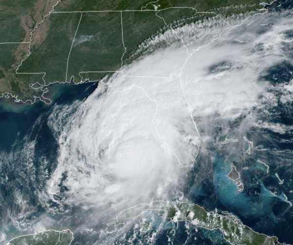
HURRICANE MILTON: Milton is a very dangerous storm which will bring significant impacts to Florida from a devastating storm surge, to winds over 100 mph as it crosses the state, to extreme flash flooding, and tornadoes.

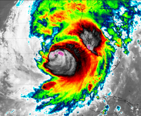
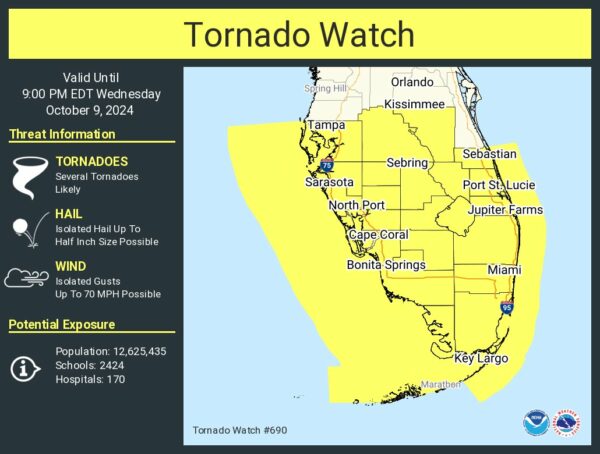
Tornadic supercells from Milton are beginning to sweep across the southern Florida peninsula and a tornado watch is in effect.
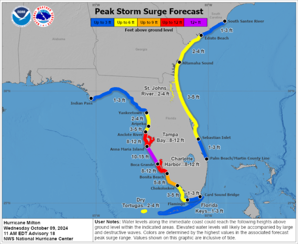
Record storm surges are expected along the west coast of Florida.
Latest update from the National Hurricane Center had the center of Hurricane Milton was located near latitude 25.8 North, longitude 84.3 West. Milton is moving toward the northeast near 17 mph. A northeastward motion with some decrease in forward speed is expected through this evening. A turn toward the east-northeast and east is expected on Thursday and Friday. On the forecast track, the center of Milton will move across the eastern Gulf of Mexico today, make landfall along the west-central coast of Florida tonight, and move off the east coast of Florida over the western Atlantic Ocean on Thursday.
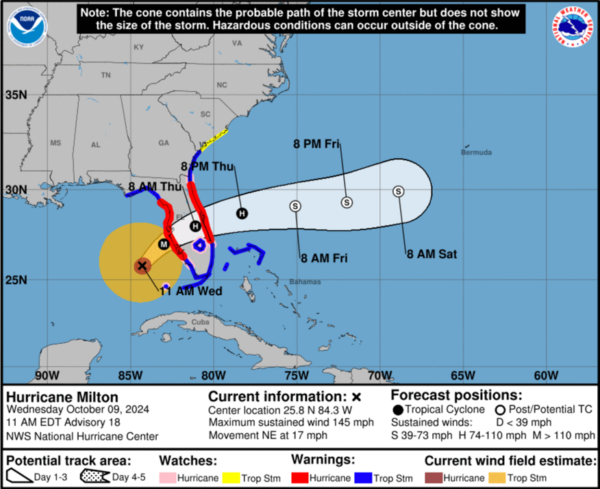
Maximum sustained winds are near 145 mph with higher gusts. Milton is a category 4 hurricane on the Saffir-Simpson Hurricane Wind Scale. Milton is expected to remain an extremely dangerous major hurricane when it reaches the west-central coast of Florida tonight, and remain at hurricane strength while it moves across the Florida peninsula through Thursday. Gradual weakening is forecast while Milton moves eastward over the western Atlantic, and it is likely to become an extratropical storm by early Friday.
Hurricane-force winds extend outward up to 35 miles from the center and tropical-storm-force winds extend outward up to 175 miles. A NOAA saildrone (SD-1083) located approximately 80 miles northeast of the center recently reported a sustained wind of 44 mph with a gust of 57 mph. The minimum central pressure based on Air Force Reserve Hurricane Hunter data is 931 mb (27.50 inches).
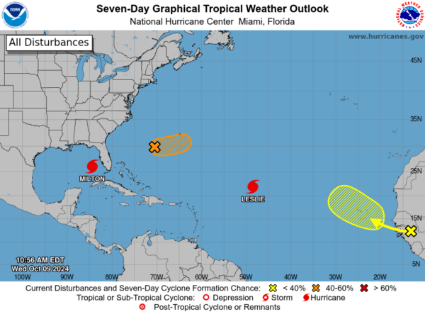
REST OF THE TROPICS: Leslie is back up to a hurricane with winds of 85 mph, but will remain a fish storm. The other areas the NHC is monitoring, one has a medium chance while the other has a low chance of development the next seven days.
WORLD TEMPERATURE EXTREMES: Over the last 24 hours, the highest observation outside the U.S. was 113.4F at Ratlam, India. The lowest observation was -84.3F at Amundsen-Scott South Pole Station, Antarctica.
CONTIGUOUS TEMPERATURE EXTREMES: Over the last 24 hours, the highest observation was 113F at Tecopa, CA. The lowest observation was 15F at Isabella, MN.
Category: Alabama's Weather, ALL POSTS, Social Media
About the Author (Author Profile)
Macon, Georgia Television Chief Meteorologist, Birmingham native, and long time Contributor on AlabamaWX. Stormchaser. I did not choose Weather, it chose Me. College Football Fanatic. @Ryan_StinnetSubscribe
If you enjoyed this article, subscribe to receive more just like it.


