7am CDT Update: Dangerous Major Hurricane Milton Moving a Bit Quicker, Preparations Should Be Rushed to Completion
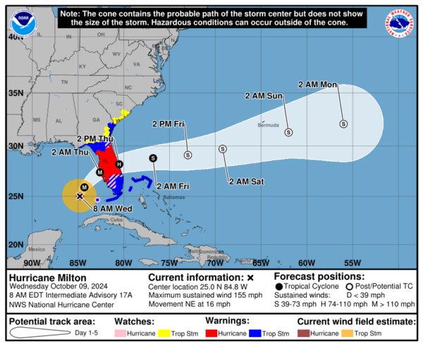
Here is the latest update from the NHC and a quick look at radar too.
Stats:
LOCATION…25.0N 84.8W
ABOUT 120 MI…195 KM W OF THE DRY TORTUGAS
ABOUT 250 MI…405 KM SW OF TAMPA FLORIDA
MAXIMUM SUSTAINED WINDS…155 MPH…250 KM/H
PRESENT MOVEMENT…NE OR 40 DEGREES AT 16 MPH…26 KM/H
MINIMUM CENTRAL PRESSURE…915 MB…27.02 INCHES
No changes to current watches and warnings in this advisory
Hurricane-force winds extend outward up to 30 miles (45 km) from the center and tropical-storm-force winds extend outward up to 125 miles (205 km).
Milton is starting to encounter some of that projected shear and there has been a slight decrease in the max winds at the center. Folks, it doesn’t really matter at this point. We have a dangerous Category 4 hurricane heading to the west-central coast of Florida with catastrophic impacts expected. Life-threatening storm surge, inland and coastal flooding, destructive winds and tornadoes all expected.
There is starting to become an alignment with the dynamical and global models of a landfall just south of Tampa Bay possibly near the Sarasota area. This will be fine-tuned and monitored through the day.
Tropical systems are not just a point though and we can’t reiterate enough how widespread the impacts will be.
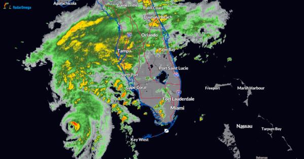
Here is a snapshot of the current MRMS radar showing the Florida peninsula. Rain shield increase over the Tampa and Sarasota areas. Strong to severe storms with the capability of producing fast-moving tornadoes off shore and over south Florida. The tornado threat will increase as the day goes on.
More to come as the day goes on and through the night as we follow the progress of Milton.
Category: ALL POSTS, Social Media, Tropical


