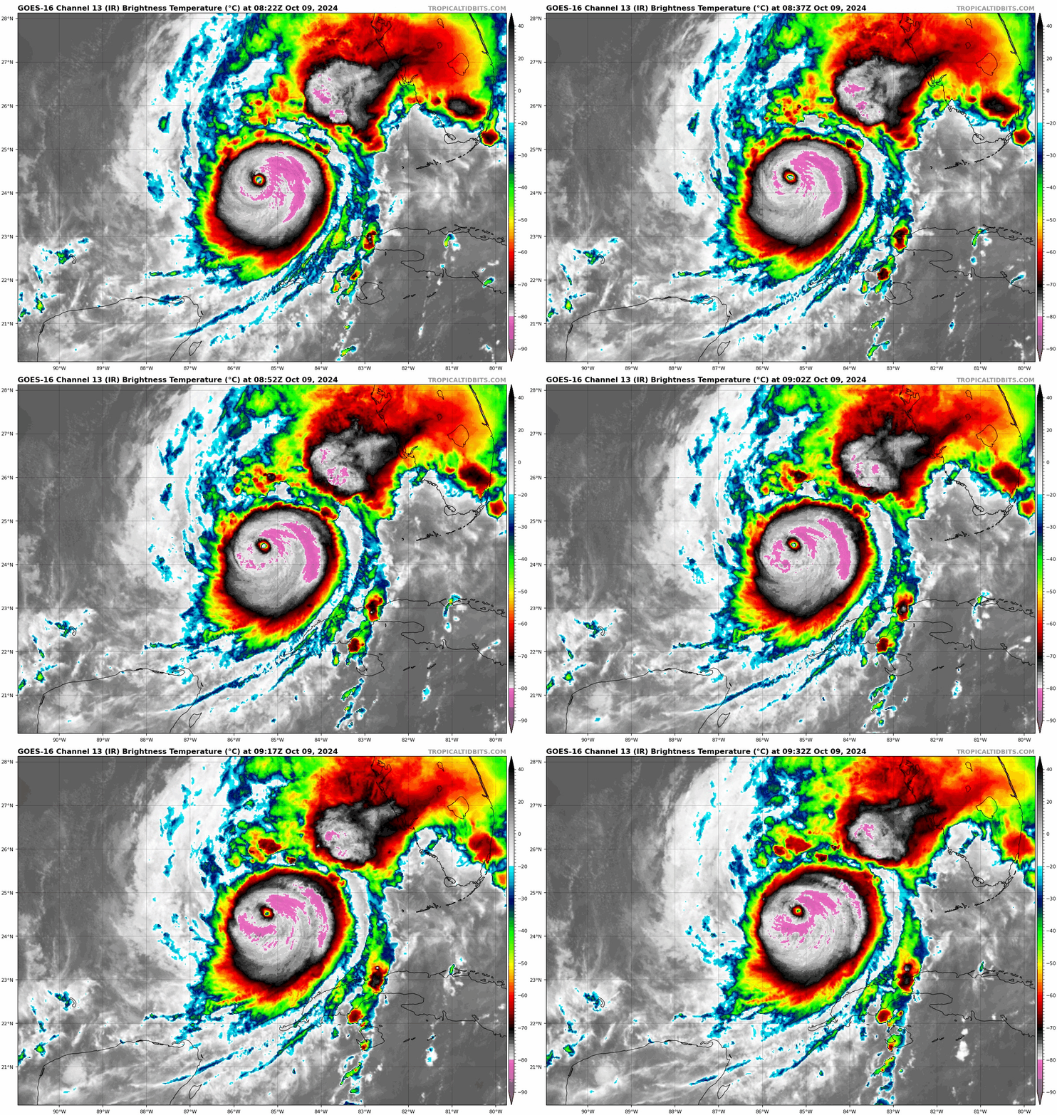
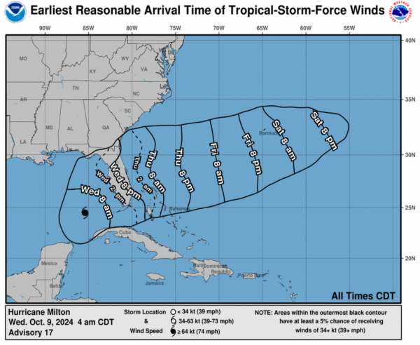
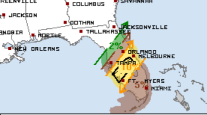
4am CDT Update: Milton Has Maintained Strength; Landfall Expected Late Tonight
Good morning everyone. A lot to process with the latest on Milton and I will lay it all out in this post. Florida needs to be ready for this devastating storm. A rush to protect life and property needs to happen today. Let’s start with the latest stats:
STATS:
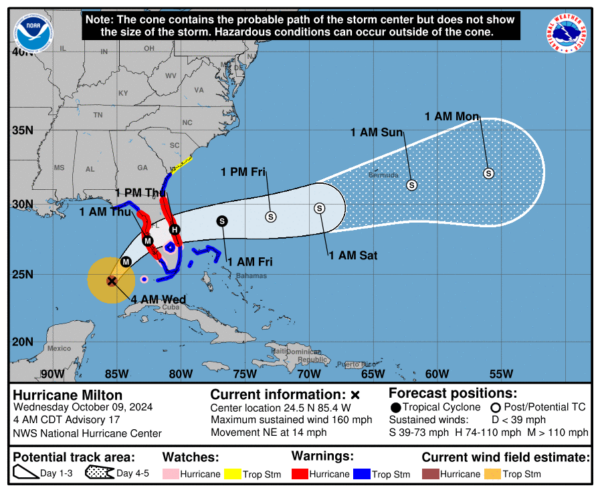
LOCATION…24.5N 85.4W
ABOUT 160 MI…255 KM W OF THE DRY TORTUGAS
ABOUT 300 MI…485 KM SW OF TAMPA FLORIDA
MAXIMUM SUSTAINED WINDS…160 MPH…260 KM/H
PRESENT MOVEMENT…NE OR 45 DEGREES AT 14 MPH…22 KM/H
MINIMUM CENTRAL PRESSURE…907 MB…26.78 INCHES
SUMMARY OF WATCHES AND WARNINGS IN EFFECT:
A Storm Surge Warning is in effect for…
* Florida west coast from Flamingo northward to Yankeetown,
including Charlotte Harbor and Tampa Bay
* Sebastian Inlet Florida to Altamaha Sound Georgia, including the
St. Johns River
A Hurricane Warning is in effect for…
* Florida west coast from Bonita Beach northward to Suwannee River,
including Tampa Bay
* Florida east coast from the St. Lucie/Martin County Line northward
to Ponte Vedra Beach
A Storm Surge Watch is in effect for…
* North of Altamaha Sound Georgia to Edisto Beach South Carolina
A Hurricane Watch is in effect for…
* Dry Tortugas
* Lake Okeechobee
* Florida west coast from Chokoloskee to south of Bonita Beach
* Florida east coast north of Ponte Vedra Beach to the mouth of the
St. Marys River
* Florida east coast from the St. Lucie/Martin County Line to the
Palm Beach/Martin County Line
A Tropical Storm Warning is in effect for…
* Florida Keys, including Dry Tortugas and Florida Bay
* Lake Okeechobee
* Florida west coast from Flamingo to south of Bonita Beach
* Florida west coast from north of Suwanee River to Indian Pass
* Florida east coast south of the St. Lucie/Martin County Line to
Flamingo
* North of Ponte Vedra Beach Florida to the Savannah River
* Extreme northwestern Bahamas, including Grand Bahama Island, the
Abacos, and Bimini
A Tropical Storm Watch is in effect for…
* North of the Savannah River to South Santee River South
Carolina
Keys Points from the NHC Discussion:
- Milton is still a Category 5 storm, 300 miles SW of Tampa.
- The storm is moving to the northeast at 14 mph. It has picked up the pace through the night. This motion is expected to continue as Milton moves between a mid/upper level trough over the northern Gulf and a ridge over the Greater Antilles. A landfall along the west-central Florida coast expected late tonight. After landfall, it will get pulled east-northeast, race across the state and head out into the Atlantic.
- Still looking at a landfall somewhere from Tampa Bay/Sarasota area. The impacts are going to be so far-reaching and it is going to be devastating for a large part of the state. I will highlight those impacts below.
- The models still indicated a high amount of shear will disrupt the storm SOME but not enough not to have major hurricane approaching the coast. The official forecast has winds at 130 mph at the center around landfall time. This could be higher if the shear does not cut down on the intensity.
- The NHC has had this statement in the last several discussions, including this one. And it really brings home what we are looking at here: “Milton has the potential to be one of the most destructive hurricanes on record for west-central Florida.”
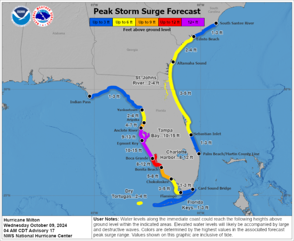
Storm Surge:
This is going to be catastrophic for a large area of the coast. Noone should be along the coast and try to ride this out. You can’t.
Egmont Key, FL to Boca Grande, FL…10-15 ft
Tampa Bay…10-15 ft
Anclote River, FL to Egmont Key, FL…9-13 ft
Boca Grande, FL to Bonita Beach, FL…8-12 ft
Charlotte Harbor…8-12 ft
Bonita Beach, FL to Chokoloskee, FL…5-8 ft
Aripeka, FL to Anclote River, FL…4-7 ft
Chokoloskee, FL to Flamingo, FL…3-5 ft
Sebastian Inlet, FL to Altamaha Sound, GA…3-5 ft
Altamaha Sound, GA to Edisto Beach, SC…2-4 ft
Yankeetown, FL to Aripeka, FL…2-4 ft
Dry Tortugas…2-4 ft
St. Johns River…2-4 ft
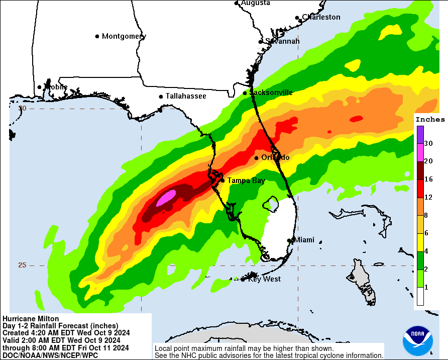
Flooding:
This is a huge concern starting through the day today straight through tomorrow. Moisture is already being pulled into Florida so bands of heavy rain will start up today. The potential is there for someone to walk away with 12-18 inches of rain.
Wind:
Hurricane conditions could begin in the hurricane warning areas as early as this evening with tropical storm conditions arriving around midday.
Tornadoes:
This is a big concern. In fact, we have already had a tornado warning this morning for Miami-Dade County. The SPC has enhanced their wording on the tornado risk and mentions a strong tornado or two could occur during the mid to late afternoon, when instability and shear will be locally maximized. This is one of the higher tropical tornado risks I have seen in awhile.
Final Thoughts: Folks, we can’t reiterate enough that if you have friends and family in the path of this hurricane, they need to heed the advice of the local officials. Noone should be along the coast especially in the hurricane warning. And this is on both sides of the Florida coast. There will be major surge on the east coast of Florida as well as Milton exits the state. There will be some surge in the Big Bend area. For those who are inland, preparations must be rushed to completion. Impacts from Milton will increase through the day, peak tonight and Thursday and then by Friday, Milton will be long gone and we have to come back and see what damage has been done and I am afraid the damage will be catastrophic for some.
Be there for one another. Help each other. Serve one another. We will all get through this together and we will do our part here at Alabama WX to pass information your way. Thank you for reading.
Category: ALL POSTS, Social Media, Tropical

